
| Date | 10/15/2011 |
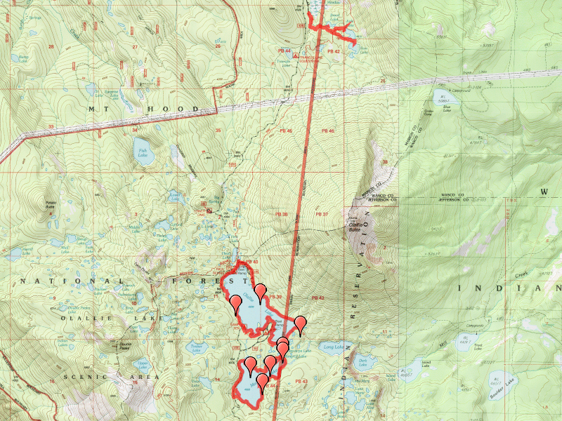
| Location / Trail | Russ Lake Trail, Olallie, Mon-Olallie and Monon Lake trails - 716, 729, 731, 732 |
| Weather | Overcast and foggy most of the day |
| Hiking Buddies | Bodie (my dog) |
| Start / End | 10:00 AM – 3:00 PM |
| Distance / Elev | 9.5 miles |
What I thought was going to be a great day weather wise turned out to be rather foggy and overcast. It wasn’t too hot and wasn’t too cool, probably in the low 60’s I’d guess. Not a bad day to do hikes out in the open.
These trails are all very flat, probably no more than 75 feet elevation gain/loss, so the hikes went pretty quickly. Started the hikes doing the short Russ Lake trail, and took the side trip to Jude lake. Interesting area with some nice campsites. Both lakes are on tribal land.
Next, moved to the Olallie area and did the 3 trails around and between Olallie and Monon lake(s). It was interesting to see the burned areas, although it did quite a bit of damage to the forest. Seeing the non-burned areas, I would have loved to have seen the area before the fires. The area is starting to recover, but it is going to take quite some time.
The south side of Olallie and the east side of Monon lake really took the brunt of the fire damage. Once you get to the southern part of Monon lake, you get out of the fire damaged area and into the woods again. You cross over several sections of marshy area where there have been raised sections of trail built. Walking around Monon lake is very nice. The trail doesn’t go completely around the lake since the road (4220 road) follows the western part of the lake – you walk up the road to the “start” of the trail just south of where 4220 meets the lake. We continued around monon, coming back into the burn zone and then back up the Mon-Olallie lake trail to Olallie. Continued around Olallie lake clockwise. Got to the spot where the trail stops (where it hits 4220) and hiked back up the road a ways. Stopped for bit to pick huckleberries along the way. It looks like portions of the trail continue along the lake shore (it was flagged in places), but the trail doesn’t really continue all the way around. Ended up walking back up the road to where we started (at the junction to the resort which had been blocked by boulders for the winter). Walked back up past the resort to pick more huckleberries and then came home.
I was a little disappointed that the weather didn’t burn off, but it was still a good day in the woods and I’m glad I got a chance to see this area in more detail. I would really like to explore the southern part of Monon lake some more some day.