
| Date | 1/14/2012 |
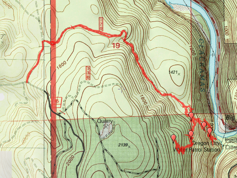
| Location / Trail | The old "Gipper" Trail - from the Clackamas River up to an old camp site |
| Weather | Overcast with rain late in the day |
| Hiking Buddies | Don, Kirk and Murphy (the dog) |
| Start / End | 8:15 AM – 2:00 PM |
| Distance / Elev | 7 miles |
Since there was supposed to be a “snow event” that day, we decided to get an early start on things, hoping to beat the weather that was supposed to come in. On the way to the road (our starting point), we got a little bit of rain, but that was it. Almost the rest of the day, we didn’t have any rain to speak of, and the underbrush was dry.
We started off down a road that led through to a BLM land, a clearcut and then to USFS land, passing an old research area that was fenced off – except for the corner where the gate used to be…..You could walk in the research area if you wanted to. Not sure what they were researching, but it looked rather messy and overgrown. We continued down the old road to the end, and then went cross country through a grove of alders – this was an old clearcut that didn’t appear to have been replanted – the alders seemed to be natural volunteers. Once through the alder grove, we worked our way south to an old 4 way junction of trails. Although the trails were readily apparent, you could still see the sign on the trees. The sign was in excellent condition, considering how old it must have been. Don was leading, and knew the trail down to the river, but we found a side trail that we think eventually led up to the old camp. We followed this trail as far as we could, locating quite a bit of REALLY good tread, with only a few rough spots. We followed it up to another old clearcut, where you could still see the tread, but it was VERY overgrown – we decided to stop locating trail at that point – but, we located probably 6 or 7 tenths of a mile of the old trail. Very Cool!
After finding all that tread, we headed back the way we came, back to the old junction. We then took the trail down to the river – most of this trail is in pretty good shape. There are a few rough spots going down the hill, but, surprisingly enough, going back up was almost easier than coming down! We made our way down to the junction with the pipeline trail and had lunch. We then proceeded back uphill, doing some trail maintenance along the way. I ended up breaking the jaw on my compact loppers, so we didn’t get quite a much done as I would have liked, but we still did a fair amount. Lopping off branches, clearing the trail, kicking off rocks and cutting some of the smaller branches – we left the trail in better shape than we found it.
After the 4 way junction, we took a slightly different way back – we walked along the boundary line – the boundary between BLM and FS land. Many of the trees were marked (some with an X chopped into them, some with a plate). We found the section corner marker in the ground! It was interesting to find all this old history.
The hike back to the truck was mostly uneventful, however we were racing to get back before the big rain/snow event hit. When we got to the clearcut, it was starting to rain, and it got heavier, although most of the time we were in the trees. It started raining pretty heavily just before we got to the vehicles, and shortly after we started driving out, we got rain, snow, sleet all mixed together. We timed the hike pretty well! A stop at Fearless Brewing in Estacada for a Strong Scotch Ale and some fries made a great end to a great day.