
| Date | 1/1/2013 |
| Location / Trail | Abandoned Broughton Log Flume Exploration |
| Weather | Overcast and rather cold |
| Hiking Buddies | Kirk |
| Start / End | 11:00 AM – 2:30 PM |
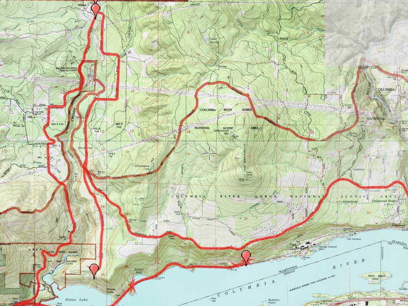
| Distance / Elev | 2 miles (more driving than hiking - the map is mostly showing the route we took driving the area) |
One of the interesting things I found was the “alarm” system that the flume had. It had wires on the downhill side of the flume (from the Chenoweth road crossing down to the Hood mill) and if one of those wires were cut, the flume would automatically shut down and divert all its water to Drano lake. There was concern that if there were a leak on the side of the hill, it could cause rocks or trees to come tumbling down the hill onto the trains and cars below. The alarm system and bypass mechanism was near the Chenoweth road crossing.
OK, enough of the facts and figures of the flume itself. On to the description of the trip. We started out early on New Years Day – it was cold and the roads were icy in spots. No matter, it was a good day to go exploring – a great way to start a new year. We got to Hood River and made the trip over the toll bridge (it was $1 each way). We stopped in the small town of Bingen to look at a steel portion of the flume that used to go over a roadway. It had some history of the flume and some photos that were interesting to see. After this stop, we were ready to go looking for what was left of the flume. We headed west on Highway 14 until just before tunnel 5 (I think that is the right tunnel-maybe it was tunnel 6). Anyway, there was a nice place to pull off the road. We headed back up the road a bit to get around the cliff. Then we headed up. In less than 100 feet up, we found remnants of the flume. There was LOTS of poison oak all over the place, but since it was cold, and the plants were all in hibernation for the winter, I think we were OK. It was interesting to walk down the flume line and see how far it has degraded in a short time.

There was also a section that was in reasonably good shape:

We also saw the wires for the alarm system:

After poking about those pieces for a while and enjoying the view of the river, we headed back down and continued west on highway 14 until we got to Draino Lake. WOW, was the wind howling there! And it was COLD! We stopped just long enough to look at the plaque they had at the boat ramp and then continued west to Cook-Undewood road, and then headed north towards Willard (where the upper mill was). We passed through “Mill A”, a small mill town, and after taking a left fork on Willard Road, eventually got to the small town of Willard (population 46 according to the town sign). In Willard, we saw the long metal flume that went across Cook-Underwood road:

As you can see, there was a fair amount of snow on the ground. I was surprised, since we were only at about 1200′ of elevation. Near this piece of flume, we also saw a family of deer resting in the front yard of one of the houses:

Driving a little further up the road, we found one of the best preserved pieces- this piece didn’t actually carry any cants, it was the “feeder” flume from the dam on the Little White Salmon river to the mill in Willard where it picked up the cants:

From there, we saw where the flume crossed the Little White Salmon River:

We kept driving down Willard Road (it kind of makes a U Turn) looking for more remains of flume. The flume was supposed to parallel the road, but we could see no evidence of it. We then proceeded to what I found to be the most interesting part of the trip. We went down Chenoweth road, almost to the end. At this point, the flume went under the road – there was quite a bit of flume left in this area. Seeing no “No Trespassing” signs, we went and explored the pieces of old Flume. On one side of the road was pieces of flume, some elevated as much as 8 feet or so. Some pieces were pretty much ruined, but some were in relatively good shape. On the other side of the road was the interesting piece. This was the place where the “alarm” worked. There was a small building next to a trap door. When the alarm was triggered, the motor in the building opened the trap door and all the water ended up going down to Drano Lake rather than continuing down the flume.


There was some old “decking” which looked like it could have been used for a variety of things (removing jammed up logs if the alarms triggers, sending replacement lumber down the line for flume repairs, etc). As we got back to the car, there was a nice gentlemen on a tractor who informed us that we were now on a nature preserve. We told him we were interested in looking at the remains of the flume and he told us stories of what it was like and how the “alarm” worked. It was great to hear stories from someone who had actually seen it work. Apparently after it use was discontinued in 1986, many (most?) sections of it were sold off – reclaimed. About the only sections that were not were sections that were either in inaccessible areas, or those on private property. The area where the nature preserve is located is private property and the owners had opted to keep the flume in place. Thank goodness for that! It is too important of a historical treasure to leave to rot! Even better, they are discussing preserving a section of the flume permanently so that people can see what it looked like.
After talking with the nice gentleman (I never got his name, just that he was the caretaker of the preserve), we headed out, and back down to Bingen and then back home. While we didn’t do a lot of actual hiking, it was a great day out exploring this bit of NW history.