
| Date | 4/20/2013 |
| Location / Trail | Upper Falls- South Fork Clackamas River - Old Memaloose Trail |
| Weather | Mostly overcast - a little misty but with some sun breaks |
| Hiking Buddies | Kirk |
| Start / End | 9:15 AM – 6:00 PM |
| Distance / Elev | 7.9 miles |
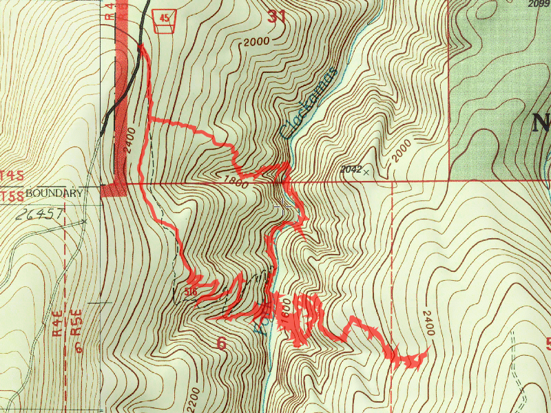
Description of Hike:
Kirk and I decided to explore the abandoned trail on the east side of the South Fork yesterday We made our first stop at the Upper South Fork Falls, heading downhill through one of the old forest service “vertical thinning cuts”. It was a rather difficult descent, but not too bad until you got right close to the river, where it got very steep. Fortunately, we figured out how to get down to the river without incident:

Here is panorama photo of the waterfall amphitheater:

This is a really cool waterfall – a very unique amphitheater with three separate water “falls” – two from the river (it splits into two streams at the top), and one on the side from a creek. The water was running so fierce today it was really roaring and churning as it hit the pool at the bottom.
After enjoying the waterfall(s) for a while, we scouted our route out of the amphitheater. Rather than bushwhack 800′ back up to the trail and then go back down the Hillockburn to the river, we opted to bushwhack upstream. I think that was a good choice, as it was only a little over a quarter of a mile to bushwhack. Although it wasn’t easy, I think it was easier than going back up the hill. Once we got to the campsite at the bottom of the Hillockburn trail, we stopped for a break and had lunch. After lunch (where we saw a few sun breaks), we looked for a log to cross the river on. We had been informed that there was a good log to cross near the campsite. A little bit downstream from the campsite, there was a good candidate. Crossing the log was relatively uneventful, and from there we bushwhacked back to where the trail crossed the river to find the old tread (what is left of it). The lower part of this trail is not very well defined – between marshy areas and lots of blowdown, you have to pay close attention. We kept looking for cut logs – that is how we followed this lower section of trail. We did not see any blazes down lower and ended up losing the trail not too far from the start. We wandered around looking for bench, but didn’t find any (we had wandered too far south), but we did find some interesting side hill meadows:

There was some sort of waterfall on the creek down below, but we didn’t feel comfortable going down to look – the walls were close to vertical as you got farther downhill, so this is the best shot I could get of it:

Above that little creek was this massive cliff face, which was very interesting:


After heading uphill looking for tread (and feeling like a goat since it was so steep) we decided to head farther north to see if we could find more trail. We ended up stumbling back across the trail! From this point, the trail was actually really easy to follow for the most part, with blazed and well defined tread.

The occasional blowdown mess made for tough going, but once you were past the blowdown, the trail was easy to follow. We followed it for a while, until it got to a point with a LOT of blowdown that was really big. Just up the hill from this, it almost looked like a thinning area where there was even more blowdown and made the trail very difficult to follow. The good news is that someone has been in there and it is reasonably well flagged. I added a few more flags to help navigate through some of these areas. After navigating through one final area of blowdown, and having the trail become rather faint (and also getting pretty tired), we decided to turn around. We ended up going up to within about 1/4 mile of an old road (at least it shows on the map). This was our turnaround spot:

On the way back down, I took a few more photos than on the way up. Here are remnants of an old footbridge:

Here are some of the MANY BIG trees (I think they are larger on this side of the canyon):

Some of the easier to follow trail through smaller trees:

We successfully followed the trail back downhill, recognizing where we lost it (we missed a switchback), and made it safely back across the South Fork River (I think this picture was taken while I was crossing the log over the river):

Once across we did our final bushwhack back to the campsite and trail, and then headed back uphill to the car. I have to tell you, that hike back uphill seemed a lot longer than I remember it! I’m sure it was because I was so tired. This was more bushwhacking than I’ve done in quite some time, and all of it was rather difficult. Very brushy, lots of trees to crawl over or under. It was good to get back to the car and rest my weary legs. I slept very well that night.
Here is panorama photo of the waterfall amphitheater:
This is a really cool waterfall – a very unique amphitheater with three separate water “falls” – two from the river (it splits into two streams at the top), and one on the side from a creek. The water was running so fierce today it was really roaring and churning as it hit the pool at the bottom.
After enjoying the waterfall(s) for a while, we scouted our route out of the amphitheater. Rather than bushwhack 800′ back up to the trail and then go back down the Hillockburn to the river, we opted to bushwhack upstream. I think that was a good choice, as it was only a little over a quarter of a mile to bushwhack. Although it wasn’t easy, I think it was easier than going back up the hill. Once we got to the campsite at the bottom of the Hillockburn trail, we stopped for a break and had lunch. After lunch (where we saw a few sun breaks), we looked for a log to cross the river on. We had been informed that there was a good log to cross near the campsite. A little bit downstream from the campsite, there was a good candidate. Crossing the log was relatively uneventful, and from there we bushwhacked back to where the trail crossed the river to find the old tread (what is left of it). The lower part of this trail is not very well defined – between marshy areas and lots of blowdown, you have to pay close attention. We kept looking for cut logs – that is how we followed this lower section of trail. We did not see any blazes down lower and ended up losing the trail not too far from the start. We wandered around looking for bench, but didn’t find any (we had wandered too far south), but we did find some interesting side hill meadows:
There was some sort of waterfall on the creek down below, but we didn’t feel comfortable going down to look – the walls were close to vertical as you got farther downhill, so this is the best shot I could get of it:
Above that little creek was this massive cliff face, which was very interesting:
After heading uphill looking for tread (and feeling like a goat since it was so steep) we decided to head farther north to see if we could find more trail. We ended up stumbling back across the trail! From this point, the trail was actually really easy to follow for the most part, with blazed and well defined tread.
The occasional blowdown mess made for tough going, but once you were past the blowdown, the trail was easy to follow. We followed it for a while, until it got to a point with a LOT of blowdown that was really big. Just up the hill from this, it almost looked like a thinning area where there was even more blowdown and made the trail very difficult to follow. The good news is that someone has been in there and it is reasonably well flagged. I added a few more flags to help navigate through some of these areas. After navigating through one final area of blowdown, and having the trail become rather faint (and also getting pretty tired), we decided to turn around. We ended up going up to within about 1/4 mile of an old road (at least it shows on the map). This was our turnaround spot:
On the way back down, I took a few more photos than on the way up. Here are remnants of an old footbridge:
Here are some of the MANY BIG trees (I think they are larger on this side of the canyon):
Some of the easier to follow trail through smaller trees:
We successfully followed the trail back downhill, recognizing where we lost it (we missed a switchback), and made it safely back across the South Fork River (I think this picture was taken while I was crossing the log over the river):
Once across we did our final bushwhack back to the campsite and trail, and then headed back uphill to the car. I have to tell you, that hike back uphill seemed a lot longer than I remember it! I’m sure it was because I was so tired. This was more bushwhacking than I’ve done in quite some time, and all of it was rather difficult. Very brushy, lots of trees to crawl over or under. It was good to get back to the car and rest my weary legs. I slept very well that night.
The abandoned trail on the east side of the South Fork Clackamas River deserves some attention. It is in really good shape other than the blowdown areas and goes through some absolutely beautiful forest. That will have to wait for another day, however.
A couple of videos of the waterfall: