
| Date | 2/16/2015 |
| Location / Trail | Grouse Point and Serene Lake Trails - 517 and 512 |
| Weather | Sunny and Breezy |
| Hiking Buddies | Bodie (my dog) |
| Start / End | 10:40 AM – 2:30 PM |
| Distance / Elev | 8.1 miles |
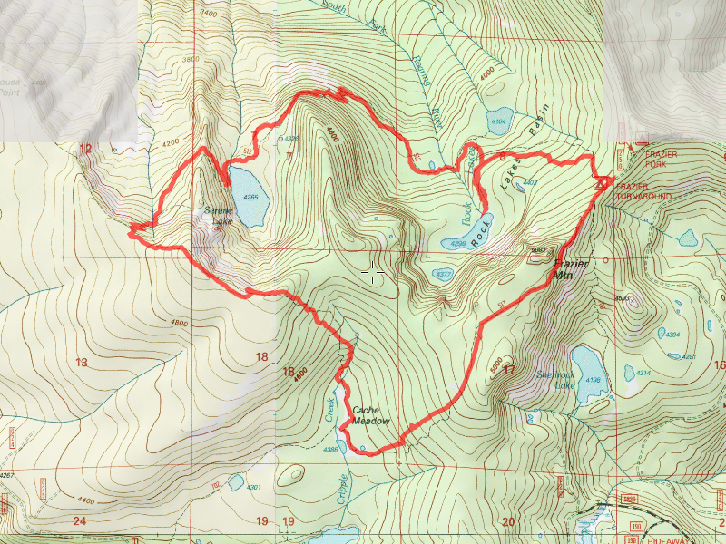
This hike was a President’s day outing. I had the day off (one of the perks working for a bank), so I decided to take advantage of the lack of snow this year. I thought I could make it up to Frazier turnaround to do a loop – Grouse Point to Serene Lake and then back. I wasn’t exactly sure what to expect, although since it was windy, I did pack the chainsaw in case some trees came down while I was hiking. Didn’t want to get the truck stuck behind a downed tree!
Anyway, the trip up to Frazier turnaround was uneventful until I got onto that horrible spur road. 4.4 miles of rutted, rocky, pothole pocked road. The first couple of miles were pretty typical, with almost no snow on them. Once the road takes a turn and gets a southern exposure, there started to be some snow on the road. I was a little leery of continuing, but thought I would try. The snow drifts were so compacted, and frozen, I basically just drove right over them, only sinking an inch or two. I continued down the road, and the only sketchy part was the long, narrow section on the big slide – but it wasn’t too bad with the truck. I got past that and the snow disappeared again. A little farther up the road, it was good I brought the chainsaw – there was a few small trees across the road which I cut with the saw. I made it to the turnaround in pretty good time, and this is what I saw when I got there:

A HUGE tree had come down and blocked the “turnaround” part of the road. I was to learn later that this tree actually was right next to the trail – it came down and now is hanging over the trail (although it is easy to walk under). It was a bit breezy at the turnaround, and a bit chilly, so I decided to head out quickly (to get my blood pumping and warm up). Getting over that big tree was a challenge for Bodie, but he finally figured it out. We headed up Grouse Point (an old road that has been converted to a trail), and shortly came to a big rockslide, which had VERY little snow:

Looking the other direction on that rockslide was our first incredible view of the day – looking down the Shellrock Creek drainage:

We continued down the road/trail, through a few small spots of snow, heading down thru the forest until we got to a partially frozen Cache Meadow:

After looking around the meadow a bit, we headed back uphill along the Grouse Point Trail. Shortly, we came to the helispot overlook above Serene Lake with its pitiful lack of snow on the ground at almost 5000′:

And I can’t do this trail without showing the wonderful view of Serene Lake down below – with only a little bit of ice:

I thought This was kind of neat – 4 mountains out for viewing – St Helens, Ranier, Adams and Hood (I think):

We continued a little farther on the Grouse Point Trail until we got to the junction with the Serene Lake Trail. We headed down this trail, avoiding most of the wind. It was a relatively short trip down the hill to the west side of Serene Lake and the camping spots there. There was a complete lack of snow on the ground. I decided to eat lunch there, trying to sit in a location protected from the wind. I was somewhat successful, but I had to put on my shell to stay warm. I ate lunch quickly, and we headed around the north side or the lake – across the Serene Lake outlet:

We continued down the trail, stopping at a rockslide to look across at where the old 511 trail is – across the drainage over there somewhere:

As we continued down the trail, we had to negotiate many big areas of blowdown on the trail – this was one of the worst ones:

After we got to the junction with Middle Rock Lake, we took the short side trail up to it. We didn’t go any farther than the first campsite, but it was interesting that it was almost completely frozen, unlike Serene Lake:

After stopping and enjoying the view for a few minutes, we headed back (climbing back over all the fallen trees) and continued up the trail (we were headed back up now). We came across some VERY wet sections of trail:

We made good time going back up the hill, and made it back to the truck. I really wanted to get out of there before it started to get dark. On the way out, I encountered someone driving a car that had made it quite a ways up the road. I told him he was guranteed to get stuck if he kept going. On the way out, the snow drifts that had been frozen on the way in were partially thawed. I sunk a few inches into them. No problem with a truck with ground clearance, but a car would probably have high centered. I hope he turned around, but I passed him and kept heading out.
The last treat for the day was on road 57, about a half mile from where it meets 224/46 – There was a group of 3 deer that were on the road. They didn’t hear me coming down the road and when I rounded the corner, they were startled and ran off, but I got a good look at them. It was a great way to end the trip!