
| Date | 11/19/2016 |
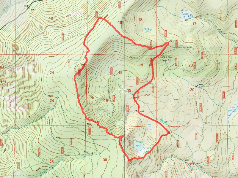
| Location / Trail | Buck Lake Trail - 701 |
| Weather | Cold, sunny at times, overcast others |
| Hiking Buddies | Zack |
| Start / End | 10:20 AM – 3:15 PM |
| Distance / Elev | 6.7 miles |
We got to the trailhead a little after 10:00, and found just a little bit of snow:

We headed up the short trail, and while I had planned on going to the lake and then going up, Zack had seen some segments of trail on previous hikes in the area, so we headed up the ridge off the trail about half way to the lake. We shortly found the first evidence of trail – a blaze and tread:

And a little farther up we found a very old cut log:

We continued up the ridge, mostly following blazes, but occasionally losing the trail in the snow. We finally arrived on top of the ridge, where the terrain flattens out. This area has been cut extensively in the past, so the trail goes in and out of cut areas, making it difficult to follow (especially in the snow, since it obscures many clues to the trail). There is also a tremendous amount of blowdown in places, making traversal quite difficult. Here is what it looks like on top in one of the easier to traverse spots:

In one particularly well maintained section, we did find some interesting artifacts. The tread was discernible and blazes were plentiful, and someone had worked on cutting out a number of downed logs. We also saw these “diamonds” along the way – Red, blue and one yellow one:

Our guess as to the purpose of these was to mark the trail for winter use – maybe snow shoeing or cross country skiing, but that was just a guess. They were high up on the trees, maybe 10-12′ high, placed at regular intervals marking the trail.
When we got up higher (we actually got up to about 4800′ in places), and got into some of the cut areas, the snow we getting a bit deep, and any semblance of trail was almost impossible to see. We were soaking wet from being rained on (melting snow from the trees) all day long, and decided to cut our losses and take the roads back rather than trying to go back the way we came. We figured it would be easier and much faster – I think that was a good call. We headed over to the 160 spur and hiked down to a point where it looked like it would be easier to go thru the woods. That also turned out to be a good call – in the uncut trees the snow was almost non existent and the underbrush was very easy to walk thru. We walked uphill back up to the flat area and then headed down the “nose” back to the 240 spur. On the way down, we encountered 3 or 4 of these rock outcroppings, which were really interesting. Here is the largest of the 4:

These would be interesting to explore – I think this one in particular would yield a nice view from the top. We didn’t want to climb it with all the snow on it. An adventure for another day.
We soon came to the 240 spur and headed back down to the trailhead. That was easy walking and we quickly made it back to the trailhead, and a warm truck. A stop at Fearless on the way home made for a great end to a great exploration. Probably the last high elevation one for this hiking season. This trail will stay on my list of “todos” for next year, for further exploration.