
| Date | 9/2/2017 |
| Location / Trail | Old Buck Lake Trail - 701 |
| Weather | Sunny and Hot |
| Hiking Buddies | Kirk, Ollie and Thor |
| Start / End | 9:25 AM – 1:00 PM |
| Distance / Elev | 5 miles |
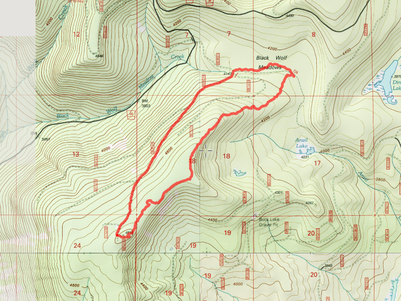
Unfortunately, I didn’t take many photos on this trip. The forecast was for it to be almost 100 degrees and we started early to try and beat the worst of the heat. We left home about 7:45am and got to the trailhead a little after 9. We had a bit of a surprise – Road 5810, which takes you to Buck Lake was closed due to logging activities. Even though nothing was happening today, the road was still closed completely, right after you got onto 5810. So, we looked for an alternate route. We decided to head up the road we bailed out on last time – the 58-160 spur – and kind of start where we left off last time. We weren’t exactly sure how the day would progress – we thought maybe we would go back to Buck Lake if we had time.
We quickly found what looked to be something like tread. I think it was what we were following last year, however it looked very different since there was no snow on the ground. We continued north thru the clearcut, following (at times) what looked like it could be tread, and other times just taking the easiest route. We got thru the first clearcut and spread out, looking for signs of tread and/or blazes. We found intermittent sections of tread – in some spots it wasn’t too bad – well blazed and somewhat distinct tread. But it never lasted too long. Either the blazes and/or tread dried up, or we hit another clearcut, where any signs of tread completely disappeared. I think we went thru 4 or 5 cut areas. A good shot of one of the good sections:

We continued north, looking for tread and blazes in the uncut areas, and just tried to get thru the cut areas as best we could – usually going along the east edge of the cut – it usually seemed there was a somewhat open area there. In one of the cut areas, we got this cool shot of a hazy Mt Hood (I thought it would be worse due to all the fires):

It was beginning to get rather warm (especially in the cut areas) and the dogs were getting hot so we stopped in the shade and all drank some water. Kirk snapped this great picture of Thor and Olle cooling off in the shade – they really have fun together:

After heading north and not finding a lot of recognizable tread, we knew we were getting close to the Anvil Lake trail. We spotted a flag, and found some tread. And then another flag, and some more tread. We didn’t backtrack to find the trail, but we did find out where the trail appears to have met the Anvil Lake trail – right at the post with the Blackwolf Meadow sign. This is the Anvil Lake trail as it heads thru Blackwolf Meadows:

We stopped in the shade there and decided what to do. Neither of us wanted to go back the way we came, so we decided to head back down the Anvil Lake trail to the 160 spur and walk back to the truck that way. It looked to be about 2 miles or so back to the truck, so that seemed like a good option, as it was starting to get really hot. We wanted to get done by noon or 1 and it was already noon. We made good time back to the truck and then packed up and headed out.
On the way out, we had been talking about Cot Creek (I’m not exactly sure why), but I thought we could drive up to see the old collapsed bridge. It wasn’t too far out of our way, so we headed up. Interestingly enough, the 4635-120 spur road that heads up to the bridge has had a lot of roadwork done on it. New gravel, grading, and a bunch of trees cut off the edges of the road. Looks like the are prepping for doing some more thinning work up that road.
Here is a photo of the old Washed out cot creek bridge as we saw it today:

Contrast this to 2008 – it has grown in quite a lot since then:

A wonderful day in the woods – it was good to get out and escape most of the heat. Even though we didn’t find a lot of that old trail up high, it was still neat to try and find it.