
| Date | 10/28/2017 |
| Location / Trail | Plaza and Salmon Mountain Trails - 783, 787 |
| Weather | Sunny |
| Hiking Buddies | Kirk, Ollie and Thor |
| Start / End | 10:20 PM – 5:05 PM |
| Distance / Elev | 10.25 miles |
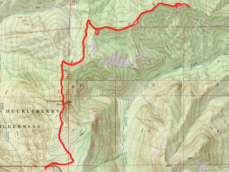
We headed up a little earlier than usual, and made our way down the pothole laden 4610 road to the east end of the Old Baldy trail. The Plaza trail actually starts here – you take off from the trailhead and in about 50 feet the Plaza trail heads east for a bit (to the old Plaza Guard station) and Old Baldy heads west.
We parked, got ready and headed out. I remembered to bring Thor’s backpack so he could carry his own water, etc. Here he is all ready to start the day:

We headed out, heading pretty much east until we got to the old Plaza Guard station location. About the only thing noticeable now is the old fireplace:

We looked around a bit and then headed up the trail. At this point the trail turns north, heading up to Sheepshead Rock and beyond. We got to Sheepshead Rock pretty quickly, and found a side trail that headed up to the small, rocky area on top of the rock. We got probably the best views of the day from this point, however I neglected to take a photo of the rock itself. It was a pretty unique looking rock. Here is a picture of Mt Hood from the top of Sheepshead rock:

And here is a 360 Photo from the top of Sheepshead Rock that Kirk took (mine got messed up somehow).
After soaking in the views for a bit, we headed back down and then continued north until we got to the junction with the Salmon Mountain trail (the marker sign has obviously seen better days):

And on the way up we saw a half dozen or so old phone line insulators along the trail that went up to the old lookout:

Shortly after the junction, we headed offtrail to get to the plane crash site which occurred in 1966. Here is part of the debris field of the crash – the debris field was actually much larger than I thought:

We explored the debris field a bit and then realized it might not have been a great idea to let the dogs run around – there was LOTS of gnarled metal on the ground – we were concerned that one of the dogs was going to cut their paws. We walked back out of the main debris field to make sure the dogs didn’t get hurt, and then headed back up the hill to the trail. It was still pretty early, and it didn’t look like it was too far to the lookout, so we continued east up the trail. Partway up, we saw these remains – we couldn’t figure out what it could have been. It was kind of small for an outhouse – we thought maybe the phone line terminated here, but we saw insulators farther up the trail, so what it was remains a mystery – some sort of box probably about 30″-36″ square:

Here is kind of typical tread on the Salmon Mountain trail-the trail guide says the tread disappears, but it seemed to be pretty good the whole way – but maybe I’m just used to hiking abandoned trails and this wasn’t as bad as those are:

And a bit farther up the trail, we found a ribbon from the recent hiker search in the area (just last week-thankfully he was found alive and well):

After some odd junctions on the trail, we finally made it up to the old lookout site on Salmon Mountain:

We found out that the trail location on the map is wrong. The trail actually goes below the summit, over to the east, and then switchbacks to the west to get to the summit. Apparently there is a cliff on the east side that is pretty much impassable. It was rather small up on top, and only had two footings there. Kirk took this photo of me and the dogs at the lookout (I was sitting on one of the footings):


We ate lunch at the lookout site and enjoyed the sunshine and the views for a while. After a while, we decided we should head back and then went back down the way we came. When we got to the switchback at the bottom of the hill (where it switchbacked back west up to the lookout), Kirk wanted to see if there were views on the second peak – the switchback was kind of in a saddle between the two peaks. There was a faint trail that headed up, so we followed it up to the high point, but there was really no views, just a small meadowy place where the faint trail seemed to kind of die. So, we headed back and then headed down the trail. We still had a long ways to go back and by this time it was almost 3:00.
On the way out, I had forgotten how up and down this trail was – or maybe I was just tired. It seemed like there was a LOT more UP on the way back than I remember.
We got back to the trailhead a little after 5:00 and found another vehicle parked there – we were guessing they must have been hiking the Old Baldy trail. We packed up and headed out.
On the way out, driving the 4614 road, a lone hunter was along side the road with a deer. He flagged us down and asked if we could help him load it into the back of his minivan. We did, although Kirk got some blood on him while we were loading it. It was kind of an interesting way to end the day!
We capped off an almost perfect day of hiking with dinner at Fearless.