
| Date | 12/9/2017 |
| Location / Trail | Switch Creek Trail |
| Weather | Sunny and Cold |
| Hiking Buddies | Kirk, Zack, Ollie and Thor |
| Start / End | 10:30 AM – 3:50 PM |
| Distance / Elev | 6.8 miles |
It had been something like 5 years since I’d been on the trail, so I had to try and remember some of the more obscure parts. Fortunately, I had a track from my last visit that helped us to stay (mostly) on the trail. We headed up from the parking area on road 46 where it was somewhat windy – down by the reservoir it was REALLY windy, but all up and down the Clackamas Gorge it was windy. The wind made the air temperature feel even colder – it was below freezing and there was frozen frost on road 46 in quite a few places, so driving was a bit tricky.
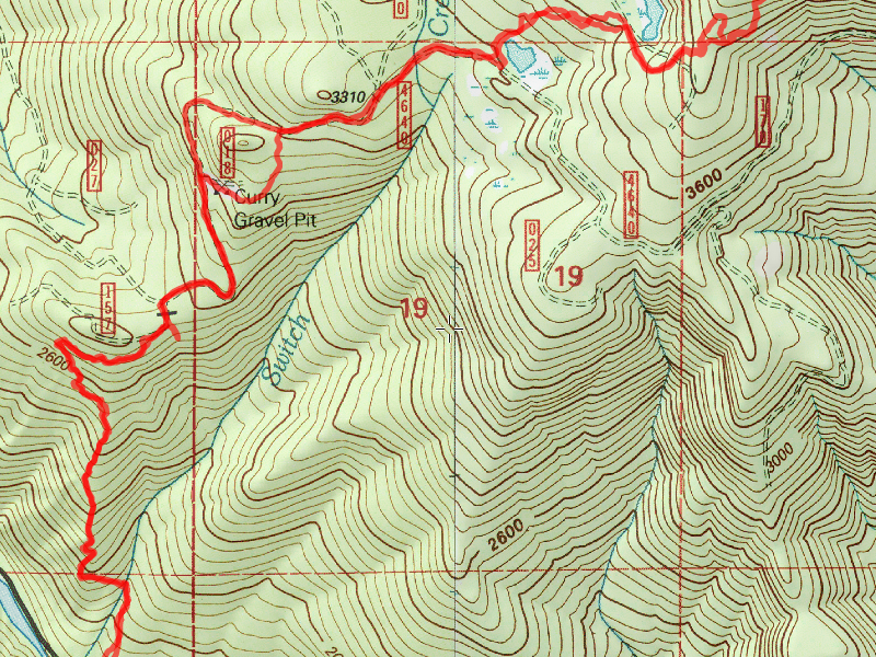
After getting ready (quickly due to the cold temps), we headed up the old spur road which is the beginning of the trail. It is still reasonably easy to follow, however the small trees are growing in in spots. We shortly got to the creek crossing and picked up the trail on the other side. That was not very easy, since there were quite a few rather large logs that had fallen, many right in the tread. We made our way thru that mess, and a better trail emerged after that (at least for a while). It wasn’t too long after the creek crossing where we ran across the first grisly/gross/interesting find of the day – a dead blacktail deer – and a pretty large one at that – Zack said it was a “4×5” – a 4 point buck with a smaller point near the head which was the “5”. He said that was a REALLY large deer for the Clackamas area. Something had eaten a large portion of it, but it was still pretty fresh. We couldn’t tell if this was a bad shot by a hunter, or if it was a cougar kill. Warning – gross picture ahead:

After checking out that find for a bit, we continued up the steep hillside – sometimes VERY steep – losing the trail for a bit here and there – but someone has flagged most of it reasonably well – so we were able to re-find the trail easily. When you get near the top of the hill, you intersect a better, more established trail. This trail takes you up to the 4640 road. At the trail junction, eagle eyed Kirk found an insulator (the old map shows this trail heading back up to Oak Grove Work Center with the phone line):

We shortly got to the newly decommissioned 4640-157 spur – the one that took you to a hunter camp at the top of the hill. The section out to the 4640 road is very short and soon we were on the 4640 road, attempting to follow the road and a bit of cross country to head east:

After doing a short cross country route thru an old gravel pit, we soon crossed Switch Creek again:

And then headed up to a rather swampy little lake area where we had lunch. There were a few of these “birdhouses” – but I’m not sure what is supposed to nest in them. The hole is HUGE:

After eating lunch in the sun on the north side of the swamp/lake, we made another cross country route – pretty much directly east to the 163 spur road, where we passed another swampy/lake area and then attempted to find the old trail that headed east. We walked up the ridge, and thought we were in the right area, but ended up going too far north and came back down and finally found the old tread. It was on a VERY steep, unstable hillside, but it had good views to the south in a couple of spots. This was looking southeast towards Burnt Granite with Olallie Butte just to the left of it – Olallie was all white, although it didn’t show up too well in the photo:

We headed up a little higher, following the trail relatively easily, with a few spots that had kind of fallen away. This is what some of the better trail looked like up higher:

At some point, we talked about what our turnaround time should be, and we decided it should be 2:00 (since the days are pretty short). We got to a particularly indistinct area on the trail, and we weren’t quite sure where it went. At that point, it was 1:57, so we made that our turnaround spot. We headed back the way we came – I got another shot looking south/southeast with a cool shot of the fog/clouds hanging over the hills:

We went back the same way we came except for one section where we walked back the road instead of going cross country – it was all downhill and we figured it would be faster. Looking at our route, I don’t think it cut much distance off anyway. We pretty quickly got back down the hill and got to the van a little before 4:00. It was starting to get chilly again, so it was good we got there when we did.
We finished the day with dinner and a beer at Fearless. An awesome winter day in the woods! Oh, and we never put on our snowshoes – we got to almost 4000′ but the snow was never deeper than 3-4″. so it turned out we didn’t need them after all!