
| Date | 6/13/2020 |
| Location / Trail | Rho Creek Trail - 569 |
| Weather | Overcast with periods of rain and sunbreaks |
| Hiking Buddies | Kirk, Ollie and Thor |
| Start / End | 10:45 AM – 5:00 PM |
| Distance / Elev | 9.4 miles 2200 ft elevation |
We headed up the trail and soon saw evidence of recent maintenance:

A little farther long where the trail gets very close to Rho Creek we got this great view of it:

And a little farther we got to one of the rough spots – the crossing of Tumble Creek:

We crossed the creek on the big log and continued – there is a switchback just past the crossing and the trail starts climbing more aggressively. At some point along the way, we encountered the relatively new, very large uprooted tree:

We had to climb above the tree to get around it, but it wasn’t too bad. As we continued up (this trail gains 2000′ of elevation, so it is almost constantly going up). Along the way, I noticed that the rhodies were starting to bloom:

As we proceeded up, we got to this old post, which marked the intersection with an abandoned trail (the Tumble Creek trail) that headed north:

Here is a piece of the abandoned Tumble Creek trail – we only headed up a tenth of a mile or so:

After exploring the Tumble Creek trail, we continued up the trail, crossed the beginnings of Rho Creek and then got into the clearcut. We passed Fadeaway spring and continued up thru the clearcut. Near the upper part of the clearcut, Kirk saw this really interesting orange fungus on a relatively young tree:

When we got to the top of the clearcut we had a decent view of Peavine Mountain:

We got to the 4672 road and headed across, up the next segment of the trail. The trail continues to climb thru large old growth until it gets up to the flat area surrounding Rho Meadow. As we were heading up this segment, we found these bones right in the middle of the trail:

Somewhere near these bones the trail flattened out and there were lots of downed trees. They were almost all small trees (2-6″), with a few larger ones, but there was a lot of them, many times piled on top of each other. It made passage rather difficult. We passed the post that wet southeast towards the meadow and continued down the trail. We finally came to the collapsed Ranger/Guard station at Rho Meadow:

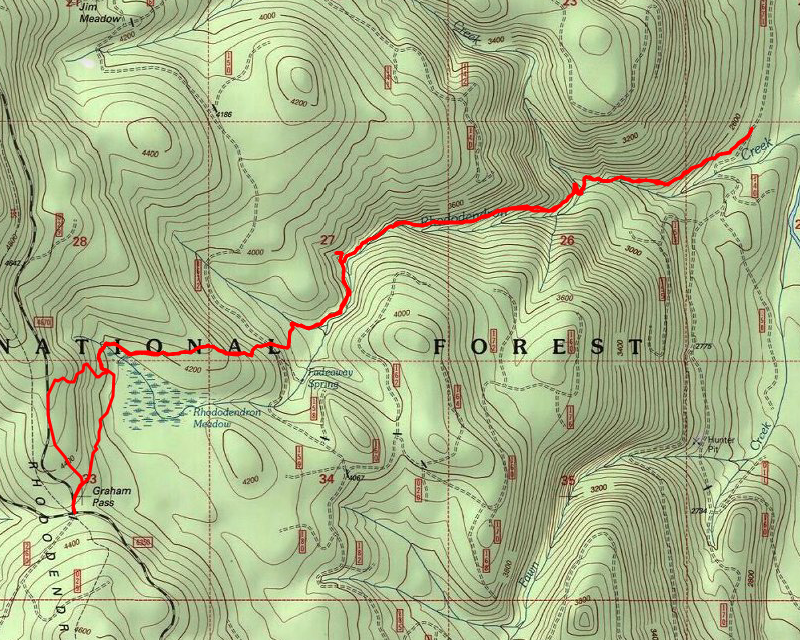
We stopped there for lunch – there were a few bugs, but not too bad. It threatened to rain on us, but we mostly stayed dry. After we ate, we decided to continue west, following some flagging – there were trails going all over the place from this spot – it was the center of a lot back in the day.
We were able to follow the trail for a while, but at some point lost it. We just continued in the same general direction and soon came to a decommissioned road. It does not appear on any maps but appears to be a spur road off of 4670. We saw a flag and a blaze across the road and we followed it – this was the continuation of the trail. We also found the trail on our side of the road – it appears we were a little bit too low. Anyway, we followed the trail across the road and quickly intersected the Rho Ridge trail. We walked this out to the junction of 4670 and 6350 – Graham Pass. From there, we pondered going up to Mt Lowe, but I’m glad we didn’t -that would have added another 5 miles to our day and it was already about 3:00. Kirk remembered a trailgoing east from a hunters camp just up 4670. So we headed up there. We found the camp and then started searching for the trail. We never did find it, but we did end up finding the Rho Creek trail just west of the guard station. We then started hiking back and soon found the junction with the trail we had been looking for. We apparently didn’t go north quite far enough to hit this trail. Kirk did a short recon trip up the trail and then we started back.
As we were heading back, Thor saw those bones again. He decided he wanted to take one home, so he grabbed it and was carrying it for a while. After a tenth of a mile or so, I guess he decided it was too heavy or something and dropped it.
The rest of the trip home was pretty uneventful – we were trying to make time since it was getting late. We only stopped once on the way back. We made it back to the truck about 5, just about as it started raining. It rained harder the closer we got to town. We were very fortunate with the weather.
We capped off the day with a trip to Fearless for a burger and a beer – it was the perfect way to end a great day of exploration.