
| Date | 3/27/2022 |
| Location / Trail | Clackamas Flyover |
| Weather | Overcast |
| Hiking Buddies | Kirk and Steve |
| Start / End | 1:45 PM – 4:30 PM |
The objectives for the day were as follows:
- South Fork Clackamas River (Old OC Waterworks)
- Fish Creek Divide, including Fish Creek Mountain
- Fish Creek – the old road going down the creek
- Cold Springs Trail segments
- Bull of the Woods Lookout (this burned last year)
- Whetstone Mountain
- Hawk Mountain
- Red Lake Trail
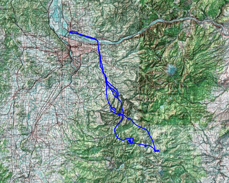
I have to say, navigating while we were flying was much more difficult than I expected – I spent a lot of time trying to figure out where we were and directing the flight. We weren’t completely successful with all the objectives, but we did get a LOT of very good pictures that we will be scrutinizing for quite a while. I’m so glad Kirk took so many photos!
The rest of this report is mostly going to be pictures, with a little bit of commentary in between them.
This was the hanger where the plane was where we started the day:
![]()
Kirk took a bunch of photos of the flight down to Estacada, but since this was all about the National Forest, I didn’t include any of them in this report. The first one I included was this of the Cazadero/Faraday Hydro complex:
![]()
Next was the North Fork Dam and Reservoir:
![]()
Soon, we got down to the South fork and we got this good photo of the South Fork Clackamas River Canyon – You can see road 45 to the right:
![]()
And the confluence of the South Fork and main stem Clackamas, along with the old scaling station (looking out over Big Cliff):

Circling around, we got to see where Memaloose Creek joins the South fork – a spot where there used to be a bridge for the OC Waterworks. That bridge appears to be gone:
![]()
Kirk captured this really good photo showing the damage to the main stem of the Clackamas canyon:
![]()
This is where the North Fork Clackamas comes in and it shows the 4610 road going up the hill (which used to ALL be forested with big trees):
![]()
It was shortly after this our pilot informed us we were going to have to turn around and land – there was a small door that didn’t get latched tightly and it was flapping around in the wind. We needed to land in Estacada, fix it and then take off again. This was us landing in Estacada:
![]()
On the way back into the woods, I got this good photo of downtown Estacada, showing where 211 comes into the south end of town:
![]()
After a bit more flying, we got to the confluence of Fish Creek and the Clackamas – there is green in places:
![]()
Soon after, we passed Wanderer’s Peak where you could see the South Fork drainage and road 45 on the other side:
![]()
We got a good view of Whalehead, with the new radio tower on it (but it is kind of hard to see in this photo):
![]()
Next up was Fish Creek Mountain – we didn’t get to fly over the peak where the lookout was unfortunately – unfortunately, it looks like it burned extremely hot up there:
![]()
Heading south down the Fish Creek drainage, we got a look up Pick and Music Creek (and Music Creek looks pretty green!):
![]()
Next up was East Mountain:
![]()
And a surprise – Surprise Lake – which doesn’t look like it burned too badly:
![]()
Continuing south, we got a good view of the ridge that caps the south end of Fish Creek – East Mountain, Thunder Mountain and Baty Butte
![]()
I don’t remember seeing this while flying, but I’m pretty sure this is Table Rock to the west:
![]()
We then flew down to Bull of the Woods to try and get a view of the burned lookout and got a good view of Pansy Lake which doesn’t look like it burned:
![]()
And Lake Lenore, which has been hammered by 3 rounds of fire now – it does not appear there is anything left around it:
![]()
And after a couple of circles, we got a good look at the burned out BOTW Lookout:
![]()
![]()
Once we got our good look at BOTW, we headed east over to Hawk Mountain and got a good view of the cabin there and how close the fires got:
![]()
![]()
Kirk snapped this great view of the Breitenbush Valley with road 46 heading thru it:
![]()
At this point, we flew over the Red Lake Trail and the lakes in the area (Red, Averill, Wall, Sheep) – you can see Fish Lake in the upper left and Olallie Lake in the upper right – while parts of this burned pretty good there are some significant sections of green still present:
![]()
Here is a view of Olallie Lake and points East – this all burned pretty good as part of the Lionshead fire:
![]()
And here is Fish Lake to the left, Lower and Gifford Lakes and Olallie Lake to the right – Olallie Butte is standing guard over it all in the background:
![]()
It was about at this point we realized we should probably head back. We headed back north and Kirk caught a great picture of Sisi Butte (which we climbed last year):
![]()
A little farther north, We got this good view of the Timber Lake Job Corps, Ripplebrook and Frog Lake up on the hill:
![]()
And then a shot of Fish Creek Mountain from the east side:
![]()
As we were making our way back, we decided to try and get some more views of the Fish Creek area – We believe this is the landing off the 4550-130 spur – what we called the shortcut:
![]()
![]()
South Fork Mountain and Memaloose Lake – this one might need to be a TBD as I’m still struggling with exactly what this picture is:
![]()
Lastly, a good picture of the scope of the devastation from the Riverside fire:
![]()
After flying around South Fork Mountain a bit, we started our way back to Vancouver. It only takes about 20 minutes to fly from Vancouver to Estacada.
The GPS said we flew about 250 miles in 2.6 hours – pretty amazing! You get a very different perspective from the air and it was very interesting to see the forest, even if it was from afar. I’m looking forward to the day we can actually get out there and explore some of these burned areas.
A great day out on a very unique experience.