
| Date | 6/27/2022 |
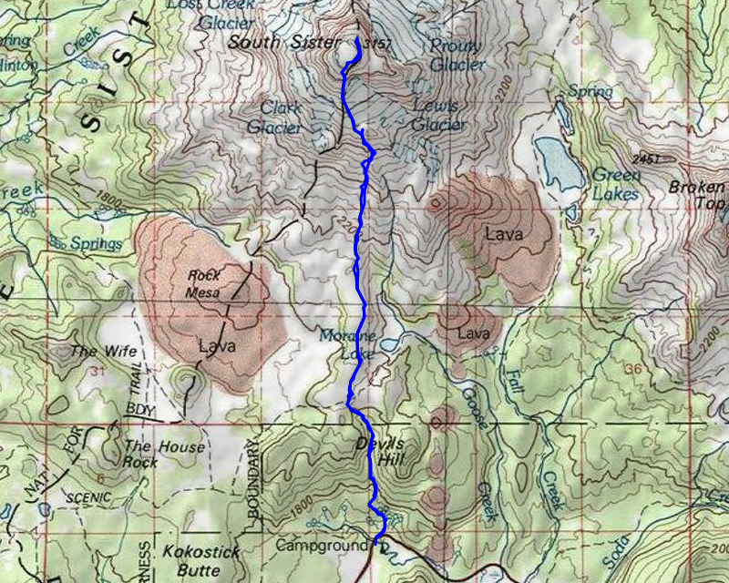
| Location / Trail | South Sister Summit |
| Weather | Sunny |
| Hiking Buddies | Carly, Nicholas |
| Start / End | 7:30 AM – 6:05 PM |
| Distance / Elev | 11.5 miles 5200 ft elevation |
As we were driving in, I saw snow along the loop road, which surprised me since it was late June. I really didn’t think we would be able to make it all the way up to the summit given the snow, but I was willing to try. We started out in the parking lot, crossed the road and headed up. The beginning of the trail, although wet in places had no real snow:

It wasn’t very far until we got into full snow coverage – I’m guessing a half mile – no more than 3/4 mile from the trailhead, we were into this – deep and getting deeper quickly:

We climbed up out of the basin up to what I call the Moraine Lakes basin where it flattens out a bit for a little while. This is what it looked like up there:

As we proceeded up, we could see our objective but we still had a long ways to go:

As we headed up, we saw a still very frozen Moraine Lake off to the east:

We continued up, walking mostly over compacted snow most of the way with occasional breaks on hard ground. We made quite a few rest breaks along the way, but continued on what I thought was reasonable pace. This was our view from maybe half way up the hill – pretty impressive but it kept getting better:

We continued up thru the snow – while the trail was not visible for the most part, we mostly followed others footsteps. In this picture you can actually see a trail marker (the stick in the cairn to the left of Nicholas). We basically followed the route of the trail, but at times I think we took a more direct route – many places we literally were walking straight up hill:

A little farther up the mountain we encountered this very interesting section. It looked like there had been an avalanche over the winter – the ground was VERY disturbed and it was tough navigating thru this area:

Almost 5 hours into the trip, we arrived at the lake at bottom of Lewis Glacier where Carly and I filled up our water and had a short rest break:

The view from this lake is pretty impressive:

We were pretty tired at this point but decided to continue on to see if we could make it to the top. We were starting the last push to the top – the hardest part of the trail I think:

The ground is very unstable and loose and it is very steep. Going down is almost as hard as going up due to the instability and angle.
It was in this area where we started to see what I called rivulets where glacier melt was carving little streams down the side of the mountain. It was creating havoc with the trail. I got fascinated watching the gravel get carried down the mountain – I took a short video of it, but it just kept repeating over and over and over – it was mesmerizing to watch:
Looking up ahead, you can see some of the people ahead of us way up in the snow near the top – they were very close to the summit:

We continued up until what looked like another avalanche area, and then headed up the base of the snow melt line which angled up. This area was by far the hardest and slowest portion of the trip. Carly did a great job leading us the entire way. In this section it literally was a step by step ascent. Kick in a foothold, step up, get stabilized and then repeat – over and over and over. I thought I had taken a photo in this area but I guess I forgot to unfortunately. I was pretty focused on the step by step nature of this segment of the climb.
We finally arrived at the summit at which point Nicholas needed to stop – one of his quads was cramping up pretty badly. He stayed on the south rim while Carly and I headed over to the true summit on the north side. That was a much more difficult trip than I had anticipated as well. There was too much snow to take the real rim trail, so it was a lot of sidehill walking in the snow to get to the summit. We finally arrive there and I captured a few pictures – Middle and North Sister from the summit:

The Lakes on the NE side of the mountain – one of them we camped at in 2019 when we climbed Middle Sister:

Broken Top which we climbed on that same trip:

By this time it was getting close to 3:00 – we had spent almost 8 hours getting to the summit. It was a bit chilly up there with the wind as well. We didn’t spend too much time up there. I took a few pictures and Carly pulled out her good camera and took a few photos as well. We met the group we had been leapfrogging all day long and were told that we were “a bunch of badasses” for being able to get up to the summit in those conditions (that made me feel pretty good honestly). We then headed back to Nicholas who was resting, all bundled up. Fortunately, his quad was feeling a lot better. We ate a few snacks for the trip back down and then started our descent. The trip back down was quite a bit faster than the trip up. The upper sections where it was steepest were difficult, but we managed to get thru them with no issues. Once back on the loose screen section below the snow, it was still pretty slow going due to the steepness and looseness. Once we made it down to the lake below Lewis Glacier it got a little easier.
There was a portion below the lake that was bare ground (including one of those avalanche sections) which we got thru. Once past that, we were back to mostly snow again. We wanted to make good time down and have a little fun, so we did several sections of glissading, which made for a very fast descent – and also a lot of fun. After the glissading sections we were back to walking in the snow, but at least now it was mostly all downhill. We got to the junction with the Moraine Lake trail and then shortly headed down the hill for the last push to the parking lot.
This section seemed to go on and on and on. It was only supposed to be 1.4 miles but it felt like 3 miles. I think we were all tired and just ready to be back at the car. We made it back to the car a little after 6:00pm – We had been on the trail for 10.5 hours! Fortunately, the trip down only took about 3 hours, otherwise we would have been be hiking in the dark.
We made it back to the rental house a little bit after 7, had a shower, dinner and an early bed time. We were all pretty tired, but I felt really good that I was able to do this trip. It was WAY harder than the last summit I did on South Sister – I think it was the hardest day trip I’ve ever done to this point, but I’m really glad I did it.
A couple last items of note – while we had put sunscreen on at the trailhead, Nicholas and I didn’t re-apply it at any point during the day. With the bright sunshine and all of the snow, we both got pretty good sunburns. I was fortunate that Carly had an extra pair of sunglasses – part way up the mountain I was struggling with how bright it was and she loaned me an extra pair of sunglasses that I put over my glasses. I’m sure I looked ridiculous but they really helped a lot with the brightness.
A truly epic day on the mountain – even better was that I was able to share it with two of my kids.