
| Date | 9/6-9/9-2022 |
| Location / Trail | Alpine Lakes Wilderness Backpack |
| Weather | Sunny |
| Hiking Buddies | Carly, Kirk and Otis |
| Distance / Elev | 31.4 miles 11,000 ft elevation |
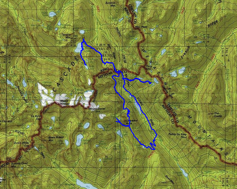
The plan was to do a modified loop – basically a loop with an out and back for each night associated with it. It was a challenging plan, but we were all up for it. The plan was this:
- Day 1 – 6.2 Miles – Deception Pass Trailhead to Robin Lake – 3200′ Elevation
- Day 2 – 7.9 Miles – Robin Lake to Jade Lake – 2500′ Elevation
- Day 3 – 11.1 Miles – Jade Lake to Peggy’s Pond – 3200′ Elevation
- Day 4 – 5 Miles – Peggy’s Pond to Cathedral Pass Trailhead (right next to where we began) – 300′ Elevation
Total: 30.2 Miles, 9200′ Elevation
Actual: 31.4 Miles, 11,000′ Elevation
Carly had also planned “side trips” if we wanted to do them. I wasn’t sure I’d be up for them, as this was challenging enough. I would see how I felt to see if I thought I could do any of the side trips. Here is what happened:
Day 1 – Deception Pass Trailhead to Robin Lake
We started out really early from home, leaving at 5am. The idea was since the first day wasn’t terribly long, we could just meet at the trailhead around 11:00 and head out. Fortunately, that worked out OK even though the day turned out to be much more difficult than we anticipated.
The first weird thing of the trip happened just north of the Columbia river. Highway 97 takes a weird little jog at one point. You have to stop, take a left, then take a right. At the stop sign, something had been spilled on the road. When I went to take off, I spun my tires. Shortly after that, there was this terrible stench in the truck. We were kind of expecting it to dissipate after driving for a while, but it didn’t get a whole lot better. We stopped in Cle Elum for gas, and I also paid for a car wash, hoping it would help wash off whatever it was that got on my truck. It helped but it didn’t get it all off unfortunately.
We made it to the trailhead a little before 11, and Carly had texted us earlier that she was just a little behind us. We got ready, and in about 5 minutes, she showed up. We got all of our passes in place and headed out. We started at the Deception Pass trailhead and would be returning on the Cathedral Pass trailhead on Friday. The first portion of the trip was pretty easy – it was mostly level along Hyas Lake. At one point we got a good look of the lake and also of Cathedral Rock on the other side (which we would be going around on Thursday):

Partway up the trail, as we were beginning the gentle climb, we got a good look at Mt Daniel, which Kirk and Carly would climb early on Friday morning:

About 4 miles in, after the junction for the Robin Lakes trail, the trail changed dramatically. What had been a pretty good trail suddenly changed into a goat path. Heading straight up steep hills, filled with rocks and roots and just plain difficult. This continued pretty much all the way to Tuck lake – a sample of what it looked like-this had to be at least a 45 degree angle:

As we were climbing, there were some open spots. At one point, we got a good view of where we started earlier in the day – Hyas Lake way below:

We continued climbing – I struggled and felt like I needed to stop about every 10 feet – it was getting warm and the trail was just terrible – and dusty. Eventually, we finally made it to Tuck Lake, which is a very nice alpine lake:

We stopped here for a bit to rest and then continued the climb to Robin Lakes. As we were leaving Tuck lake, we got a good view of Tuck’s Pot, a small lake just south of Tuck Lake:

And we got a better view of Tuck lake as well:

As bad as the trail up to Tuck lake was, the “trail” from Tuck to Robin lake was even worse. The trees were thinning, there were more rocks and boulders and the trail was steep in places and went up and down a lot. It was extremely difficult, especially at the end of the day with a full pack. After a lot of rest breaks, and “I think it is just above the next hill” moments, we finally made it up to Robin Lakes:

We scouted around a bit and setup camp for the night:

We had an excellent view of Mt Daniel:

After setting up camp, we made dinner. We didn’t have a lot of time to do much exploring. After dinner, we cleaned up and went to bed. We were all tired and had another challenging day ahead of us.
Day 2 – Robin Lake to Jade Lake
We woke up on Wednesday morning to a chill in the air, but we all expected it to be colder than it was. We were at almost 6200′ and expected it to get close to freezing but it never felt that cold. As we had another busy day planned, we made breakfast, cleaned up and then packed up and left. On the way down, I got a picture of what part of the “trail” looked like on the way down – rough and steep:

The descent was a bit easier than the ascent, but it was still hard on the knees and quads coming down because it was so steep in places. It took us probably two hours to get back to the Deception pass trail where we headed north to Deception pass:

This is an area where 5 different trails converge in a very short space. It was busy – every time we came thru, there were at least some people there taking a break. We didn’t stop, but took off on the Marmot Lake trail:

At the beginning of this trail, it is mostly level. It was in this area where there were TONS of huckleberries:

I was surprised there were still so many since this is an extremely busy area. I assumed people would have picked the bushes clean – but there were still lots of berries for us to enjoy. The trail continued for a while pretty level and at some point it started heading downhill, which surprised me – I had assumed that we would just take a leisurely grade uphill to Marmot Lake – but I was wrong. We continued down until we got to the outlet of a small lake (which we couldn’t see). We stopped here for lunch:

Kirk walked up the creek to see if he could get a view of the lake and got a view of a few Marmots sunning themselves:

After eating lunch, we continued down a bit until finally starting our ascent up to Marmot Lake. We passed thru some magnificent old timber which was a bit unexpected. We continued until we got to this neat spot where we crossed the outlet of Marmot Lake – there was a cool waterfall and an interesting crossing – not sure how they did it, but most of the water was going under the rocks, which made for an easy crossing:

We stopped to fill our water and then continued up to the junction with the Clarice lake trail. That trail continued north, to Clarice Lake and we swung around and headed back south. We encountered this sign – we quickly learned when we saw “hiker only trail” that meant it was going to get a lot rougher – most likely a lot narrower, more ups and downs and generally just a difficult trail:

Soon after that junction, we came to the second crossing of the outlet of Marmot Lake:

And soon arrived at the absolutely HUGE Marmot lake – it is over a half mile long and almost a half mile wide at its widest point:

We stopped at the lake for a short rest and then proceeded along the shore for a bit. The “trail” along the east side of the lake was rather rough, going up and down a LOT. We thought moving along the shore as far as we could would be a bit easier. After we couldn’t go any farther along the shore, we went back up to the trail and continued south. The trail takes many ups and downs, some parts were pretty good, some were pretty bad. It appears it gets no maintenance as there were a lot of downed logs. Once we got to the end of the lake, the trail takes a sharp turn up, heading up an outflow from the lakes above. I didn’t get a picture of it, but although it was steep, it wasn’t too bad. It was WAY better than the ascent to Tuck and Robin lakes. Once you get up the steep stream bed ascent, it flattens out into a very pretty meadowy area:

And you soon encounter “No Name Lake”:

And then, after a short climb, the stunning, appropriately named Jade Lake:

I’ve never seen a lake so vibrant in its color. The color comes from the sediment from the glacier on Dip Top Gap. After enjoying that view for a bit, we headed down to the area where there are campsites and looked around. There were quite a few people there. We found one and setup camp for the night:

Here is Jade Lake in the evening light, looking up to Dip Top Gap, which is one “side trip” Carly suggested – but we were all too tired to do it:

We made dinner, ate and cleaned up and by that time it was starting to get dark, so we went to bed, tired after another long and challenging day.
Day 3 – Jade Lake to Peggy’s Pond
Day 3 was supposed to be the hardest day – it had the most mileage and still a lot of elevation. My perception of it was that the first day was the hardest. Even though there was a lot of mileage and elevation, the trail condition and the grade of the elevation gain made it much easier than day 1.
We got up, got surprised by frost on the tents (and the ground), made breakfast and headed out. We tried to leave early due to the anticipated long day, but we only left like a half hour earlier than we had the day before. That turned out to not be a big deal though, since the trail was in such good shape we made pretty good time.
On the way down the Marmot Lake trail, we took a side trail to check out the small pond that fed the creek we had lunch at the day before (and where Kirk saw the Marmots) – it wasn’t much of a lake:

But there was a large meadowy area where people were camped:

We made pretty quick work of getting down the Marmot Lake trail and soon got back to Deception pass. This time, we took the PCT cutoff from the pass and headed down (I wasn’t expecting it to go down since we had a lot of elevation to gain). We headed south on the PCT, heading down. We crossed two feeders to the Cle Elum river – here is the first one:

Which gave us a pretty good view down the valley to Hyas Lake:

The second crossing was nothing, but the third one was the one that a sign warned about – a “dangerous ford” – this picture didn’t really capture it, but at higher water it would be a challenging crossing – most likely having to wade – today it was a pretty easy rock hop across:

Once across this crossing, the trail started its ascent. The grade was pretty good for the most part. It went in and out of the trees but for the most part was pretty good trail.
A little farther south, getting closer to Cathedral rock, it went thru a very rocky/boulder area – it was kind of interesting:

Looking up at Cathedral rock thru the boulder field:

A little farther up I got this interesting view of Cathedral Rock:

We soon got to Cathedral pass and continued over on the PCT to its first switchback down to Deep Lake. This was the point where the Peggy’s Pond trail took off. The beginning had a sign warning about a “hiker only” trail, so we were kind of expecting it to be rough. It was a lot rougher than we thought. A lot of it was basically a goat path – very narrow, steep in spots and don’t slip otherwise you’ll tumble down a VERY steep hillside. I didn’t get a picture of it though. I think I was just trying to get thru it after a long day of hiking. I do remember the last bit up to the lake was incredibly steep and dusty. I was tired and cranky, but we finally made it up to Peggy’s Pond:

We had a great view of Mt Daniel, which Kirk and Carly would climb the following morning:

We looked around for a while for a campsite – Carly said she found the perfect spot but someone else grabbed it. Again, there were quite a few people around the lake but were all dispersed around so it didn’t feel busy at all. This is where we ended up:

Otis gets cold easily when not hiking, so Carly puts her pad on the ground and covers him up with her sleeping bag. He was so tired he just crashed out while we setup camp.
We got to Peggy’s Pond a little after 5 and took a while to choose a campsite. Once we did, we setup camp, made dinner and went to bed as it was getting dark. The plan was for Kirk and Carly to get up at 5am the following morning and hike to the top of Mt Daniel while I stayed back in camp with Otis. Friday promised to be an interesting day.
Day 4 – Peggy’s Pond to Cathedral Pass Trailhead
Carly and Kirk woke up at 5am and headed out a little before 6 I think. It was cold (it froze again overnight), so I stayed warm and comfy in my sleeping bag. I slept in until about 7:30 I think. The hike up to Mt Daniel was estimated to be about 3 miles roundtrip and 2200′ of elevation – I was expecting it to take them 3-4 hours. Turns out both of those expectations were incorrect.
When I woke up I wasn’t quite sure if it was just foggy or if the smoke had rolled in, but after a while it was clear it was smoke, not fog. Here is what Peggy’s pond looked like in the smoke:

It wasn’t terrible smoke, but it was definitely making everything hazy. I guess the wind shifted overnight and brought the smoke in. Until that point, things had been pretty clear. Since I didn’t have a lot to do after I made breakfast and cleaned up, I took this better shot of our campsite, showing Kirk’s tent up the hill in the trees:

And I took this smoky picture of Cathedral Rock hovering over Peggy’s Pond:

I waited patiently for Carly and Kirk to return but the time just kept ticking. By 11:00, I started to get a little worried. I think they finally got back into camp a little before noon. It ended up to be a 5-6 hour trip, not a 3-4 hour trip. Part of that was because it was a 5 mile roundtrip, not 3. The view from the top wasn’t that great due to the smoke – this is what they saw – just a blanket of smoke with a few peaks popping thru:

Once they arrived back in camp, they packed up (I had already packed up all my stuff) and we left camp about 12:15. There was another trail going up to Peggy’s Pond that we didn’t take on the way in, so we decided to try that trail on the way out to see if it was better (it was marginally better). Along the way, we found the remains of either a cabin or shelter or something:

We continued out on Peggy’s Pond trail thru the highly exposed parts and soon got back to the PCT. The way out didn’t seem quite as bad as the way in, but I’m sure that is partially because we weren’t all tired out at the end of a long day.
Once back on the PCT, we headed back over Cathedral Pass and continued down. Part way down, we passed Squaw Lake:

A little farther down, we took the junction to the Cathedral Pass trail, which would be our last segment for the day. We were all looking forward to getting some real food and getting home to our comfortable beds and hot showers. The last couple of miles seemed to take a long time, but we finally arrived back at our vehicles about 3:00.
We cleaned up a bit, changed clothes and then headed out. The grading on the 4330 road we had encountered on the way in appeared to be done and it was in beautiful shape. We drove out to the town of Cle Elum (where we had gotten gas on the way in) and stopped at the Dru Bru for an early dinner. Cle Elum is where our routes home diverged so it was a good place to stop. We had pizza and beer and it tasted FANTASTIC after 4 days of backpacking food.
We said goodbye to Carly and headed home. Kirk and I powered thru the trip home – we didn’t stop at all and ended up getting home about 9:30 Friday night, tired but glad to be home.
Another outstanding backpacking trip. I wonder what trip #19 will be?