
| Date | 5/31/2008 |
| Location / Trail | Milepost 3 Trail |
| Weather | Partly Cloudy and in the upper 60s to low 70s |
| Hiking Buddies | Bodie (my dog) |
| Start / End | 11:30 AM – 3:30 PM |
| Distance / Elev | 5 miles |
Description of Hike:
I woke up this morning, the weather was cloudy, and the forecast was for probable rain. Since I wimped out the weekend before, I decided that I was going hiking no matter what. Then I was half way to Estacada, and it dawned on me that I forgot my rain gear! That didn’t deter me, however….I decided I would make do with what I had and was determined to hike today. Anyway, I found the trailhead for the infamous “Milepost 3 Trail” after a bunch of looking. I was a little farther up the road than I should have been. Everywhere I looked, the hill went almost straight up! Anyway, after a bit of searching, I finally found the trail. WHAT A BEAUTIFUL TRAIL! I wonder why it got abandoned? It is a bit steep in places, but it has a lot of beautiful points on it.

What looks to be genuine first growth old growth, some wonderful views from the talus slopes, and a very calming feel to it.

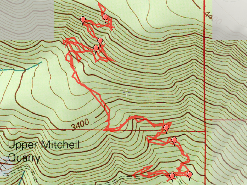
Unfortunately, I didn’t get a whole lot of pictures since the battery in my camera died part way through the trip. I missed getting pictures in my favorite part of the hike where it meanders through the beautiful old growth. There are a couple of pretty rough spots in the trail, but overall it was easy to hike. Most of the tread is easy to spot, however there is a lower section where it gets a little sketchy, and an upper section that is pretty nasty due to downed trees/branches and a bunch of overgrowth. I hadn’t planned on spending a lot of time tending trail, so I just brought my clippers and no gloves, and I clipped until I got blisters on the way up. On the way down, I tried to throw branches off the trail. It could still use a lot of TLC, but the hike is most definitely worth it, and pretty easy to follow as long as you pay attention to where you are going. Since I didn’t see flagging or a rock cairn at the trailhead, I stacked several rocks at the trailhead hopefully to make it a little more apparent for people to find. My GPS differed from the posted coordinates by a little bit. I was up the road a few hundred feet too far. It is just before the 3 mile point on 4635, probably no more than a tenth of a mile. My GPS recorded about 5.1 miles roundtrip, but it also recorded a bunch of searching in the beginning, so I think it would have recorded 2.4 miles up to the intersection of Rimrock. I couldn’t find Rimrock due to the snow, (it was a couple feet deep on the top of the hill). Anyway, a very enjoyable day up in the hills….. The trail is on Road #4635… The UTM coordinates at the trailhead are 10T 577761mE 4994293mN The trail starts out at 2742′ and tops out at 4256′ in 2.7ish miles where it T-bones the Rim Rock trail.
What looks to be genuine first growth old growth, some wonderful views from the talus slopes, and a very calming feel to it.
Unfortunately, I didn’t get a whole lot of pictures since the battery in my camera died part way through the trip. I missed getting pictures in my favorite part of the hike where it meanders through the beautiful old growth. There are a couple of pretty rough spots in the trail, but overall it was easy to hike. Most of the tread is easy to spot, however there is a lower section where it gets a little sketchy, and an upper section that is pretty nasty due to downed trees/branches and a bunch of overgrowth. I hadn’t planned on spending a lot of time tending trail, so I just brought my clippers and no gloves, and I clipped until I got blisters on the way up. On the way down, I tried to throw branches off the trail. It could still use a lot of TLC, but the hike is most definitely worth it, and pretty easy to follow as long as you pay attention to where you are going. Since I didn’t see flagging or a rock cairn at the trailhead, I stacked several rocks at the trailhead hopefully to make it a little more apparent for people to find. My GPS differed from the posted coordinates by a little bit. I was up the road a few hundred feet too far. It is just before the 3 mile point on 4635, probably no more than a tenth of a mile. My GPS recorded about 5.1 miles roundtrip, but it also recorded a bunch of searching in the beginning, so I think it would have recorded 2.4 miles up to the intersection of Rimrock. I couldn’t find Rimrock due to the snow, (it was a couple feet deep on the top of the hill). Anyway, a very enjoyable day up in the hills….. The trail is on Road #4635… The UTM coordinates at the trailhead are 10T 577761mE 4994293mN The trail starts out at 2742′ and tops out at 4256′ in 2.7ish miles where it T-bones the Rim Rock trail.