
Location of Hike: Bull of the Woods Wilderness - Twin Lakes and Silver King Lake
Trail Number: 546, 544, 573, 558
Weather during Hike: Sunny
Hiking Buddies: Carly
Hike Distance: Approximately 30 miles
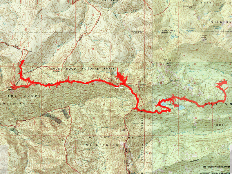
Day 1:
Trail 546 (Whetstone) to Trail 573 (Twin Lakes) to Twin Lakes – Camp
It time available, Take 573 to end and explore up and down 558 – Motherlode
At junction of 558 and 559, remains of Elk Lake shelter
Off 558, trail down to porcupine mine
North on 558, proceed near Mother Lode mountain
Day 2:
Back 573 to 546 and camp at Silver King Lake
If 573 trip not done, do that before leaving Twin Lakes
After setting camp at Silver King Lake, explore up Bagby Trail 544
Day 3:
Back to Whetstone trailhead
We started out on Tuesday, 7/29 about 10:30am at the trailhead for the Whetstone trail. The weather forecast called for rain, and it was getting increasingly cloudy, so I was worried about getting setup in the rain. We talked about it, and thought about camping at Silver King Lake on Tuesday night, but decided to press on and make it to Twin Lakes.

We got a little drizzled on, but made it to the lake before the rain got too bad. After dinner, we made a short trip down to the Lower Twin Lake to see what it was like. It had a fire late last summer and it had destroyed part of the trail and possibly the campsites there. The lake is smaller than Upper Twin Lake, but was still very pretty.


It drizzled most of the night and it was pretty wet when we got up on Wednesday, but the sun was starting to come out. We then hiked down the Twin Lakes trail to the junction with the Mother Lode trail (558), looking for the porcupine mine.

We didn’t end up finding it, but did find an old campsite. We also got VERY wet due to the brushy trail and everything being so wet from the rain. Since we had a long day of hiking ahead, we turned around, went back to camp, had lunch and packed up. We then went back up the Twin Lakes trail, up a section of the Bagby trail to the Silver King Lake cutoff. Silver King Lake is a little unique in that we had to hike UP to it. Typically, lakes are at the bottom of a hill, but this lake was set up on a high “ledge”. We had to hike about 200′ up from the Bagby trail, on a rather tough section of trail. We got camp setup and started hanging up wet stuff when 3 other hikers showed up.


Since there really was only one campsite there, we offered to share with them. We talked a bit and they started a nice fire. Carly instructed me on how to solve a rubics cube after dinner (freeze dried lasagna-yum!), and then we had chocolate pudding for desert. We played a little 5 card rummy and then turned in after hiking about 12 miles that day. We were pretty tired.
The third day, we got up early, made breakfast and broke camp. We were on the trail by about 8:00, wanting to hike in the cooler weather of the morning. The hike back up the trail up to the junction with the Whetstone trail is pretty grueling. It is a narrow, steep and brushy trail that gains about 700′ in a mile. That first mile took up about 45 minutes, and we were huffing pretty good when we finally got to the top. After that, the trail was a little more forgiving, doing gentler up and downs. We hiked to the junction that goes to the top of Whetstone Mountain, dropped our packs in the woods, and hiked up to the top of Whetstone Mountain. The view from the top is absolutely spectacular, having an unobstructed 270 degree view.

The top of the mountain is a large rock outcropping, so there are no trees up there to block the view. You earn the view, however. The trail is pretty steep, and gains something like 900′ in a mile. It was also pretty tough due to the many downed trees over the trail. I have to say it was worth the hike, however. The view is one of the best in the area, I think. Looking out over the uncut sections of the forest is simply beautiful. After enjoying the view for a few minutes and taking some pictures, we descended back down, got our packs, ate a little lunch, and then finished the hike at the truck about 12:30. Since it was still pretty early, we decided to take a detour on the way home, looking for the “bridge to nowhere” that I had recently heard about. Apparently, the story is that the USFS wanted to log the trees in one area, and they were trying to get the roads into it before the area could be designated a wilderness. The built the bridge, but before they could build any roads, the area was designated wilderness and no logging could be done. So, the bridge sits and goes straight into a hillside.

It is a very odd sight! Due to the road closure (road 63 washout), we had to take the long way around and it took about 1 1/2 hours to get to it. It was worth the drive, though!
All in all a great 3 days through some absolutely gorgeous country. Most of the area we hiked in was old growth and/or virgin forest.