
| Date | 8/29/2008 |
| Location / Trail | Table Rock |
| Weather | A Little overcast, but warm |
| Hiking Buddies | Bodie (my dog) |
| Start / End | 10:30 AM – 3:00 PM |
| Distance / Elev | 8.5 |
Description of Hike:
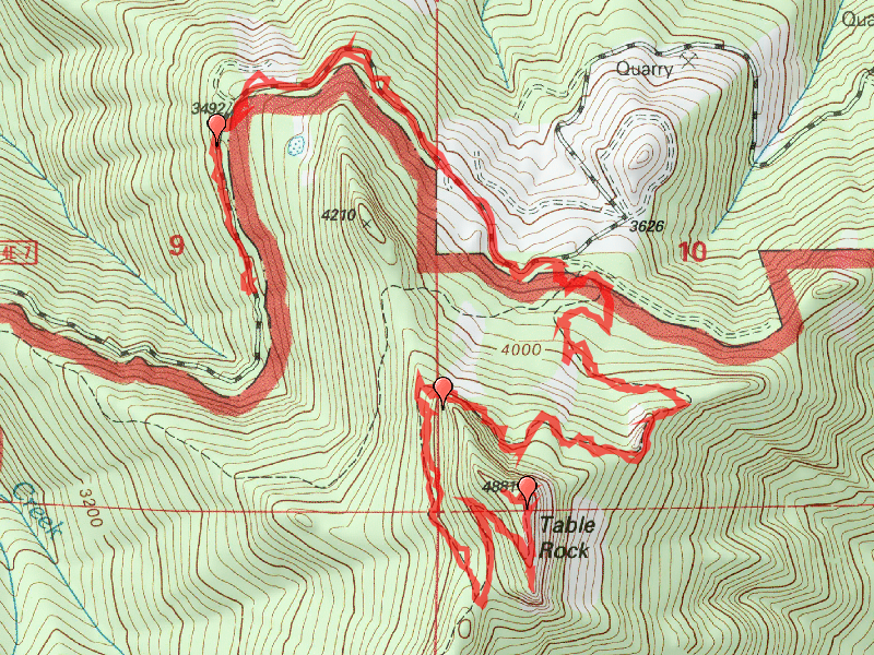
This was a day trip to the Table Rock Wilderness area, to hike to the top of Table Rock. I haven’t gone in this area before, and it sounded interesting. It was a relatively tough trip for me, especially the traversal over the talus slope on the north side of Table Rock. The trail there isn’t too good, and goes up and down and has poor footing.

The trail starts out on an old road closed by two landslides. You walk up the old road a little over a mile to the original trailhead and enter the forest. It is a nice trail that is well maintained and goes through some pretty forest. Even though you are gaining altitude, the grade is pretty easy . After about another mile or so, it exits the forest and you do the traversal across the north face of Table Rock.

After that, you re-enter the forest for another half mile gently going uphill most of the way. A small clearing and a junction takes you the last half mile or so to the top of Table Rock.

It is a rather windy path, but it does eventually take you to the top, where you see wonderful views. To the north there is a fair amount of clear-cutting visible, but to the east and south it looks very nice. This day, only Jefferson was clearly visible. Mt Hood was in the clouds, and 3 Sisters, 3 Finger Jack and Mt Washington are visible, but a little hazy. On the way back down, we passed a couple groups of hikers, and Bodie decided to get too excited and pulled me down the trail after they had passed, which made me fall and get a big raspberry on my arm…..No harm done, but he does get a bit excited about going hiking!

On the way home, I wanted to try and see the Pechuck Lookout, but my directions to it were not very good, and I later found out that it still requires a pretty long hike to see. I’ll go back and do that hike another time, possibly from the Rooster Rock trail.
The trail starts out on an old road closed by two landslides. You walk up the old road a little over a mile to the original trailhead and enter the forest. It is a nice trail that is well maintained and goes through some pretty forest. Even though you are gaining altitude, the grade is pretty easy . After about another mile or so, it exits the forest and you do the traversal across the north face of Table Rock.
After that, you re-enter the forest for another half mile gently going uphill most of the way. A small clearing and a junction takes you the last half mile or so to the top of Table Rock.
It is a rather windy path, but it does eventually take you to the top, where you see wonderful views. To the north there is a fair amount of clear-cutting visible, but to the east and south it looks very nice. This day, only Jefferson was clearly visible. Mt Hood was in the clouds, and 3 Sisters, 3 Finger Jack and Mt Washington are visible, but a little hazy. On the way back down, we passed a couple groups of hikers, and Bodie decided to get too excited and pulled me down the trail after they had passed, which made me fall and get a big raspberry on my arm…..No harm done, but he does get a bit excited about going hiking!
On the way home, I wanted to try and see the Pechuck Lookout, but my directions to it were not very good, and I later found out that it still requires a pretty long hike to see. I’ll go back and do that hike another time, possibly from the Rooster Rock trail.