
Location of Hike: Bagby - Whetstone - Battle Ax Creek Trails
Trail Number: 544, 546, 3369, 3339
Weather during Hike: Warm, but not hot - no rain - In the 70s
Hiking Buddies: Carly
Hike Distance: 17.9 miles
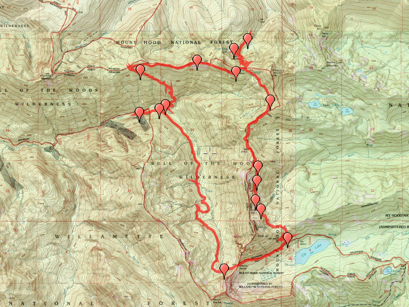
Day 1 was a relatively uneventful day, driving down the rough 4697 road to Elk Lake and beyond, up to the Bagby (544) trailhead.

Headed up the trail, gaining elevation for the first couple of miles, but not seeing anything too unusual. The forest is beautiful, with lots of old growth. When we got up close to a ridge, we ran into a lone hiker who had just encountered a bear while eating lunch. He said he saw what looked like a big German Shepard dog, but when he saw the whole thing, realized it was a BEAR. He made lots of noise, and I think the bear was as scared as he was and the bear ran down the hill. My guess is that he was being rather quiet eating lunch and the bear didn’t realize he was there. We got to Silver King Lake mid afternoon and set up camp and just relaxed the rest of the day.


The lake was beautiful with lots of salamanders and LOTS of fish jumping. I really wish I had taken my pole….I saw a rainbow trout swimming in the lake, but when some of them jumped out farther, it looked like there might be some cutthroat as well. It was really neat to watch the fish jump. Some of them were jumping REALLY high! Had dinner, cleaned up and went to bed early.
On the morning of day 2, we got up, ate breakfast and then packed up and headed out about 8:00. We went back down the hill from Silver King Lake and then went a little farther north on the Bagby trail to investigate “Howdy Doody Camp” as mentioned on the trail sheet. Not much to see, just a fire ring and a crude bench, but was somewhat interesting.

It also sparked a discussion with my daughter about who Howdy Doody was….Filled our water bottles from a small creek (rather than the lake, which tasted funny) and then proceeded back south along the Bagby trail, back up to the junction with Whetstone. Hiked across Whetstone, taking in the beautiful views from some of the rocky outcroppings along the way. When I looked south and told my daughter where we were going she asked “all the way down there?”.

It was a ways down to the creek…. We then continued losing elevation down to the junction with the 3369 trail which was the one where we lost a lot of elevation and eventually ended up at Battle Ax creek, which we crossed.

We ended up stopping there for lunch, and trying to dry out my boots – my daughter had one of those new “Off” doo dads to keep the mosquitoes at bay and it ended up falling in the creek when we were crossing. When I went to get it, I slipped and one of my feet fell in and got soaked. Oh well…We ate lunch, enjoyed the beautiful scenery of the creek, then packed up and started the long road back up. We had about 1800 feet of elevation to gain back….Right at the creek there were two really nice campsites.

Would make a great place to camp someday…Headed back up to the junction with the Battle Ax Creek trail (3369? – I don’t know) which is a really old road that was abandoned long ago and has reverted to a trail. We went west a bit to see the Shiny Rock mining company gate.


Going further it would take you all the way to Jawbone Flats, the old mining town which is still occupied with an environmental center now. We didn’t see much except for the gate and a sign – I guess there is a mine somewhere in there, but maybe we didn’t go far enough to see it. We didn’t want to go too far, since we knew how much elevation we had to make up. So we turned around and went back up the road, heading south. The road did a pretty consistent uphill all the way, gaining elevation at a reasonably gently grade most of the way. As we got closer to Beachie Saddle, the road got steeper. It was interesting that parts of the road still looked like a road, and parts were barely a trail, being very overgrown. We got to a point just short of Beachie Saddle, which offered a great view and we could see the point where I told my daughter where we would be later in the day.

Got up to Beachie Saddle, rested a bit after the long climb and then headed back to the truck (which was all downhill). I was absolutely amazed that they had cut a road through that area so long ago. It must have been a terrifying road to drive, especially in a truck!

After getting back to the truck, we found two other vehicles at the trailhead. We took our boots off and headed home. A short stop at Dairy Queen in Stayton for dinner and then home. It was a long day, a little over 12 miles and quite a bit of elevation.
All in all a good trip, however I was a little disappointed we didn’t see more interesting things – I guess that is what I get for doing a quickly planned trip. The trail from Battle Ax Creek to Beachie Saddle isn’t a great trail – there isn’t much to see, and on a sunny day would be quite warm. It is pretty open most of the way. I very much enjoyed the south end of the Bagby trail and Whetstone is always an interesting place to be. It would be interesting to see what that Gold Creek trail is like and the section between Jawbone Flats and Battle Ax Creek – That will have to wait for another day…..