
| Date | 9/12 - 9/14/2012 |
| Location / Trail | Eagle Cap Wilderness - Wallowa Mountains |
| Weather | Sunny and cold at night (below freezing) |
| Hiking Buddies | Carly |
| Distance / Elev | 30 miles |
This was intended to be our annual backpacking trip with my daughter last year, however due to unforeseen issues it had to be cancelled. I was very excited when she asked me if we could do this trip this summer. It certainly was a memorable trip. The trip started with some drama – we drove down the 7 mile gravel road to the trailhead, which wasn’t that bad (there are a LOT worse roads in the Clackamas district). We parked at the trailhead, got out of the truck, and heard a “sssssss” sound and looked down and the front drivers side tire was almost flat. Changed to the spare (which luckily still had air in it), and we went on our way down the trail. In over 10 years of hiking, I’ve never popped a tire on a gravel road. I guess there is a first time for everything. We debated on whether to drive all the way home on the spare (350 miles), but ended up deciding to stop on the way home at Les Schwab in Enterprise. Good thing – the tire was unrepairable due to the size of the slice, and we found out the spare was a little smaller than the tires, so driving a long distance would not have been a good thing. Long story short – ended up buying new tires there – the existing tires were almost down to the wear indicators anyway and ended up getting 6 ply tires (instead of 4 ply), which should help with any punctures down the road. They (Les Schwab) said they get a lot of punctures from gravel roads in that area. When we were walking back the road, saw lots of REALLY sharp rocks. On the way out the trip was a LOT slower to hopefully make sure we didn’t pop another tire since we didn’t have a spare. It was a rather “exciting” start for the trip….
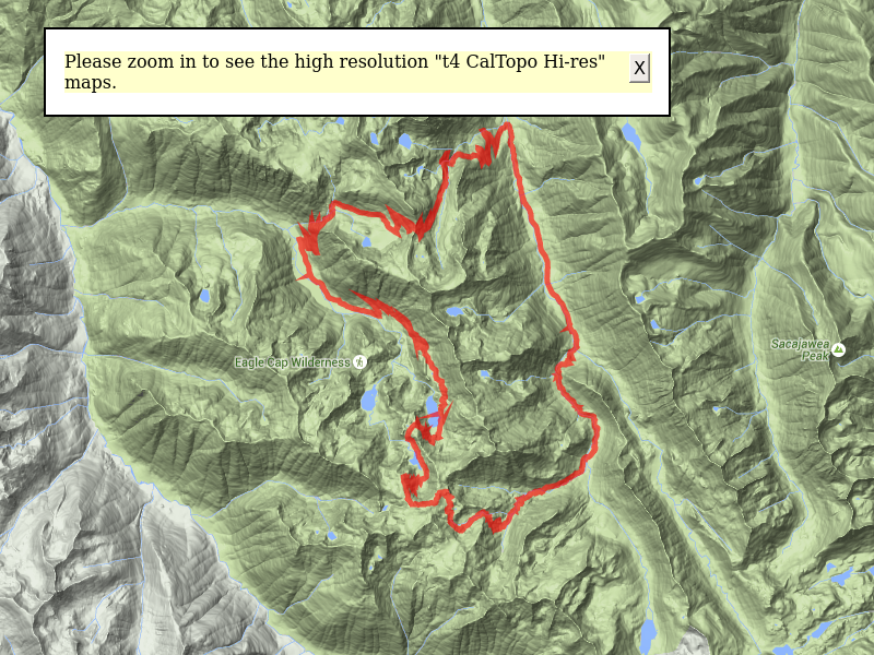
Once we got underway on the trip, we headed down the trail – day 1 was a challenging day – 11+ miles and 3000’+ of elevation gain, getting up to 8600′. We were trying to get most of the mileage done on day 1 and 2 so that day 3 would be a shorter day – we had to drive home after we got off the trail, so we wanted to make it a shorter hiking day. So, day 1 – we started around 9:30am – the first challenge was the first trail junction – a little confusing, but a couple of minutes of reviewing the map and we were on our way – across a concrete bridge over the east fork of the Lostine River. It then followed the west fork of the Lostine River up the valley. Since we had 3000′ of elevation to gain, we were climbing pretty much most of the day – until we hit the high point, where we quickly descended about 1200′ to our destination for the night – Steamboat lake. I’m getting ahead of myself here – the first couple of miles were rather non-eventful, although we did see icicles hanging from a tree in the river on the way up!

Once we got to the next trail junction (there are a lot of trails in Eagle cap!!!), we passed a horse camp and then got to our first “ford” – I was able to rock hop across, but Carly had to put her sandals on, but the water wasn’t much more than ankle deep – earlier in the year it would be calf to knee deep. Either way, the water was still COLD. We then proceeded to do two more fords, but both of them were rock hops at this time of year. We were prepared for deeper crossings, but the water level was down considerably at all the water crossings.
After the first ford, we continued up (the direction for most of the day) to another plateau where we had some nice viewpoints and was at the base of a large rockslide. A little farther up the trail, we came to another crossing of the creek and we decided to have lunch there. It was a great place to fill up with water and rest a bit before we continued our climb.

After the creek crossing, we crossed a rather large meadow and then proceeded up another series of switchbacks, climbing above the meadow. After climbing for a while, and passing a small waterfall (Elkhorn creek I think), we got to yet another meadow with a meandering creek. We stopped in this meadow for a rest and saw a cute little family of chipmunks next to the creek. They had quite an underground lair of tunnels!

After a short rest we continued through the meadow and then started up again. This continued until we came to yet another meadow at the top of that hill. We crossed that meadow (which is probably pretty wet in the spring, although it was dry when we went through), and then continued up a little farther to our highest point of the trip – 8600′. There was still snow in spots at this elevation, but the trail was clear. It gave us a great view of swamp lake and we got a preview of the switchbacks we would soon be travelling down in order to get to swamp lake.

Once we rested a bit after that LONG climb, we started down the long switchbacks down to Swamp Lake. There were some interesting “tufts” in the swampy areas in the south part of the Swamp Lakes basin. The trail had a path built over this swampy area, and then passed along the east side of the lake in the rocky areas. We stopped here to admire the lake for a bit and rest, and the proceeded past the lake and down another series of switchbacks. Just past the lake, we saw a pair of deer grazing. As soon as they saw us they took off, but it was neat to see them. After the deer we went around a small peak and then went down another series of switchbacks down to Steamboat Lake. The Steamboat Lakes basin is similar to Swamp Lake, but the lake is a little larger and there were better campsites. We were at about 7400′ in elevation. There was no one else at the lake, and we walked around to find a good campsite. We settled on one a little ways from the lake, near a couple of large granite outcroppings – one which had been used as a fire ring at some point. Fires were prohibited in this area, so not sure why people were using it for a fire ring. Maybe the prohibition is relatively new. After making dinner and getting things cleaned up, it was starting to get dark – we were tired so we turned in early – about 7:30. We both slept (more or less) until the sun came up the next morning – about 6am. It was COLD. It had frozen overnight – there were ice crystals in places were there was moisture, so I’m sure it got below freezing that night. We both stayed warm in our sleeping bags.

Once the sun came up, we made breakfast, cleaned up and got our our way to our next destination – about 11.5 miles, 2400′ of elevation gain – a campsite in Brownie Basin next to Bowman Creek. Our plan was to have the first two days be harder so we could get done earlier on the third day since we had to make the 6+ hour drive home after hiking out – we wanted to get as early a start as we could. The beginning of day 2 was pretty much all downhill, although we did have a short bit of uphill right past the lake. The rest of the downhill was pretty consistent and well graded, but it was unrelenting. We did have to lose over 2000′ of elevation though. We weaved our way through various different forests, ranging from the scraggly pine, to smaller fir, to some sections that looked very similar to forests in the Willamette valley (very dense, big trees). We switchbacked down the hills, crossing water quite a few times. One “creek” we must have crossed 4 or 5 times on the way down as we switchbacked down. When we finally got down to the bottom, it was a nice forest where the trail pretty much followed a nice creek. We followed the creek for a bit and decided to have lunch and water/rest up for the upcoming uphill sprint. We also met a lone hiker with her dog and asked about trail conditions up the way. We would need to gain about 2400′ before our destination for the day. After lunch, we saw the North Minam Meadows. They are HUGE! Although you can’t really appreciate the size of them until you start climbing out of the valley. The trail followed the east side of the meadow, but kind of hid part of it. Once you get to almost the north of the meadow, a trail junction takes you east, switchbacking up the valley wall, sometimes rather steeply. As you ascend, you can really see how big the meadow is. When you get higher, you get a GREAT view of the North Minam River valley.

As we continued up the trail (UP the trail), we got to another small creek crossing and another meadow. This made for a good watering up and rest spot. At this point, we were most of the way to the top, but we still had almost two miles to go – and boy did those two miles feel really long. When we were almost to the top, we passed the second person we would see on our trip – a guy with a pack train of animals (4 or 5) coming down the hill – he apparently was going to camp at the meadow. There was a big horse camp there that looked popular.
Once we finally got to Wilson Pass (the high point for the day), we admired the views for a bit and then started down the trail into Brownie basin, which would be our camp for night 2.

From Wilson Pass, you could see the red spires of Twin Peaks, as well as most of the basin. After some photo taking, we continued down the trail, uneventfully until we got to Brownie Basin and a nice camp spot next to Bowman Creek. Night two was mostly the same as night 1 – setup camp, cook dinner, clean up and then go to bed. It got REALLY cold on night 2, much colder than the first night, but we did OK. It warmed up pretty quickly in the morning once the sun came up.

Day 3 was a much shorter day, although it started just like the previous day, except it was much colder (strange, since it was a little lower than the previous night, and the temperatures were supposed to be higher as the week progressed). Getting up with the sun, making breakfast, cleaning up and then breaking down camp. We got all packed up by 8:30 and were on the trail back down the mountain. On the way, there were quite a few really nice viewpoints to see the Lostine River Canyon. The trail was well graded, although continued to be very rocky all the way down the mountain. We tried to enjoy our last views of Eagle Cap as we descended back into the Lostine River Canyon.

When we finally reached forest service road 8210, and the Bowman trailhead, our adventure was not quite over – we still had to hike 3.3 miles south to where we parked the truck – and to see if the rest of the tires had held air for 3 days! The hike down the road was uneventful, although in order to make better time, and since we were going to be driving right past that point, we ditched our packs in the trees. We got to the truck, and all the tires were still inflated! Since we had no spare, the trip back down the road was very slow. We got back to the place we ditched our packs and put them back in the truck and then proceeded to Les Schwab in Enterprise for that adventure (ended up buying new tires and spending 2 1/2 hours there). After that experience we still had the long 6+ hour drive home. We were both eager to get home and take a shower, so we only stopped twice – once for lunch/dinner and once for gas. We finally got back home about 8:30pm. Truly an adventure to remember!