
| Date | 9/3/2012 |
| Location / Trail | Pacific Crest Trail - 2000 |
| Weather | Sunny |
| Hiking Buddies | Kirk |
| Start / End | 10:40 AM – 5:30 PM |
| Distance / Elev | 10.5 miles |
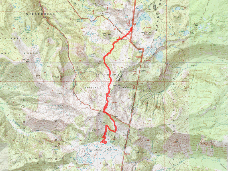
We started out down the REALLY bumpy 4220 road to Breitenbush. It is about 6 miles of gravel road ranging from pretty normal gravel to REALLY rough areas with big gulleys, rocks and potholes. When we got to the parking area at Breitenbush, we were surprised to only see a few cars. Since it was the end of the Labor Day weekend, we expected to see quite a few people. We headed down the trail, passing the side trail for Pyramid Butte which we did last year (a cool trail with GREAT views), and passing several hillside meadows which were blooming with wildflowers.

The wildflower season has to be pretty short there due to elevation – they take full advantage of their short season!
There was nothing significant on the trail until we started getting near the treeline, where the trail gets really rocky, and we started encountering snow fields.

The trail gets a little indistinct in places since it isn’t visible most of the year – some places we followed tracks across the snow fields, some places we just took our best guess. We made our way up the steep rocky hillside up to Park Ridge, where there is an iron post marking the top of the ridge. A little farther down the trail (down the ridge), there is a very old sign marking the entrance to the Willamette National Forest, and on the other side it announced the entrance into the Mt Hood National forest. The sign still says the Skyline Trail (not the PCT), showing how old it is. It is amazing the sign is still standing.


The view from Park Ridge are absolutely amazing – Mt Jefferson is right in your face, and you can see Jefferson Park below you.

Looking north, you can see all the peaks and hills clearly, and looking east, we could see (mostly) eastern Oregon. The only area that was obscured was the direction of the waterfalls2 fire, which was still burning. We occasionally saw flames from a couple areas of the fire, but they were in the middle of the containment area, so I’m assuming they are going to let that just burn itself out. It was interesting to look at the extent of the fire.

After eating some lunch on the ridge and resting a bit (it was a rather tough climb to the ridge), we started down the other side, into the magical world of Jefferson Park. On the way down the rocky trail, we passed many meadows of wildflowers. After a bit, we started passing through trees again-real trees, not the spindly, scrawny kind that were on the ridge. The trail improves a bit as it gets less rocky and continues its descent. We passed a really neat waterfall from an un-named creek that feeds Russell lake.

It took a 20′ drop or so – Kirk commented it would probably be a neat place to take a shower for a dirty PCT through hiker, although getting to the bottom of the waterfall would not have been easy. Continuing our trip down, we ended up at Russell Lake – it is a fair sized lake that has one side that is pretty shallow, but gets deeper in the middle. There were LOTS of little fish jumping. We stopped for a while to soak our feet in the lake and enjoy the view. Mt Jefferson rises from Jefferson Park steeply, and it was interesting to look at all the glaciers now that most of the snow has melted.


After the refreshing soak in the lake (and little to no bugs!), we started the long slog back up the hill to Park Ridge. For some reason, I had a really hard time making the ascent back up. Maybe I was tired, maybe I’m just out of shape, maybe it was the altitude. At any rate, I was huffing and puffing pretty good getting back up the hill. Once back up on the ridge, it was all downhill to the truck. We made really good time going downhill. We met one group (a family) that was headed up to camp at Russell Lake. On the way up, we met a lone PCT through hiker, and on the way back down, we met a couple who was through hiking and was anticipating completing it by Oct 1st. We didn’t find out where either group was from, though.
The trip back down was pretty uneventful, except for the encounters with the other hikers. After getting back in the truck, we made one more side trip on the way home. We stopped at the Breitenbush cascades, which is a tiered waterfall of the north fork (or the north fork of the north fork) of the Breitenbush river. I had heard about this previously, but never had enough time to stop and investigate. It was a great way to finish out a perfect day of hiking. The “cascades” are 20-30′ tiered waterfalls. We only went to the first two tiers, but you can get out on a flat rock on the second tier and get a great view of the falls. The trail was a little rough, but was easily passable to the first two tiers.


After the last little side trip, the long trip back to Estacada was capped off with a great meal at Fearless brewing.