
| Date | 8/8/2012 |
| Location / Trail | Old Skyline Trail |
| Weather | Sunny |
| Start / End | 3:15 PM – 5:30 PM |
| Distance / Elev | 2.5 miles (mostly in circles!) |
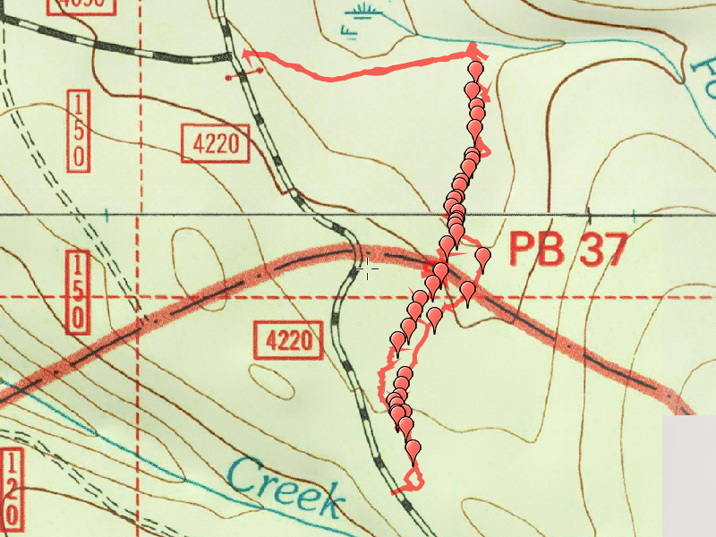
After getting a taste of locating old trails the prior weekend, (seeing the different Skyline Trail segments), I got so excited about the Skyline trail that I had to take a day off from work and go out mid week to do some more exploration. We did the Horseshoe Saddle, PCT and Gibson Lake trails in the morning and early afternoon (see separate trip report) and then headed back up to scout south from the old decommissioned road at the junction of 4690 and 4220. I’m assuming that road was the continuation of the 4690 road at some point – The old USGS map shows its continuation, but it doesn’t go too far.
We hiked up to the point where the old Skyline Trail crosses the road, and hiked south. We started looking for blazes and found a bunch. I marked waypoints right next to all the blazes we saw, top hopefully show the route of the trail more clearly. I also think there might have been two alignments of this trail – if you look at the map, there are two separate, parallel tracks at one point where there are blazes. But looking at the majority of the blazes, I think the route is pretty apparent. It is obvious more exploration needs to be done to nail down the exact route of the trail. There are some VERY messy areas in there – LOTS Of blowdown, but once you get up on the hill, the trail is VERY apparent.

We also found something REALLY interesting – an old Insulator! It was just off what appears to be the route of the trail, but very close to it.

We headed up the (by this point) very apparent tread up to a pretty level spot, which is really close to the 4220 road. We walked out to the road as you can see on the map. We were running out of time, so we didn’t continue, but we did find a good portion of this segment of he trail I think, and I’ve got a good track of it. Looking at the blaze waypoints on the map, it seems the route is very clear.
When I was processing the GPS track, I found one other interesting thing – In my Garmin map software, it has some old trails – it doesn’t list the name of the trail, but it does show a trail in this general area – it shows it hitting the 4220 road, then veering off again for a bit before it gets to Olallie Meadow. I’m thinking that may be a reference to the Skyline trail, because it was heading straight for 4220.
We didn’t have any flagging tape with us, but where we could we tried to tie the old flagging that was on the ground around a tree or at least get it off the ground so it was visible. Each subsequent visit should be easier to negotiate. Next time I go I will definitely take some flagging tape to make finding the route easier.
An absolutely amazing day in the forest, hiking the old route of a venerable trail. You could just feel the history…..Amazing!
I will be back to do more explorations of this trail for sure. I have already decided that once my goal of hiking all the trails in the district is complete (2 more hikes!), finding the route of this trail and bringing it back will be my next goal. I’m sure it will be an amazing journey….