
| Date | 1/25/2014 |
| Location / Trail | South Fork Water Pipeline |
| Weather | Sunny |
| Hiking Buddies | Kirk and Zack |
| Start / End | 10:15 AM – 3:40 PM |
| Distance / Elev | 3 miles |
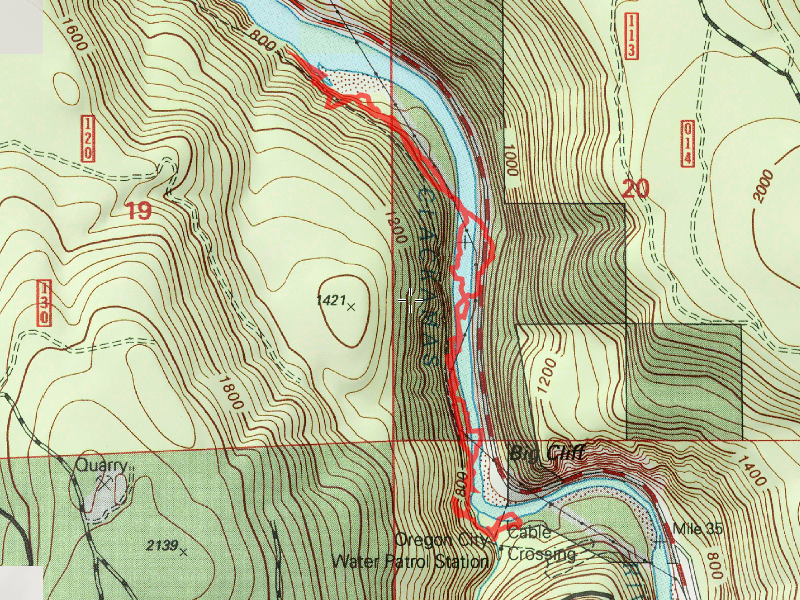
The day started at the location of the old “Oregon City Water Patrol Station” (that is how it is labeled on the maps). The house is no longer there, however there is a nice big pullout and lots of parking there. Kirk brought his canoe and the plan was to canoe across the river over to the landing on the other side and then follow the pipeline trail north as far as we could.
The trip across the river went easier than expected – the current in the middle of the river was relatively fast, but it was pretty narrow – on the far side of the river was an eddy that was actually moving upstream! Anyway, we quickly made it across the river, got the canoe out of the water and then proceeded to find the pipeline grade. Doing this trip in the winter is really the best option for two reasons: 1 – there is LOTS of woody brush (salmonberry, blackberry, various grasses) that would be tough to navigate in the summer. 2 – There is a fair amount of poison oak along the pipeline grade – in the winter it is dormant, so it a lot easier to move past without getting itchy.
We wandered around a bit, and finally found the pipeline grade and started our trip north. I had forgotten how rough this “trail” was – and I think it has gotten worse since I was here last. We struggled with the downed trees and brush and it seemed the farther north we went, the worse it got. I finally had enough of it, and pulled out my little pruning saw and started cutting some branches. Zack had just given me new loppers, but I didn’t bring them, thinking I would not need them – that was a mistake. The pruning saw helped a lot, but loppers would have made it easier. Kirk soon took over the pruning saw, and I got out my hand pruners. There is a LOT more clearing that needs to be done on that trail, but we made a bit of an improvement. Here is some of what we had to go around (and there was a lot worse that I didn’t take photos of:

Here is Zack and Kirk clearing a particularly rough spot:

Once we got past the “cliffy” parts of it, just north of the bend where we started, the going improved a bit, but it was still rather brushy:

Although you couldn’t see the pipeline itself most of the way, these coax cables were visible almost the entire route – they made it pretty easy to follow the route of the pipeline:

Sometimes they were buried in the duff, sometimes they were stretched in mid air (like guard rails almost) – this photo also shows a big downed log that was cut at some point long ago – it wasn’t cut all the way through, but a notch was made in it – it was cut so long ago the notch was now at ground level:

A little farther up the trail, we found this item – Kirk thought it was a device to bleed off air from the pipeline, which kind of makes sense since it seemed to be at a high point along the pipe:

We continued north, following the river – the route improved a bit, and we even got to some rock slide areas where the grade was very good (if you look closely, you can see the coax cables in the lower left of the image):

Around one of these rock slides, an interesting/scary thing happened: When Kirk moved a log off the trail and threw it downhill, the rocks started giving way – a mini slide occurred. We were waiting for it to take out the trail, but it didn’t (thankfully). It did slide a LOT of rock downhill however.
Continuing north along the grade, we finally found the tunnels we had heard about. The tunnels did not start at the cliff face directly north of the bend in the river, they started a lot farther north. Here is the entrance to the first of four tunnels:

They were not very large – and seemed to get smaller the farther north we got. The first one was big enough to stand up in, but just barely

This was a very weird sight inside the first 3 tunnels. Groups of daddy long legs spiders and crickets, all grouped together. We had no idea what was going on there, but it was really weird looking:

At the entrance to the second tunnel, Kirk found an old insulator laying on the floor of the tunnel – it was kind of a weird place to find one:

All of the tunnels were in the cliff behind an “island” in the river. I’m not sure it is actually an island, but it does have a slough going alongside the cliff on the north side, and looks kind of like an island. This is the view from between two of the tunnels looking out at the flat area between the cliffs and the river:

Inside the 3rd tunnel, we had to walk on top of the pipe – there was up to a foot of water in the tunnel and it made for difficult going:

When we got to the other end, we found out why – a landslide had blocked up part of the tunnel exit and there was water dripping down into the tunnel from runoff. I”m sure during wetter parts of the year, this tunnel has a lot more water in it. Here is the exit of the tunnel – that straight thing is not a piece of the pipeline, but a tree that had fallen downhill – you can’t even see the pipeline, just the small tunnel exit:

The last tunnel had what looked like a piece of petrified wood in the ceiling of it:

And it also has a curve in it:

At the end of the 4th tunnel, the pipe takes a hard turn and goes straight down to the water – it is kind of hard to see in this photo because the pipe is covered in moss and ferns, but it goes downhill at probably a 60-70 degree angle until right above the water and then turns north right above the waterline:

On the way back someone noticed this interesting “glaze” on the wall of one of the tunnels:

It reminded me of stuff I remember seeing in the Oregon Caves. When looking it up, they referred to this as calcite deposits. It looks like it is soft, but it feels just like rock (although smooth).
After exiting the 4th tunnel, and realizing we were pretty much at the end of our route, since the pipeline went down to the water and seemed to head at waterline for a while, we decided to head up to the top of the hill and see what we could see – we got up there and saw a very difficult bushwhack. We decided this would be our turnaround point, so we stopped for lunch.
Heading back was pretty uneventful, and considerably faster than the trip in, since we had done all that clearing on the way in. We enjoyed some of the many cliffs on the way back:

We made good time back, and since we were a little early, we decided to go explore a little ways up the “Gipper” trail – it heads up and over the hill over to Hillockburn. I have been on that trail a couple of times and it offers some really nice views (this picture was taken on a trip in 2012):

After exploring up the Gipper trail a bit, we headed back down, back to the canoe, and made our way back across the river without incident. Kirk had to go home to a family dinner, but Zack and I headed to Fearless for a beer and some sweet potato fries. On our way back, we stopped to look at the point we got to, in order to see where the pipeline went. While we were looking we saw an AWESOME sight – A Bald Eagle flew up from the river into a tree! As we made our way down river, the eagle followed us for a bit. They are absolutely beautiful creatures, and it was amazing to see in the wild. An amazing way to spend an incredible winter day in the Clackamas. It felt more like a fall day!