
| Date | 9/26/2015 |
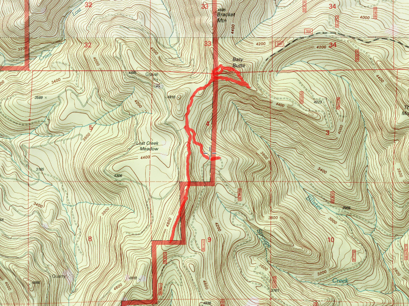
| Location / Trail | Baty Butte Trail - 545 |
| Weather | Foggy in the morning, Partly Sunny later |
| Hiking Buddies | Bodie (my dog) |
| Start / End | 10:55 AM – 3:00 PM |
| Distance / Elev | 5.7 miles |
We headed out a little later than normal – it was kind of foggy and looked like rain – but that was supposed to clear up and be partly sunny in the afternoon.
It has been several years since I’ve been here, and on the way up the 7010 road, it was obvious that thinning has been going on for a while. The forest looked really good where they had thinned. The road up to the point where the thinning stops was in great shape (obviously because of the thinning projects). Beyond that, the road deteriorated a bit – got narrower and a little rougher, but wasn’t bad.
We were driving thru the clouds on the way up to the trailhead – I was hoping that the clouds would burn off so we could have some views later in the day. We passed the Culvert replacement on 7010 at Blister/Stroupe creek that stopped us the last time I was here in 2011. That project is long complete now. We finally hit the 7010-160 spur road that takes you up to the trailhead. One the way up, we ran into a BUNCH of new, DEEP waterbars in the road:

You have to take these VERY slowly as some of them are VERY deep. I’m not sure a passenger car could navigate some of these.
We arrived at the trailhead and headed down the trail. Very quickly, we found some VERY recent trail maintenance!

A big thank you to whoever did this work. Both logging and brushing were done VERY recently.
As we proceeded down the trail, we came to the first rockslide and found brilliant fluorescent fall colors – this photo doesn’t even begin to do it justice – the colors were so vibrant – it was amazing!

We came to the junction and headed north/east – the goal was to get to the top of Baty Butte and have lunch there. On the way, I met a bow hunter (he was VERY quiet-didn’t even know he was there until we were right on top of him) and later we met another couple – the husband had a bow but said he really wasn’t hunting.
As we progressed east, we went under the “white spot” of Baty Butte, and it looked like the east ridge might be a viable way to get up to the top. At an opportune place, we started up the east ridge – we found what appeared to be old tread heading up, but shortly got cliffed out (it got VERY steep and narrow – didn’t want Bodie to trip and fall), so decided to come back down. On the way down, we found what appears to be an old water bar in the tread:

Definitely didn’t look natural – I’m very sure this was some sort of trail at one time. We headed back down the trail to the west side ridge – to a switchback with an obviously homemade sign that said “Bracket Mountain” and pointed north. Figured maybe there was some sort of user trail, so we headed that way. The “tread” didn’t last long, so we ended up basically just walking more or less east – essentially straight uphill – near the top of the hill we found old tread and figured this must go to the top. Well, after going back and forth on the tread, and finding the spot on the east side where we had been earlier, it was obvious that there was no recognizable (at least I didn’t see it) tread to the top – we were VERY close, so we just headed uphill a bit and finally made it to the top of Baty Butte. It was a little bit of a letdown – since it was an old lookout location, I was hoping to find some remnants of the lookout – at least something. We found nothing – it is a very small area with steep dropoffs on all sides, so we had to be careful. Some nice views, however:
Looking west to the Molalla drainage:

Looking south/southwest back to where we started:

Looking south:

Looking north:

And there was a geocache at the very top:

We ate lunch and headed back down the west ridge – we followed the trail down – it wasn’t much of a trail, heading pretty much straight down the hill (it was REALLY steep). On the way down the hill, I literally tripped over this piece of old phone line:

We finally found the real trail again and headed southwest down the trail. When we got to the southern part of the trail, it was obvious it hadn’t had much activity. It was VERY brushy in places and had quite a bit of blowdown. We ended up hiking about a mile south of the junction, and in that mile, we counted about 40 trees down – and some spots in the trail are almost completely grown over with brush. This portion of the trail needs a bit of love.
Just south of the junction, there was this neat view of Baty Butte and Mt Hood (which had emerged from the clouds finally):

And a little farther, one of the cool side hill meadows (the first one as you head south):

And the neat ridge walking in the trees – this is just really cool to me:

We walked down the trail for about a mile and I could tell Bodie was getting tired. We were nearing our turnaround time anyway, so I decided to turn around and come back. I think it was just about the perfect length for Bodie. Had we not expended so much time and energy trying to climb to the top of Baty Butte, we could have gone farther south, but I was glad I finally got to see the top of the Butte.
A very nice and pleasant day in the woods.