
| Date | 7/23-7/25/2017 |
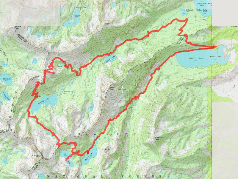
| Location / Trail | Pettit Lake - Sawtooth Wilderness |
| Weather | Mixed - Hot to cool with a little mist |
| Hiking Buddies | Kirk, Sarah and Carly |
| Distance / Elev | 23.5 miles |
Sarah picked out the location this year, which was somewhat close to where Carly is working for the summer – the Grand Tetons. The plan was somewhat loose, since we weren’t really sure exactly what we would encounter. This was the rough plan for the backpack trip:
- Day 1 – Pettit Lake to Farley, Edith or Imogene Lake (depending on how the day went)
- Day 2 – Hike to Alice Lake (needed a relatively short day since we were traveling to the Grand Tetons after we were done)
- Day 3 – Alice Lake out to Pettit Lake and then drive to the Campground where Carly was working
We left home about 7am on Saturday and headed to the Pettit Lake trailhead in Idaho. We were not sure if we would be able to find a campsite at the campground there, but if not, we figured we could do some dispersed camping nearby. The plan was for Carly to meet us there – she worked until 3pm so she was going to be there late. Since there was no cell service at the campground, it was a bit iffy on whether we had all our communication correct. We got to the campground early evening and found it full, so we looked for a good dispersed spot. We found a pretty good spot near the creek and called it good. This was our campsite the first night – I climbed up a small hill to get a better look at things and see if I could get a cell signal to text Carly – but had no luck.

I waited on the road in to the campground (so she would see me), and fortunately, Carly showed up a little after 9pm. I was somewhat relieved that we had successfully met up and we could now begin our 2017 trip.
We went to bed in our camp, had a VERY cold night, kind of slept in a bit due to the cold night, then woke up to frosty tents! We were surprised since it was so hot the day before. Fortunately, it warmed up pretty quickly, so we cooked breakfast, packed up and then drove to the trailhead. Shortly, we were on our way! This was where we started our adventure:

We headed down the trail, shortly taking the uphill junction to the trail that would eventually take us to Farley Lake (I couldn’t find trail names or numbers). After the junction with the trail coming in from Yellow Belly Lake (what a name!), we crossed a small creek. I was the only one who got their feet wet – I didn’t like the log crossing – but the cool water felt good on my feet. While I was putting my boots back on, a packtrain came along and crossed the creek – I think Kirk counted 12 horses:

After letting the packtrain go past us, and me getting my boots back on, we continued up the trail. Soon, we got our first real glimpse of the mountains and a flower filled meadow:

We continued up the trail – it was pretty hot by this time and the trail is pretty exposed – we were all getting really hot and trying to stay as hydrated as we could.
As we got closer to Edith Lake, the trail crossed the creek 3 times on the way up the hill – this was one crossing point:

After the third crossing we finally arrived at Edith Lake:

When we got there we encountered a rather large group – we found out later it was a group of “Father/Child” campers – they had been doing a “Father/Child” backpack trip annually for the last 5 years or so. It was interesting that we were both doing the same thing, although their children were much younger. We set up camp up on the hill above Edith Lake. The mosquitoes weren’t too bad here. Carly, Sarah and I kind of cleaned up at the lake, while Kirk went for a brief swim (the water was really COLD).
We made dinner and then pretty much just went to bed. We were all pretty tired due to the heat. I got up early the next morning and captured the sunrise from our camp on Monday morning:

And here is Edith Lake from our campsite in the morning light – we would be headed up to the pass in the upper middle of the photo. It is hard to see the ridge.

We made breakfast, cleaned and packed up and headed out (and up). We climbed above Edith Lake and started climbing up to the pass – we passed thru this beautiful meadow:

And as the trees thinned out, we saw many of these old, fire damaged trees – I thought they were really neat looking:

As we continued up, we got into more snow, having to find the trail across large snowbanks. Most of the time it was pretty easy since there was already footprints leading the way. Here we are looking back down the valley we came up the day before – Farley and Yellow Belly Lakes below (Edith Lake is not visible):

When we got up to the pass, we climbed up a side ridge/peak (un-named – 9568)to get a good view of the area. The climb wasn’t bad at all – we dropped our packs at the pass and headed up the ridge. The view was pretty spectacular. From on top of the ridge, you could see all 3 lakes – Yellow Belly, Farley and Edith below:

And Toxaway Lake on the other side – we would be shortly heading down to it:

While exploring the peak, Carly heard some noise and saw two deer up on the peak!!! She spooked them and they ran down – but we were all surprised they were up that high. No one got any photos of them, and she was the only one who saw them unfortunately. After enjoying the views for a bit on the peak, we started down – the wind was picking up and we started to get a little light mist. We were concerned it was going to really start raining. Fortunately, that was about all we got – a few very light drops of rain and light mist.
We continued down the long slow, descent to Toxaway Lake (the trails were really well graded), and we walked thru a variety of beautiful wildflower meadows:

When we got down to the trail junction at Toxaway, we saw a couple of guys having a break near the campsite area. We stopped for a few minutes and then continued down around the Southeast corner of the lake and ran into the bottom of an avalanche that occurred last winter:

On top of the avalanche area we got a good view up the hill to where we could be going later. It was a really neat smooth rock hillside where the snowmelt was coming down. We ended up having lunch here and resting a bit. There was another family with small children (you can see them near the water in the above photo) that was ahead of us who we would see off and on up the trail for a bit.

After lunch, we continued up the hill and ran into more avalanche damage up the hill. This damage completely obliterated the trail for a bit and was difficult to figure out where to go:

We successfully navigated the avalanche damage and shortly got to the first of 3 small un-named lakes before the pass:

We continued up (and up and up) – this is almost to the pass – looking back from where we came:

And we finally get to the pass with its 20′ wall of snow – I should have taken a photo of the other side of it. It was pretty impressive (the trail heads off on the left side, hugging the cliff to begin):

Once we were over the pass, you get a good view of the Twin and Alice Lakes below:

We headed down the trail, encountering a few snow fields and quite a few people (including families with small children) coming up. It didn’t take too long for us to reach the shoreline at Twin Lakes:

We went out on the land spit between the two lakes and explored a bit, enjoying the beautiful location – nestled between the mountains. After exploring around the Twin Lakes a bit, we continued on our journey down to Alice lake. On the way, there was this “right turn” waterfall which was really cool:

And finally, we came to our objective for the day – Alice Lake with El Capitan towering over it:

We started looking for a good campsite, and finally found one, although the mosquitoes were TERRIBLE – you could HEAR them buzzing in the swarms. They were close to the worst I’ve experienced (I think Serene Lake and Cache Meadow many years ago was worse):

After we got camp setup, we explored a bit more – here is a cool island in Alice Lake:

As usual, we made dinner, cleaned up and pretty much went to bed – partly due to being tired, but partly due to the mosquitoes. We planned to try and get an early start so we could get on the road to the Grand Tetons (it is at least a 6 hour drive – over 300 miles). We got up the next morning and quickly made breakfast and broke camp. I think we were on the trail by a little after 8. On our way out, we got this great view of Alice lake with El Capitan looming over it:

And then the rest of the mountains surrounding the southeast side of Alice Lake:

Once we got past Alice Lake and its little lakes below it, we saw our final objective for this trip – headed down the valley and back to Pettit Lake:

On the way down the hill, we ran into more avalanche damaged areas and had to find our way around the area where the trail was obliterated. At one point, we got slightly separated and I ended up crossing a creek, only to have to come back over when I heard Kirk yelling at me from up on the rockslide-luckily I heard him over the roar of the creek!. I had gone down to explore what looked like a possible trail (I think it was an old alignment of the trail that was no longer used). We ended up going up into a rockfield and around all the damage and eventually re-joined the trail.
After that experience, shortly after we re-joined the trail, we stopped at a rockslide that was next to the creek. We saw a Pika there (this isn’t a great photo since he was hard to see, but he was pretty cute):

And continued down the hill towards Pettit Lake. I think we counted like 5 creek crossings on the way down. Most were pretty easy, but the last one was rather difficult. There was a family there trying to get across. Carly ended up crossing on a sketchy log, I ended up putting my crocs on and getting wet – Kirk and Sarah crossed on a pair of logs a bit upstream (which was really the best option). After making that last crossing we were almost to the last mile hike to the trailhead:

We finally got there (it seemed like a REALLY long mile). We did a little cleaning up in the bathroom in preparation for our trip to the Grand Tetons, and then headed out – I think it was about 11:30 when we left the trailhead. On to phase 3 of the trip!
On the drive to the Grand Tetons, we went thru the Craters of the Moon park – I snapped this quick photo from the car – we didn’t stop since we had a long ways to go, but it was pretty interesting. Someday it would be nice to stop and investigate it.

We had lunch in Hailey, Idaho at the “Power House” (great burgers and an interesting place – a combination pub/restaurant/bike shop), and then drove to the Signal Mountain Campground in the Grand Tetons where Carly is working this summer. Fortunately, we had a campsite waiting for us. We setup camp and then started our next phase of this trip.
This backpacking trip was tough, but very interesting, and areas that I’d not seen before. It was great to spend several days with Carly. We had a great time and saw some beautiful scenery. I can’t wait for whatever trip we plan for next year.