
| Date | 7/18-7/21/2018 |
| Location / Trail | Redwoods |
| Weather | Sunny |
| Hiking Buddies | Kirk and Sarah |
| Distance / Elev | 31.5 miles |
Unlike prior trips, we had kind of a loose itinerary. We had a difficult time finding accurate/current information and maps of the area, so we decided to have a rough plan and then adjust as we went along based on info we got at the ranger station(s). This turned out to be a good call. We found out that the whole Redwood park system is kind of a hybrid – being managed by state and federal (national parks and forest service). It made our trip to the ranger station rather interesting since he had to make a couple of phone calls to verify things for our various stops.
The rough plan was this:
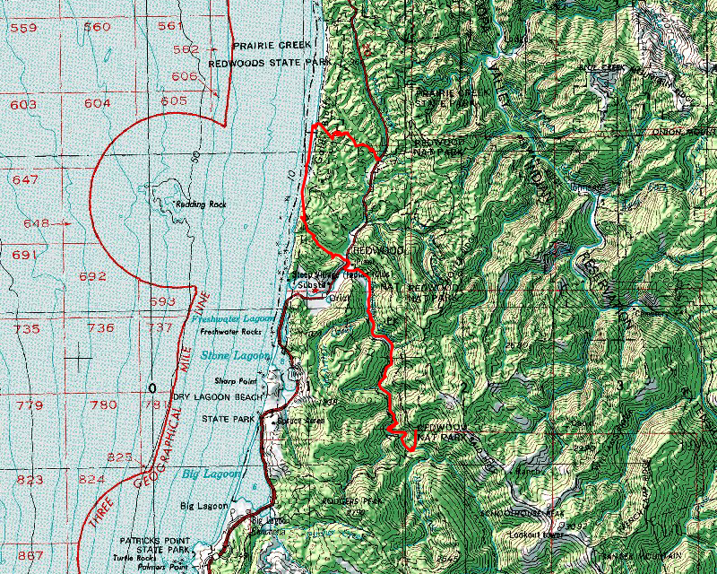
- Wednesday – Drive to the Ranger station to get permits and then stage vehicles for the shuttle hike – hike down Dolason Prairie trail to Redwood Creek and camp on the gravel bar (dispersed camping)
- Thursday – Hike up Redwood creek to Tall Trees Grove – do the Tall Trees loop and then hike as far as we could up the creek and camp again on the gravel bar
- Friday – Hike up Redwood creek to the trailhead – then do some road walking over to the Skunk Cabbage Creek section of the Coastal trail and hike up the beach to the Gold Bluffs campground
- Saturday – Hike back to the Elk Prairie visitor center to get one of the cars – pick up second car and then visit Lyons Ranch, and some other highlights before starting the trip back home. Find someplace to do dispersed camping that is on the way home
- Sunday – drive the rest of the way home
Our actual plan was pretty close, however we didn’t head down the Dolason Prairie trail – we went down the Tall Trees trail (saving us about 3-4 miles of downhill hiking). Other than that, things went pretty much according to the rough plan. Our hiking mileage looked like this:
- Wednesday – 2 miles
- Thursday – 10 miles
- Friday – 11.5 miles
- Saturday – 5 miles backpacking plus 3 miles of day hiking
- Total Mileage: – 31.5 miles
Day 1 – Home to Redwood Creek
We headed out from Oregon City early on Wednesday morning (6:00am) – we had a long drive – google said it would take about 7 hours to get to the visitors center and that was with no stops at all – we figured it would take us at least 8 hours, which turned out to be just about right. We had to get the permits, stage the cars for the shuttle hike, and then hike down to the creek and find a good campsite. We weren’t sure how long all that would take and make sure we had enough time to find a campsite before dark. Fortunately, we planned well, and the elimination of a few miles of hiking helped a bit as well. When we got to the ranger station, he advised us to park at the Tall Trees trailhead instead of Dolason Prairie – it was safer. We got all the permits, staged the cars, went to a different ranger station to get bear canisters and then headed down the Tall Trees trail and almost immediately came to the junction with the Emerald Ridge trail – since we removed a few miles at the start, we figured we could add a little more mileage and see more of Redwood Creek. We took the junction and headed south down to Redwood Creek. Very quickly we got our first glimpse of what was to come over the next few days – Big Redwoods!:

It didn’t take us very long and we were at the creek – at that point the goal was to find a campsite along the gravel bar. In this section, we could camp anywhere along the gravel bar (which was very wide this time of year). When we got to the creek, we waded over to the other side to investigate potential sites. We would be wading the creek many more times over the next two days:

We pretty quickly found a really nice campsite a little south of where we arrived at the creek – nice and sandy with a fire ring and a nice sitting bench:

We were tired from a long day of driving and hiking, so we went to bed early.
Day 2 – Redwood Creek to Redwood Creek (farther north)
We got up early on Thursday, packed up and headed north up Redwood creek. We crossed Redwood creek and found this beautiful deep pool:

As we headed north, we got near the Tall Trees Grove (which was a highlight of the day) – it was at the end of this straight section of creek:

We crossed the creek again, and then popped right into the Tall Trees Grove. Here was the first tree we saw in the tall trees grove which was pretty impressive:

There was a bench in the middle of a bunch of large trees where we changed back into our boots (we had been wearing wading shoes since we had been going back and forth across the creek). We then took the short loop around the tall trees grove. This is one example of the scale of what we saw – and I’m sure this was not the largest tree we saw:

The scale of these trees is just incredible. I saw hundreds of trees over the course of our trip, and they never stopped inspiring a sense of awe.
Another very interesting thing was seeing how tough these trees are. They have a real will to survive. Fire is a part of their existence (the interpretive signs said fire was naturally occurring every 250-500 years). We saw many trees like this – severely burned out from the inside, but somehow still alive and apparently thriving:

We learned that when redwoods are stressed, they release “children” – shoots with the same genetic material – in some spots where trees had been logged, you saw an entire ring of trees around the logged stump – sometimes it is called a “fairy ring” or “family circle”. It just shows how persistent and tough these trees are. They said some trees are over 2000 years old!
Since the Redwoods were the highlight of the trip, here are some more photos for scale:


And this photo is pretty cool I thought – looking straight up from a cluster of trees:

And here is a 360 photo from the Tall Trees grove
After doing the Tall Trees loop, we continued north up Redwood creek, crossing the first seasonal bridge over to the west side of the creek:

From there we continued up to an old road (which was hardly recognizable as a road in most places). We headed north on this old road, a bit above the creek. We got to the Bond creek crossing and found the “bridge” was gone. Most of the bridges were in pretty rough shape. Some with missing handrails, most with missing or partially missing boards:

As we headed north on this trail, there were some pretty large trees here too:

The other unexpected thing was that while we were there for the redwoods, we also saw the largest maple tree I’ve ever seen – it was absolutely huge:

A little bit further down the trail we encountered this cut log that said it was 750 years old and we easily saw trees twice that size still alive:

We had to camp before the last seasonal bridge at McArthur Creek, so we spent a while looking for candidate campsites. We knew the next day was going to be rather long, so we wanted to get as far north as possible to reduce our mileage on Friday. We preferred a shady spot in a sandy area rather than camping on the gravel itself (that would be kind of hard). We dropped our packs and looked around – we crossed the creek and headed north – all the way to McArthur creek. We found what we thought was a pretty good spot a little south of the creek:

And looking upstream from our campsite:

We were tired again and went to bed early (after struggling to get out our messages from our SPOT and Garmin units – apparently even though it had a clear shot of the southern sky, we had to go all the way over to the east side of the creek to get the messages to send).
Day 3 – Redwood Creek to Gold Bluffs
We got up Friday morning and continued north along the old road, shortly getting to the second seasonal bridge on Redwood creek:

After crossing the bridge, the trail became much more “manicured” – I’m guessing that is because in the winter that bridge crossing point is the farthest you can go down the trail without wading the creek (which would probably be pretty tough, since it flows pretty high in the winter):

We soon got to the Redwood Creek trailhead with picnic tables and a bathroom. We took advantage of both, spending a little while there snacking. We then headed up the road – this was the short road walking section we weren’t too thrilled about. But as we were heading up the short trailhead road, Sarah noticed a bear on the side of the road! He was quite a ways away (150-200 feet), and rather small – he took off for the trees as soon as he saw us. He was so fast I was not able to get a photo.
We made it up to highway 101, which had a fair amount of traffic on it – this was the section we were most dreading. We started off facing traffic (as you are supposed to do when walking on a road), however there wasn’t much of a berm to walk on and there was a semi-blind corner. Kirk went across the road where there was a guardrail, and there was a nice concrete path along the outside of the guard rail – much safer than where we were walking so we headed back across the road and hiked behind the guardrail until we got to the road to the Skunk Cabbage Creek trailhead. We headed up that road – no traffic at all. We got to the trailhead and there were no cars there either, which surprised us.
We headed down the trail and soon we were into the lush coastal trail forest with more spruce and fewer redwoods:

And saw some huge skunk cabbage (which gives the creek/trail segment its name):

We continued to the “overlook”, which was rather disappointing since it was rather brushed in. We stopped there for lunch and then headed down to the beach. There were several areas in this section where we were walking in a literal tunnel of vegetation – and some spots were rather dark:

And this shows how lush the understory is – a carpet of sword ferns 5-6′ high in places:

We finally got down to the beach and rested a bit. This is where I made a mistake – I should have left my boots on, but I took off my boots and walked barefoot for a while – later I put on my crocs to try and protect my feet (I had a few hot spots and minor blisters that were getting abraded by the sand). Wearing crocs in the sand isn’t a good idea – it gets trapped in the croc and rubs on your skin anyway. This section of trail along with the sand made kind of a mess of my feet – a bad decision I would pay for the rest of the trip.
This is a shot looking up the beach from where we came down. We would be heading up this way – about 3 miles up the beach to the campground:

After a bit, we got to the beginning of the Gold Bluffs, which were not named for their color, but named for the gold they contained. Early in the late 1800’s/early 1900’s these cliffs were mined for gold using a variety of techniques. It sounded like the location of our campground might have been a mining camp too. Here is a photo of the beginning of the Gold Bluffs:

As we were walking up the beach, we found this almost perfectly intact jellyfish that had washed up on the beach – it was quite interesting:

After what seemed like forever (walking in the sand with a backpack is harder than it sounds), we finally arrived at the campground. We saw not a soul on the trail nor on the beach until we were almost to the campground. The campground was pretty full of car campers, but we had a reservation in the “Hiker/Biker” section. This was our campsite for Friday night – a nice place with picnic tables and fire rings:

They also had water along with real flush toilets and showers. I hadn’t brought soap, but I used some of the hand soap from the bathroom to take some sort of a shower – I felt a lot better after I washed some of the trail funk off me.
While we were at the camp, I was enthralled watching some sort of large bird (vulture?) circle around the cliffs. I took a short video of him/her:
And while I didn’t stay up for the “real” sunset, I did take this photo of the sun setting on Friday night:

I went to bed early, while Kirk stayed up for a while and explored the area a bit.
Day 4 – Gold Bluffs to Elk Prairie, then dispersed camping
We all got up early on Saturday and got ready to head out. Overnight, another pair of hikers had arrived in camp. We talked with them for a bit – We found out They were from Washington and Colorado and had been making rounds around the west to different national parks. They had apparently come in the Miner’s Ridge Trail (the one we were taking to head out) the night before and were surprised at all the cars in the campground – they thought it was a backcountry campground only.
We headed down the road – down the “Tsunami evacuation route” to the Miner’s Ridge trailhead. It starts as a gated road – we were thinking the road was so that people could drive up to safety from a Tsunami. The road ended at a bridge over Squashan creek. On the way up the road, we met a state ranger who was testing the water source for the campground. They pipe water from the creek into a couple of large tanks which feed the campground – but someone comes up every day to test the water to make sure it is safe. We had a nice conversation with him and then headed up the trail:

Of all the trails we were on during this trip, I think this was my favorite one – it had quite a variety of ecosystems and had a lot of Redwood trees on it:


We continued down the trail, encountering no one until we were about 2 miles from the Elk Prairie visitor center. We continued down the trail, encountering more and more people the closer we got to the visitor center. Near the visitor center we encountered a large group of elderly people who were from all over the US. They were taking a short loop trip near the visitor center. We quickly made it to the visitor center and then back to our car. At that point, we needed to return the bear canisters we had “rented”, so we needed to go get the other car since we had left the “covers” for the canisters in that car. It was a bit out of our way, but we made the trip and returned the canisters without incident. While there, we asked about the condition of the Bald Hills Road all the way down to Martins Ferry and Weitchpec – the ranger said it was passable but thought it was a scary road – we just needed to go slow. We decided to try it – we have lots of experience driving narrow, windy gravel roads. It turned out fine. I’m not sure what she thought was so bad about the road – we’ve driven roads that are a LOT worse than that one was.
Anyway, on the way down, we decided to take a look at a couple of other items. Due to my feet, I wasn’t up to explore the old Lyons Ranch (which would have been about a 5 mile hike) – I don’t think we had time enough for that either. But we decided we could go see the Dolason Barn – part of the Dolason Prairie trail that we didn’t end up taking. Plus we got to look at the lookout on Schoolhouse Peak.
Here are some photos of the Dolason Barn – the Dolason family raised sheep on this property for several generations:


And this is a photo of some of the hillside Dolason Prairie:

Although the signs said the barn was only .75 miles from the trailhead, it was more like 1.25 miles – not terrible, but we were kind of in a hurry, wanting to find a campsite for the night before it got dark. There was only one car at this trailhead and we encountered the person partway down the hill. When we got back to the car, ours were the only cars left in the lot. Not a very highly used trail for sure. It is tough in that you go downhill on the way in, having to make up all the elevation on the way out. Maybe that is why it doesn’t seem too popular. It was interesting to see the barn and the prairies though.
Once back at the car, we continued down the road to the Schoolhouse lookout. We weren’t sure what to expect, but found a gated, locked road which led up to an active lookout. We walked up the road and when we got to the lookout the guy manning the lookout popped out on the catwalk and asked if we wanted to come up – of course we said yes! He came down and then led us up the stairs up to the lookout. It was apparently built in the 40’s and then partially burned at some point and then rebuilt/renovated. It appeared to be mostly steel, but looked a lot more modern that the lookouts I’ve seen. It had a big propane tank, a big water tank for fire fighting, and a non potable water tank for washing dishes, showers and the toilet (it must have had a complete septic system too). It was pretty neat to see. The cupola looked a lot like what I’ve seen in many photos – one side had the “kitchen” with a sink, refrigerator and stove and then the other side with a bed. And of course the Osborne Fire Finder in the middle:

We spent a few minutes talking with him (I wish we had gotten his name) – it was great. Unfortunately, we didn’t get to see much of a view due to all the smoke from nearby fires. But getting to see the inside of a real lookout was pretty special. Here is what it looked like from the outside:

We Left the lookout and then continued down Bald Hills road, which was very windy and did go on for a while, but it really wasn’t that bad. At some point it turned back to pavement and was pretty good all the way down to Martins Ferry. We were expecting to find some place to eat dinner before we found our campsite for the night – we found one place – the “Burger Barn”, but when we got there, it had either closed for the day, or was not open at all – we couldn’t tell. We didn’t really see ANY other place to eat, so we stopped at the local gas station/convenience store and got some sort of dinner – it wasn’t great, but it wasn’t terrible.
We headed north on highway 96, which took us into the Six Rivers national forest. We found what appeared to be an old abandoned campground, although all the signage was still in place – it was a little odd, but since we just wanted a place to sleep for the night, it worked out fine. We camped at the Aikens Creek Campground – which does appear on the FS Website, but there are no services (no water, no bathrooms) – that was OK with us. I ended up sleeping in the car – hoping the car seat would be a little better on my back than my pad had been – it was slightly better, but not a lot better.
Day 5 – Dispersed camping (Aikens Creek Campground) to Home
We woke up early on Sunday and then headed out. The plan was to find a restaurant for breakfast as close as possible. We were really out on the fringe, for we saw no restaurant at all until we got to Ashland, which was almost 150 miles away. So, we ended up eating a very late breakfast. We stopped at the Waffle Barn in Ashland – had a great breakfast and then got back on the road.
There was a lot of smoke all over the place, but it seemed like Medford was maybe the worst – it looked like smog it was so thick:

We stopped in Roseburg for gas and then headed the rest of the way home. We ran into some pretty bad traffic in Albany and ended up getting off I-5 at Brooks – it sounded like there were multiple accidents on I-5 – we had already been delayed at least a half hour and we all wanted to get home.
This trip wasn’t quite as flashy or spectacular as some trips we’ve done, but the huge Redwoods continue to amaze me – I never tire of looking at them. It was great to sleep among the Redwoods and to see a lot of the variety of the northern California back country.