
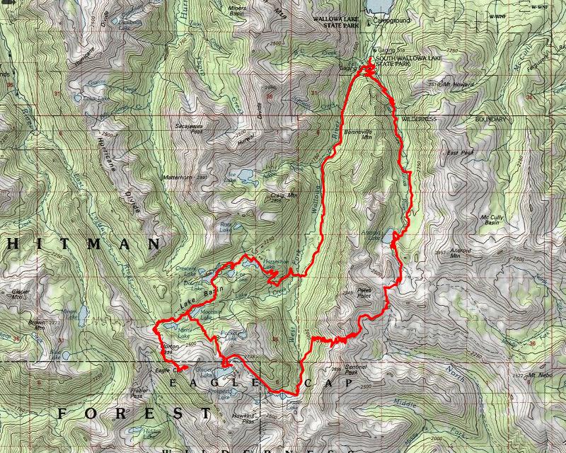
| Date | 9/16-9/19/2018 |
| Location / Trail | Eagle Cap Wilderness |
| Weather | Sunny but cold at night |
| Hiking Buddies | Carly |
| Distance / Elev | 44 miles |
We were very fortunate with the weather on this trip – it was beautiful fall weather. Sunny and warm (but not too warm) during the day, and below freezing at night. We had an ambitious plan:
- Day 1 – Drive to the Wallowa Lake trailhead and hike to Aneroid Lake – about 8 miles
- Day 2 – Aneroid Lake to Glacier Lake – about 11 miles
- Day 3 – Glacier Lake to Moccasin Lake – drop our packs and do a side trip up to Eagle Cap, then return and pick up our packs and go to Horseshoe lake – about 11 miles
- Day 4 – Horseshoe Lake to Wallowa Lake trailhead and then drive home – about 8 miles
We stayed to the plan, however we found out the mileages we had planned were a little low. Day 1 was almost a mile short, day 2 was about 2.5 miles short, day 3 was about a mile short and day 4 was about a mile short. Even with the underestimated mileage, it was still a great trip. On to the trip report.
Day 1 – Wallowa Lake to Aneroid Lake – 8.5 miles
We both left our houses around 6am – the goal was to meet for lunch in Enterprise and then head out to the trail shortly after noon. It all worked out really well. Even though she woke up late, Carly actually caught up to me a few miles outside of Enterprise. We ate lunch at Terminal Gravity brewing and then headed to the Wallowa lake trailhead. There wasn’t a lot of parking there, so we had to park quite a ways from the trailhead. We got all our gear together and headed up the trail. We took the 1804 – East Fork Wallowa River trail – it heads south and gains elevation almost its whole way. Shortly after we left the trailhead, we got a really nice view of Wallowa Lake:

A little farther down the trail, the map showed a “Royal Purple Mine” and a side trail which sounded interesting, so we headed up the side trail and saw this pipeline:

I found out later this pipeline is the supply to an electric generator down near the Trailhead. I’m assuming it must supply the Wallowa lake area – maybe even Joseph. It is operated by Pacific Power.
There was also a road there that headed uphill, so we followed it, thinking it would take us to the mine. Instead, it took us to a diversion dam with an old cabin:


We followed the road past the cabin, however it kind of died out in a tangle of brush. While we possibly could have made our way thru all of it, neither of us really wanted to navigate the heavy brush, so we turned around and went back to the trail.
We continued down the trail, gaining elevation. In a while, we came to a rockslide where we heard a pika, who then ran across the rocks. I tried to get a photo, but he got lost in the rockslide. After seeing the pika, we continued down the trail, soon crossing the river on a footbridge and at that point the trail slope lessened a bit. We came to several meadows:

We headed thru the meadows and made our final push up to Aneroid Lake, our destination for the night. It was getting somewhat late – the sun had started to go down and it was getting cooler. Carly had worn shorts and she was getting cold. I was huffing and puffing and needed a breather break. We were only about a quarter mile from the lake, so Carly said she would meet me there. She didn’t want to stop and get colder. So I rested and she went ahead. I continued up the trail and soon saw a sign for campsites, but didn’t see the lake so I continued up the trail. At the next campsite sign I looked for Carly but couldn’t find her. I went down the trail farther and saw nothing. I finally went down to ask a few people if they had seen her and they said no. I went back up to the trail and dropped my pack and went back and forth on the trail – I also sat on a bench along the trail for a while, wondering where she could be. After wandering around for a while I went to a different group of backpackers down by the lake and asked if they had seen her and they said no. I went back up and wandered around a bit and then as I was walking back down the trail, I saw a blue puffy down near those campsites. It looked like Carly’s coat, so I headed down there and sure enough, it was her. We had gotten our signals crossed a bit – she had taken that first turn (which I should have done). Anyway, we made it back to where she had dropped her stuff and it was a nice campsite so we setup and did a late dinner. It was getting cold as the sun went down so we turned in early (as we did each night since we didn’t do any campfires – we were tired anyway).
Day 2 – Aneroid Lake to Glacier Lake – 13.5 miles
We started day 2 after the sun started coming up. It looked like it had frozen overnight so we waited to get up until the sun started warming things up a bit. This was the view from just below our campsite – looking up at the un-named peaks above Aneroid Lake:

We started the day by exploring “Camp Halton”, which is apparently privately owned by the Halton company. There are at least a half dozen cabins there, a couple of rowboats on the lake and a whole water system. Here are a few of the cabins:

After looking around (we didn’t see anyone there – all the cabins appeared to be locked up), we headed back to the trail junction and headed up towards Tenderfoot pass. Tenderfoot pass was the fist and lower pass we would go over today. This was the view from Tenderfoot pass (about 8500′):

We went over the pass, lost about 400′ of elevation and then started climbing again. We were now climbing up to Polaris pass. Part way up, we decided to stop and have some lunch. This was our view for lunch – looking down the North Fork of the Imnaha river:

We ate lunch and then continued up towards Polaris Pass (about 8900′). This was the view to the other side:

And a couple of interesting photos I got with my “Peak Finder” app – this is looking west:

And this is looking kind of north/northwest:

This is a neat 360 Photo from Polaris Pass.
We rested a bit at the top and then proceeded to head down approximately 45 switchbacks to the West Fork Wallowa River – about 8900′ down to 6800′. We couldn’t tell where the trail went farther down the hill – we kept wondering because the hill was so steep – but they weaved the trail in and out of the cliffy areas. Here is what the top looked like where the switchbacks were built on pretty loose scree:

We would eventually end up down at the bottom of the canyon:

We finally got down there and followed the West Fork Wallowa river upstream to its headwaters. Here we are following the river:

We got up the trail a bit, rounded a corner and finally saw Frazier Lake:

We continued up the river – the map I had was older and had an older alignment of he trail which criss-crossed the river several times. The new alignment is much better. It follows the east side of the river up to Glacier Lake. As we got close to the lake, we got passed by a group of 4 guys who we would see several times over the next couple days.
This picture is looking from almost Glacier lake – you can see the trail to the left of the photo:

Carly picked out a great campsite at the east end of the lake – it looked like it had been a horse camp previously, but it had a WONDERFUL view of the lake and Glacier Peak and Eagle Cap behind it:

We setup camp, cooked dinner and as soon as the sun started going down, we went to bed as it got very cold very quickly.
Day 3 – Glacier Lake to Horseshoe lake with a side trip up Eagle Cap – 12 miles
The view from our tent on Tuesday morning:

A neat 360 photo from near our campsite on Tuesday morning.
We woke up on Tuesday, made breakfast and broke camp. We got going a little earlier since we thought this was going to be a long day – we were planning to go up to the top of Eagle Cap. We headed up to Glacier pass – it was not too far above Glacier Lake. We went over the pass –

And I got an interesting photo using my “Peak Finder” app – looking north:

And then down to Moccasin lake passing thru some interesting meadows – The Lakes basin “look” was way different than the Glacier lake side, More trees, less starkness. But both have their own kind of beauty. On the way down, I saw these two trees – interesting comparison – Both were very similar looking, but the one on the left was dead, while the one on the right was alive:

Here is what those meadows above Moccasin lake looked like:

Moccasin lake was beautiful – and big:

We dropped our packs near the trail junction and then headed up to Eagle Cap. We Passed Mirror lake (another big lake):

A a little farther up we passed Upper lake which was much smaller.

As we climbed higher we got an interesting view of Upper lake – it has a “delta” going thru it – kind of like Delta lake from last year in the Tetons:

We continued up the hill to Eagle cap. The trail is pretty good although steep in places. We went ALMOST to Horton pass but the summit trail took off a bit before the pass. We then continued up. this is a good shot of the trail heading up. If you look really closely, you can see the trail way up above Carly:

We met a bunch of people coming down in a few groups. As we approached the top the 4 guys we met the night before were right behind us – I almost let them pass, but I pushed myself hard enough to make it up before them (just barely). The views from the top of Eagle Cap are impressive – you can see all the lakes in the lakes basin as well as down parts of three drainages (the photo doesn’t even begin to do it justice):

Here is a 360 Photo from the top of Eagle Cap.
It is really interesting that there are actually trees at the top of Eagle cap. The trees are not large, but they are up there. We spent a while enjoying the view and had a late lunch. It was starting to get kind of cold with the wind and our lack of activity, so we headed back down. On the way, we went over to the south side of Eagle Cap to take a look a those views. While impressive, they aren’t quite as dramatic since the peak isn’t so precipitous on the back side of the mountain.
The trip down was pretty uneventful, although the wind was rather cold. At one point, I thought I could take off my jacket, but a few minutes later I put it back on because the wind was so cold and persistent.
On the way down, I noticed this red rock that I had not noticed before. I thought it was really interesting – most all of the rocks were either white or gray – this was very reddish:

It took us about 2 hours to get back down and back to our packs. We picked them up and headed down to Horseshoe lake passing Douglas:

and Lea lake (which I neglected to get a picture of) on the way. It wasn’t too long and we were at Horseshoe lake:

Where Carly picked out another great campsite – it overlooked the lake and had easy access to the water. We setup camp, cooked dinner, cleaned up and went to bed. We were both really tired from the big day.
Day 4 – Horseshoe Lake to Wallowa Lake trailhead and then drive home – 9 miles
Day 4 was kind of anti-climatic due to all the cool things we had seen the prior 3 days, but it was still an interesting day. We woke up early to get an early start as we had to hike out and then make the 6 hour drive home and both of us wanted to get home before dark. The night was VERY cold – the coldest night we had I think. We had frost on the tent and some other things that were outside. Steam was rising from the lake due to the cold which was kind of a cool sight:

We made breakfast, cleaned up and packed up (it was tough because it was so cold). We headed out about 7:30 – our earliest start. It was pretty cold hiking. We were hoping the sun would shine on us to warm things up, but because the ridge to the east of us was pretty high, it took several hours for the sun to actually get down to us. I think it was almost 11:00 before the sun finally shined on us. On the way down, we passed thru what looked like an old avalanche area. Tons of downed trees:

After that we mostly stayed close to the river until we got close to the trailhead:

When we got close to the trailhead, there was this cool old sign – old school:

We then made it to the trailhead, completing our trip. We got cleaned up a bit, changed clothes for the long drive home, and then headed back to Terminal Gravity brewing in Enterprise for a final lunch. Another great meal, and then we said goodbye and both headed home.
This was probably my favorite father/daughter backpack trip to date. Lots of beautiful country and interesting destinations.