
| Date | 11/17/2018 |
| Location / Trail | Rimrock and Cottonwood Meadows Trails - 704 and 705 |
| Weather | Sunny, cold and windy |
| Hiking Buddies | Kirk, Ollie and Thor |
| Start / End | 11:30 AM – 3:45 PM |
| Distance / Elev | 6.5 miles |
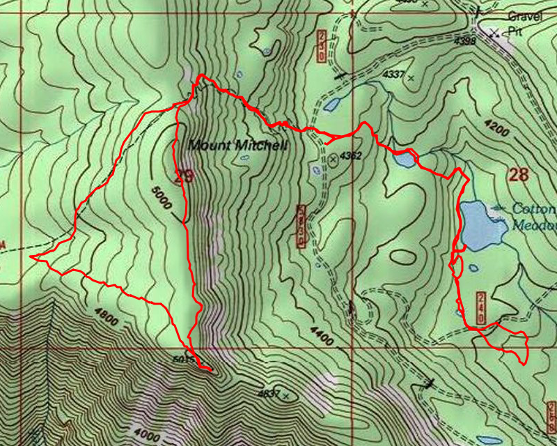
We got a bit of a late start due to my sleeping in a bit. We got to the east end of the Rimrock trail about 11:30 and headed up. The dogs were ready to go (as usual). While we were getting ready, they were running back and forth down the 5830 road like maniacs. They probably hiked 2 or 3 times as far as we did….
Anyway, we headed up the east side – the hill is pretty steep in places, so we quickly got our hearts racing. The trail was relatively clear (this side doesn’t get a lot of traffic). Part way up the hill, we encountered a little bit of snow:

When we got to the top, at the rockslide, we got a pretty good view of the Shellrock creek drainage:

From there, we continued up the hill to the overlook trail junction, and then headed up to the overlook. I think the last time I was here was in the middle of winter when you could barely see the trail junction sign! This was almost 7 months prior:

We headed up the overlook trail and shortly got to the overlook where it was very windy. We headed out to the point, where we got some good views. This is looking south towards Mt. Jefferson and Olallie:

This is looking north towards Mt Hood:

This is looking southwest to Oak Grove Work center:

Here is a short video – It was really windy on the North/East side of the overlook – make sure to turn the volume down:
We kind of sheltered on the west side of the overlook where the wind wasn’t too bad – we ate lunch there and then headed back down. Just to make things interesting, we decided to head back along the bluff. It was quite a bit shorter and it looked pretty open and was a straight shot back to the trail (instead of going down and then back up). It turned out to be relatively easy walking, other than going over a bunch of downed logs. We soon made it back to the trail near the rocklide and then continued down. On the way back down, we saw several of these blazes – two on bottom and one on top – but weren’t sure what they meant:

We quickly got back to the truck (around 2:00) and then headed across the road to the Cottonwood Meadows trail. This is what greeted us near the beginning of the trail:

We went around the frozen spot (it wasn’t thick enough to walk on I don’t think). We continued down the trail and then explored a short alternate for the trail that ended up pretty much heading back up to the road. Not sure if it was an old alignment or what. As we continued down the trail, we soon got to the first meadow – we obviously had to go around – even the dogs didn’t want to go thru it – not sure how deep it was, but it was more than ankle deep for sure:

We continued around that meadow/swamp and soon came to the big swamp/lake – Cottonwood Meadow Lake? (not sure what it is called). We took the route on the west side of the lake, continued south and had to route around another wet area, finally coming to the large meadow north of the 5830-240 spur road. This is essentially the end of the trail until you get down to the 265 spur, where the beautiful south end of the trail exists. We didn’t go that far since we didn’t have enough time. We headed cross country a bit to explore the area – we went down the road a bit and then headed south where it seemed more open. It was for the most part, but was still rough going. We were running out of daylight, so we headed back up the hill – we didn’t really want to hike in the dark – we knew it would get cold really quickly once the sun went down.
We headed back up to the road, then back up thru the meadow. Just before the big lake, we saw some branches piled in the trail with a flag – it kind of looked like a trail, so we followed it around to a campsite on the south end of the lake. There was a boat there (I had seen it a few years ago on the west side of the lake). There was about an inch thick of ice on the south end of the lake (the dogs were walking all over the ice – we didn’t go too far out):

And here is Cottonwood Meadows Lake from this south end campsite – you can see the ice part way out – I don’t think this end of the lake gets any sun this time of year:

After exploring this campsite for a few minutes, we continued back up the hill. We made good time and got back to the truck just before 4:00. We loaded up and headed out. As we drove out, we decided to explore the 210 spur – I took this photo part way down the spur road. This was where we were earlier in the day – the overlook is to the left, Mount Mitchell proper is to the right:

We went down the spur pretty much to the end. We were hoping there might be some sort of view, but things have grown up too much. It was interesting – part way down, the road went thru some uncut area that was really pretty. It had a campsite next to the road. We turned around and headed back. As we were driving, the sun went down – by the time we got back to Estacada, it was pretty much dark. We stopped at Fearless for a burger and a beer. The perfect way to end a good day of exploration!