
| Date | 5/11/2019 |
| Location / Trail | Memaloose Lake Trail - 515 |
| Weather | Sunny and warm |
| Hiking Buddies | Kirk, Ollie and Thor |
| Start / End | 11:05 AM – 3:30 PM |
| Distance / Elev | 3.6 miles 1500 ft elevation |
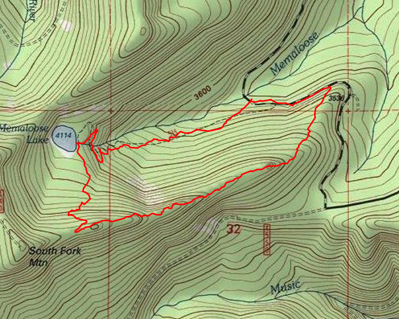
We decided to see if we could get up to Memaloose Lake, which is a little bit lower in elevation. Fortunately, we ran into almost no snow, and the few short spots we encountered were easily passable. We got to the trailhead and started getting ready, when another car pulled up. I was a bit surprised to see another car this far up this early in the season, but I knew we would have company. We shortly headed up the trail, which was littered with branches and detritus from the winter – it didn’t look like anyone had cleared anything yet this year, so we threw a bunch of branches off the trail as we headed up. We stopped at one of the switchbacks where the creek is near the trail and the folks from the car we saw passed up – they were a couple of trail runners, so were moving pretty quickly. We soon made it up to Memaloose Lake that still had lots of snow:

We stopped at the campsite next to the lake and had lunch. We decided to try and head up the trail up to South Fork Mountain to see how far we could get. There was patchy snow on the unmaintained trail:

When this trail finally hits the ridge up to South Fork Mountain, an old abandoned trail joined it – the South Fork Mountain trail headed west and the trail to Wanderers Peak went east. We decided to explore a bit of this abandoned trail – initially we were just going to go a little ways and then return and go up to the top of South Fork Mountain, but as we proceeded down the ridge, we finally realized we didn’t really want to go back the way we came, so we decided to continue down the ridge looking for blazes and tread and eventually come out on the 45 road and then walk back to the trailhead.
As we proceeded down the ridge, the side hill got steeper and steeper – we got concerned we were going to get cliffed out, but we continued to make progress, although it was pretty slow. Here is an example of some of the SERIOUS side hill action going out the ridge on the old Wanderers Peak trail:

At the end of one of the somewhat flat ridge lines, there was a bit of a knob. We climbed over to it and didn’t get as good of a view as we were hoping. This was a cool rock formation looking back at Memaloose Lake (hidden behind trees) from that little knob:

A little farther down the ridge, we came to this cool ridge top meadow:

And a little farther we came across a knob (it actually shows as a small knob on the map). We climbed to the top of it and found great views. Mt Hood and Mt Adams to the north:

Hard to see peak of Mt Jefferson and Olallie Butte to the south:

We climbed back down and continued traversing the steep side hill, which got slightly better as we got closer to the road. We ended up following a second ridge down to the road, which was a little easier. We finally made it back to the road and walked back to the trailhead. Unfortunately, there was almost no trail left that we could find. A few blazes here and there and a few short sections of tread were found, but large sections were without any blazes and many of the sections where there would have been tread are so steep we figured that the tread has probably slipped down the hill.
We got back to the truck about 3:30, so we decided to head farther up 45 to see what conditions looked like. When we got to the 4550 junction, it was obvious that someone had spent some serious time brushing out the road:

We decided to head down it to see how far we could get, wondering if we could make it to the waterfall at Music creek. We made it there, but just past the first campsite, the road was impassible due to snow on the road again. We walked down to the creek, and got a great view of Music Creek falls running loud and fast:

Here is a short Video – it was rather LOUD:
After watching the waterfall for a little while, we headed back up. I walked up the road a bit to see if the brushing continued – it appeared to have stopped at Music creek, but it was hard to tell. Once the road re-opens, it will be interesting to see what it looks like. We walked back to the truck and headed out. On the way home, we took a short detour so that I could show Kirk the remains of the Silvicultural research area – I’d investigated this area several years ago – it is an interesting area where they studied ways to make trees grow better/taller/faster, but it has been closed for at least 10 years I think. There isn’t much left except for some remnants of the buildings and all the fences and trees they planted.
We stopped at Fearless in Estacada for a burger and a beer. What a great way to cap off a great day of exploring!