
| Date | 7/13-7/18/2019 |
| Location / Trail | Three Sisters Wilderness |
| Weather | Varied from sunny and warm to cold and windy with some rain |
| Hiking Buddies | Carly, Kirk, Sarah, Jeff |
| Distance / Elev | 68.6 miles 16,000 ft elevation |
Originally we were thinking about going to Glacier National Park in Montana, but we realized that we needed permits (kind of like when we did the enchantments) and it was too late this year to get them. We decided to do the Three Sisters loop because next year this entire wilderness will be permits only (like the Enchantments and Glacier) and will be more difficult to get into. I knew before even starting that this was going to be a challenging trip (due to the length and elevation). This was the longest backpacking trip I have ever taken, both in duration and mileage. The initial plan was this:
- Day 1 – Lava Camp Trailhead to Alder Creek – About 6.5 miles
- Day 2 – Alder Creek to Camp Lake – About 9 miles
- Day 3 – Camp Lake to the summit of Middle Sister and then back out to Park Meadow – About 12 miles
- Day 4 – Park Meadow to Mesa Creek – About 11.5 miles
- Day 5 – Mesa Creek to Minnie Scott Springs – About 12 miles
- Day 6 – Minnie Scott Springs to Lava Camp Trailhead – About 6 miles
- Total Mileage: About 57 miles
What we actually did was significantly different than the plan, and considerably more mileage than estimated. We added a side trip up to Broken top and some of the distances I calculated were a bit off. This is what we actually did, with actual mileages:
- Day 1 – Lava Camp Trailhead to Alder Creek – 7.5 miles
- Day 2 – Alder Creek to Camp Lake – 10 miles
- Day 3 – Camp Lake to the summit of Middle Sister and then to an un-named lake – 12 miles
- Day 4 – Un-Named Lake to Moraine Lake with a side trip to the top of Broken Top – About 13.5 miles
- Day 5 – Moraine Lake to Sawyer Bar – just short of Opie Dildock Pass (what a name!) – About 17.5 miles
- Day 6 – Sawyer Bar to Lava Camp Trailhead – About 7.5 miles
- Total Mileage: About 68 miles
Day 1 – Lava Camp Trailhead to Alder Creek
The “Blue Adventure Bus” (Kirk’s van) came and picked Carly and I up about 8:30 on Saturday morning. Kirk had already picked up Jeff. The plan was to head out, have lunch on the way, and then get on the trail shortly after 1:00 or so which is why day 1 was shorter mileage (same for the last day).
We ended up stopping for lunch in Detroit since that was really the last slice of civilization with a decent restaurant before the trailhead (even though it was like an hour and a half away). We had lunch at a restaurant called Cedars – It was good to have one last “real” meal before heading out into the wilderness. We ate an early lunch and then continued to the trailhead at the Lava Camp Trailhead on highway 242 near McKenzie Pass. We passed the Dee Wright Observatory which would be an interesting place to explore some day. It is in the middle of a HUGE lava field. I had never realized how much lava there is in this area. We would be seeing more of it as the week progressed.
The other really interesting/weird thing that happened on the way to the trailhead was there were TONS of butterflies on the road. There was literally a swarm of them in places – there were so many we kept hearing “splat” when one would hit the windshield or the front of the van. It was really kind of strange to see SO many butterflies.
After the butterfly massacre, we shortly got to the trailhead and got all our gear on for the start of our 6 days in the wilderness.
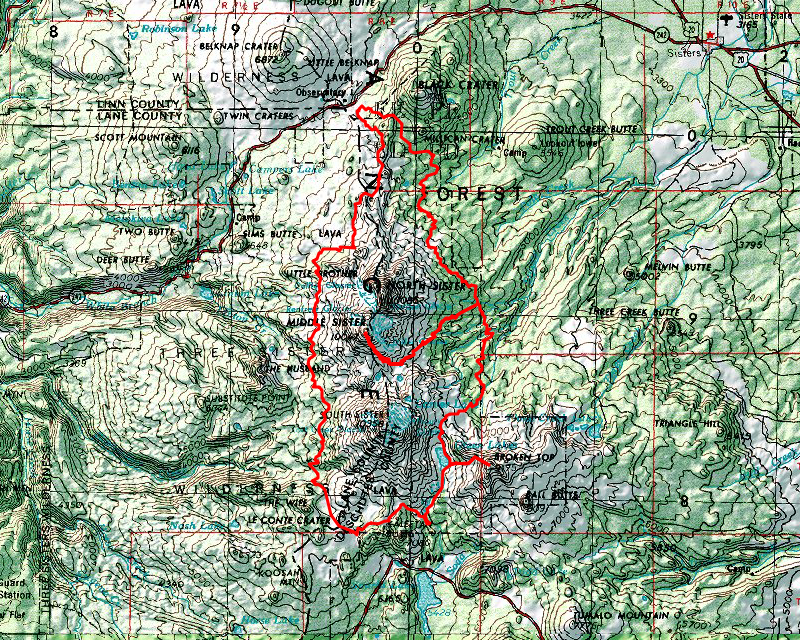
We headed down the Millican Crater Trail (4066) – originally I thought we were going to go down the PCT for the first part of the trail, but we found this would make the trip a true loop – we wouldn’t be repeating any part of the trail with the exception of the trip in and out of Camp Lake. We headed down the trail and very quickly came into the burn area. This has been the site of at least a couple of rather large fires – I think one of the latest ones was the Pole Creek fire in 2012 and burned about 26,000 acres. The last one was just last year and was over 101,000 acres! We saw lots of this (and worse) all day long (and into the following day too):

When we got to to the Trout Creek Tie Trail (4067) we took a turn south and headed to Trout Creek. We had a snack there and got water and then continued on the Green Lakes Trail (17). Shortly before Alder Creek (our destination for the night), we got this view of Millican Crater in the foreground with Black Crater behind it:

And a little farther we also caught our first glimpse of North Sister:

Soon we made it to Alder creek and started looking for a campsite. We found one just up the hill from the creek. We were expecting to see some other people but didn’t see anyone camped there at all. Here was our campsite for night 1:

After setting up camp, we cooked dinner, cleaned up and then went to bed.
Day 2 – Alder Creek to Camp Lake
We got up and got going about 8:30 on Day 2, heading to Camp Lake. Shortly after leaving camp, we got a much better look at North Sister:

A little farther down the trail, we got a pretty good look at Mt Washington:

A little farther we got our first real look at South Sister thru the burned trees:

We continued down the trail until we got to the Camp Lake Trail junction and headed west. It was somewhere in this vicinity where I started noticing the mosquitoes more – maybe it was where we came out of the burned area into woods, I’m not sure. I just know that at some point, the bugs started becoming quite annoying, especially when you weren’t moving.
We continued down the Camp Lake trail and we originally thought this creek was Squaw/Whychus creek, but it turned out to be an un-named creek crossing – but it was a great source of cool, clear water:

Shortly after the un-named creek crossing we came to the actual North Fork of Squaw/Whychus creek – here is our group starting to cross it:

A little bit down the trail we got our first really good look at North Sister as well:

Shortly after that view, we started to hit significant snow, which obscured the trail in many spots. We were able to find our way thru (there were little to no footprints to guide us), and soon made it to Camp Lake – which still had quite a bit of snow and was rather un-inviting, windy and cold:

We looked around and set up our tents about the only place we could find to camp – and turned out to be probably the worst place since the wind came from the south across the lake and funneled thru the small opening on the north end of the lake:

We also got a good look at Middle sister above Camp Lake, which would be our objective for the following morning:

We setup camp but as we were setting up camp, one of the poles on Carly’s tent broke. We made a “fix” using some duct tape and were hoping it would hold up in the wind (more on that in a minute). After getting our tents setup we made dinner crouched behind the hills next to our tents – we found enough space to cook out of most of the wind.
We also noticed the huge slabs of snow that were calving off into the lake on the south side of the lake. We would regularly hear one of them crash into the water.
The most significant thing that happened on Day 2 was probably at night. After we cleaned up after dinner we went to bed. It had started to mist a bit and the wind had picked up. We were also planning to get up at 5 to get going up to Middle Sister early – so we would still have enough time to make it to Park Meadow. Shortly after we went to bed, the wind REALLY picked up and was blowing our tent in about a foot when it gusted hard. Some of the gusts were REALLY strong (like 40 MPH+ I think) and we were worried that our cheap tent pole fix would collapse during the night. Fortunately, it held up just fine, but no one got a lot of sleep that night due to the wind. It was the stormiest night I’ve ever spent in a tent.
Day 3 – Camp Lake to the summit of Middle Sister and then to an un-named lake
We got up early (5am), made breakfast and headed out to summit middle sister. There isn’t a trail up to the summit, but Kirk had climbed this peak at least a couple of times before. We kind of picked our path up the hill, choosing what looked like the easiest route. Here is a shot looking back at Camp Lake after we had climbed a bit:

A little bit further up the mountain we started to get into real snow (and the clouds) – we would mostly be in the clouds the rest of the climb – that hill is a lot steeper than it looks in the picture:

We kept climbing and when we got about half way up this was our view – it didn’t look like we had too far to go, but it got harder as we got higher – it was very deceiving:

As we were ascending, someone noticed that South Sister briefly peeked thru the clouds:

After a long, slow climb, we finally made it to the top of Middle Sister, but we were entirely in the clouds. Amazingly it wasn’t very windy when we were up there. We had no views whatsoever:

We spent a few minutes sheltered behind a big rock up on top and looked around a bit and then headed down. As we headed down, it started to really rain. Prior to that it was just misty due to the clouds. The rain was coming down sideways and was really cold. I was kind of expecting some snow, but we didn’t see any.
As we got farther down the hill, I got to experience a new skill – Glissading – this makes it really fast to come down the hill! (this picture was Kirk, but we all did it 3 or 4 times as we hit different snow fields):

We made it back down to camp a little after noon I think. We ate lunch and then packed up and headed out. Just before heading out, I decided to go look at the outlet to Camp Lake. I found this cool little snow tunnel made by the outlet – notice how much snow there is still on the hill:

And then there was this rock with some weird inscriptions at the outlet – I have no idea what it means:

I think we started our journey out about 2pm – we had a ways to go. We weren’t sure if we would be able to make it to Park Meadow, but we figured we would see how the day went.
As we were hiking out, I noticed some neat cliffs that I had not noticed on the way in:

The trip out was pretty uneventful. We made it back to the Green Lakes trail and then headed south. We got back into burned areas and kept hiking south. We were all getting tired and were ready to find a place to camp. We came across a pair of small, un-named lakes, and decided this would be a good spot to camp for the night – it was at least partially unburned, which was nice:

When we first arrived it seemed like there weren’t many bugs, but I think it was just that they hadn’t noticed us yet, as they arrived after we had been there for a bit. The bugs on this trip were pretty much unavoidable – the only things that mitigated them was having a breeze, keeping moving or bug spray.
We setup camp, cooked dinner and went to bed. We were planning on getting another early start as we added a summit of Broken top to our itinerary for the following day.
Day 4 – Un-Named Lake to Moraine Lake with a side trip to the top of Broken Top
We got up early again to get an early start. The plan was to hike to the junction with the climbers trail to the top of Broken Top, drop our packs and then head up. Once we summitted Broken Top, we would come back down and then head south to camp for the night. We were thinking maybe Moraine Lake would be a good spot because the next water was quite a ways from Moraine Lake and we didn’t think we would be able to do an additional 4 miles to get to the next water source.
We got going a little after 7am and continued south on the Green Lakes trail. We finally got to Park Meadow (glad we didn’t try and make it here the night before). The maps were conflicting about trails. Apparently there has been some re-routes and some trails are no longer active, so it made for some confusion about where to go. Park Meadow was a nice place, though (even though the bugs were pretty bad):

We didn’t stay there long – we continued south on the Green Lakes trail. A little further down the trail, we got a good view of Broken Top – our objective for later in the day:

We continued south and soon saw the big Green Lake (there are at least 3 of them):

We stopped here for some water and a rest – we saw a few more people here than we had the rest of the trip. Green Lakes is one of the more popular places it seems.
We got a different view of South Sister from Green Lakes – a perspective you don’t see from the south:

We got to where we thought the climbers trail was (near campsite 10) and dropped our packs in the woods up the hill a bit and then headed up the trail about 10:30. This was the beginning of the trail – it was VERY steep – but it only got worse as we got up higher:

After what seemed like forever (at least for me) climbing up some VERY steep grades (some were literally straight uphill), we got to the saddle, where the trail transitioned to climbing the ridge on the northwest side of the mountain all the way to the top:

On the way up the ridge, we started seeing wave after wave of thousands of butterflies. Here is a video where you can get an idea – the butterflies are hard to see, but you can see some of them. (they are the black spots in the video) It was pretty amazing:
A little further up the hill there was a view to the northeast of this amazing hillside. I wish this picture had turned out better – the colors were VERY vibrant – I still don’t know what it is:

After a LOT of breaks, and huffing and puffing (at least by me) we finally made it to a small ledge near the top of Broken Top. There really wasn’t a safe way to go any farther without ropes – it was steep and narrow ledges with cliffs with small cracks you’d have to climb to get higher. Some cool views from the ledge – The big lava flow south of Green Lakes:

And a reasonably un-obscured view of the three sisters:

Here is a 360 photo from the top of Broken Top.
While the rest of us rested on the ledge and enjoyed the view, Kirk poked around and found a rather dangerous way to the top of the mountain:

Although he required some spotting assistance on the way back down – he couldn’t see his feet to climb back down the crack he went up on. I’m very glad he made it back down safely.
We stayed on the ledge for a half hour or so (waiting for Kirk to come down) and then headed back down the way we came. On the way down, I took a photo of this interesting rock we had noticed on the way up. Kirk thought it looked like a Chinese cat – I think it kind of looks like Garfield the cat:

As usual, the trip down was quite a bit faster than the trip up. We got back down about 3:30 (about a 5 hour trip up and down the mountain) and rested at the bottom for a few minutes before loading up our packs and heading south. We continued south on the Green Lakes trail. We started following one of the lava flows along Fall Creek (I think one is called the Newberry Lava Flow):

We continued south to the junction with another trail which then took us west over to Moraine Lake. This trail gained a few hundred feet of elevation and after the ascent of Broken Top, and all the other hiking, I was pretty tired. It took me longer than everyone else to get to the lake.
We finally got there and looked for a campsite (a post) to use. We ended up finding two since the sites were small. This was our site we shared with Jeff:

It was somewhat windy at Moraine Lake, but nothing like it had been at Camp Lake. Kirk decided to go for a quick swim, although he could only stand it for like 3 minutes it was so cold. He had to try and warm up once back at camp and there were no campfires allowed.
We made dinner and went to bed early again, as the next day was going to be a long one. We needed to make up some time that we had lost due to the extra side trip up Broken Top. We had 25 miles to get back to the van and we figured we would need to do 17 or 18 miles in order to make the last day reasonable enough to get home by dinner time. We had another very full day planned.
Day 5 – Moraine Lake to Sawyer Bar
We started day 5 very early like many of our other days. This day would be all about racking up mileage – no big highlights on this day, but a few interesting things did happen.
We got going about 8:00 and headed west on the confusing array of trails around Moraine Lake. On the way, we noticed this cool Lenticular cloud over South Sister:

It was a bit chilly to hike, but that just makes you sweat less. We continued west, trying to figure out all the confusing trail junctions (we were successful and didn’t have to turn around or anything) About a mile or so from the junction with the PCT, there was this bug that just buried himself half way in the trail – have no idea what kind of bug or why – it was just weird:

We continued on the trail and it starts looping north. Soon, it joins the PCT. As the trails were getting closer, we saw 3 hikers on the PCT. We met them almost exactly where the two trails joined. They stopped and we chatted for a bit. There were two guys and a woman. One man was from New Zealand, the other from Alabama, and we never did quite get where the woman was from. They were thru hiking the PCT and taking their time. They had been out for I think 115 days and he said they were expecting to be out another 115 days. He made it quite clear they were there for the experience. It was an interesting conversation.
After chatting with the PCTers for a bit, we continued on while they rested some more at the junction. We would see them one more time and then we passed them up. A little further up the trail, we hiked along side the Rock Mesa (Lava flow) to our right – it was another HUGE lava flow:

A little further north we came to a neat Meadow near Mesa Springs. This was our original campsite on the 4th night. It is too bad the flowers don’t pop in this photo, they were really gorgeous and colorful:

We stopped at this meadow and filled up with water and rested a bit. The PCT hikers we met earlier passed us as this point. After a little while, we headed out, continuing our journey north. A little further down the trail, we passed them again – that was the last time we saw them.
Nothing terribly exciting happened for a while – we were just trying to rack up some mileage (I kind of felt like a “real” PCT hiker who has to keep moving in order to complete the trail).
We stopped for lunch at Hinton Creek – at first, we were the only ones there, but soon, 3 new PCT hikers showed up. Two women and an older man. One woman was from Germany, one was from Austraiia and the man was from Tampa. Interesting mix. We chatted a bit. They were expecting to be complete with the trail in about a month. Much faster than the other 3 we met. We had lunch, got some more water and then headed out.
A few miles up the trail we got a great view of The Husband (I don’t think we could see The Wife from the trail):

We continued north and soon found ourselves entering the Obsidian Limited use area (Kirk had a permit for us). We didn’t see anyone else there, however and no one checked our permit. About a mile or so into the area, we came to Obsidian Falls, which was really interesting. The waterfall was all set on layers of black obsidian:

Here is a video of the falls in action:
We didn’t stay there too long as the bugs were especially bad. We quickly headed up over the falls into a flat area that had some really neat cliffs:

We continued north and in about a mile, we saw one of the special memorial Plaques up on a hillside (it is almost impossible to see in this photo):

I believe this is the one for Harley H. Prouty – there are 3 of them and all appear to be related to the Mazamas somehow. We couldn’t read this one – it was too far away and we didn’t want to stop to try and read it.
We continued heading north thinking we would stop somewhere before Opie Dildock pass – we thought we would camp in the first place after the Obsidian Limited use area we could find. The first place that was really anywhere we could camp was called Sawyer Bar, which is just Below Opie Dildock Pass – this was our campsite:

Soon after we got the tents setup, the clouds moved in and it started lightly misting. We made dinner and went to bed early again. We wanted to get another early start to make sure we got out on time. This would be our last night in the wilderness.
Day 6 – Sawyer Bar to Lava Camp Trailhead
We woke up early again on day 6 to get an early start. The last morning was a lot tougher than the prior ones. Overnight it went from a light mist to real rain. It rained rather hard at times but by morning, it was mostly just misting (mostly). But our tents were all soaking wet and had to be packed up wet. The good news was that we wouldn’t need them again, so other than some additional weight it wasn’t too bad. Well, that and eating in the rain.
We made breakfast as best we could and got packed up. We then headed up the trail in the rain and wind thru the lava up to Opie Dildock Pass (what a name!? I wonder who it was named after?):

It is a very steep trail that zigs and zags thru the lava flow up to the pass where the trail flattens out for a bit and then starts heading down the other side. It isn’t too far before you get to Minnie Scott Springs (our original target for night 5):

It was wet – really wet but it looked like there were nice campsites there. But I’m glad we camped where we did. After hiking almost 18 miles the day before, doing this pass would have been very difficult. It was a lot easier to do it in the morning after a good nights sleep. We made it thru the pass and then started our slow downhill (mostly) to the van. We had a very steep uphill section near the Yapoah Crater, but we couldn’t see much. I thought the trail routing was really weird. We went up just to come right back down. Anyway, there was lots and lots of this stuff that we went thru – but this was where the weather finally started clearing up a bit:

And shortly after exiting all the lava, we came to South Matthieu Lake (we also passed North Matthiew Lake but we only saw it from high above):

Kirk decided to take the “low road” going down to North Matthiew Lake while we took the PCT (the “high road”). We had thought we might have to gain back a bunch of elevation if we went down to the lake, but apparently not. That route was slightly shorter and Kirk was there waiting for us when we got to the junction. Apparently the downhill was just mostly all at the start.
Shortly after that junction, we got to the last short connector trail to the Lava Creek trailhead and back to the van. We got to the van about 10:30am, so we made good time. It took us just under 3 hours to do about 7.5 miles. After cleaning up a bit and packing up all of our stuff, we headed to Three Creeks Brewing in Sisters for a well deserved post trip meal before our drive home.
A truly epic adventure!