
| Date | 8/31/2019 |
| Location / Trail | Pacific Crest Trail - 2000 |
| Weather | Sunny |
| Hiking Buddies | Thor |
| Start / End | 11:00 AM – 5:30 PM |
| Distance / Elev | 12 miles 3000 ft elevation |
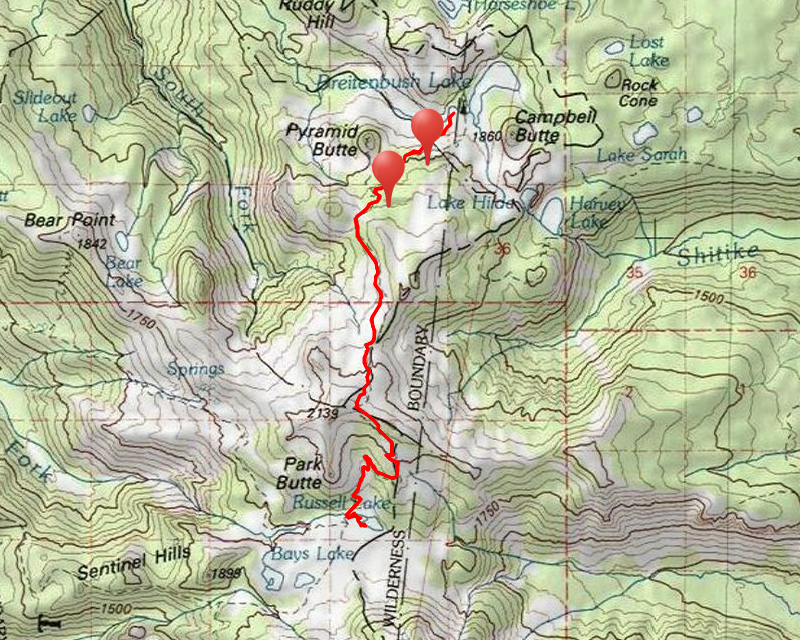
Thor and I made the long drive to the trailhead, the Breitenbush trailhead on the PCT – it is almost a 2 hour drive and the last 5 or 6 miles are down the pretty rough 4220 road. We got to the trailhead a little before 11. There was a man and his wife getting ready but only a few cars were there (maybe 4 or 5). We quickly got ready and headed out.
A short ways down the trail, we go this really good look at Ruddy Hill, Pyramid Butte, Mt Hood and Olallie (in the trees):

Then looking northwest we got a view of all the peaks in the Bull of the Woods Wilderness (Battle Ax is the easiest to see – to the left – Schreiner Peak is the tallest peak to the right center of the photo):

We continued south on the trail, meeting a few people, including some PCT thru hikers. We went thru the first burned area and missed the junction with the trail to Pyramid Butte (we saw it on the way back). We made pretty good time and soon were almost up to Park Ridge where we got a good view of Mt Hood and Olallie Butte – you don’t see this side of Olallie too much as it shows the steep drop off on the east side of the butte:

Just below Park Ridge there was a small snow field next to the trail and Thor spent a while doing his “beaver” thing in the snow. We were in the sun a lot of the day and he had been getting hot, so I’m sure the cool snow felt good to him. I should have taken a photo.
We finally made it to Park Ridge – the high point of the hike. We stopped there for lunch, where there were quite a few people stopped. We found a spot in the shade where we ate lunch and I took a photo of Thor being Thor:

After eating lunch I walked around the ridge looking for the old sign that marked the entrance into the Willamette National Forest. We saw it back in 2012:

I had heard that it had disappeared and it certainly has. I think I found the logs that made up the frame of the sign, but no traces of the sign itself could be found. I’m wondering if the Forest Service came and got it or something as a historical artifact. Anyway, it is sad it is gone – it was a cool piece of history since it still said Skyline Trail. I’m glad I got to see it before it disappeared.
After looking for the sign for a bit, we headed down the trail into Jefferson Park. There was this great view of Mt Jefferson while we were descending into Jefferson Park:

And a little farther down the trail we started getting into Jefferson Park for real – it is very beautiful-green and lush, even in August:

It wasn’t long before we made it to the shore of Russell Lake:

There were a LOT of people milling around the area, and we saw a few tents there. We stopped in a shady spot and I wanted to just enjoy the scenery for a bit but Thor got restless. I took one last photo of Russell Lake beneath Mt Jefferson

and then we headed out. There are a LOT of user trails in Jefferson Park so we had to find our way out. As we were heading up and out, I took another photo of Mt Jefferson rising above Jefferson Park – I never get tired of that view:

We then headed back up the trail – it is rather steep farther down and gets a little more graded as you get up the hill.
We were almost back up to the top of Park Ridge when we finally met Kirk and Sarah. It was about 3:45 and we still had a ways to hike back. Ollie and Thor had fun playing for a few minutes and we all talked for a bit and then Thor and I headed up and Kirk, Sarah and Ollie headed down. They had camped before Park Ridge at one of the small tarns. Since they didn’t have too far to get back they still had a lot of time to explore before dark.
We got back up to Park Ridge and this time there were only a few people up there. We crossed over the ridge and headed down the other side. I caught this picture just below the ridge where you can see Eastern Oregon pretty well (although it was a lot easier to see in person):

Thor played in the same snow field he did on the way up – he was getting pretty hot – being in the sun most of the day. It is tough having black fur!!!
We made good time and on the way down, I took a photo of this cool rock formation that I had seen on the way up (but neglected to photograph):

There wasn’t a whole lot that stuck out on the way down. Since it was getting late, we were just trying to make time so that we wouldn’t be getting home too late. We met a few people on the way back, but it was a lot quieter on the way back than the way in. I could tell Thor was getting really tired. I was tired too, but we still had a mile or two to go, so I had to encourage him a bit to keep going. We stopped a few times so he could rest – I checked his pads in case he wore them off like he did a couple months ago on a very rocky hike. He was fine, just tired, so we took it slow and took a few rest stops.
We finally made it back to the truck about 5:30pm – that last mile seemed to stretch on forever! We loaded up and started the long bumpy road home.
I always love Jefferson Park. It was a good day in the woods.