
| Date | 12/14/2019 |
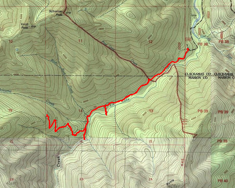
| Location / Trail | Elk Lake Creek/Welcome Lakes Trail - 519, 554 |
| Weather | Overcast with a few sunbreaks |
| Hiking Buddies | Kirk, Ollie and Thor |
| Start / End | 10:45 AM – 3:40 PM |
| Distance / Elev | 7.8 miles 2300 ft elevation |
We headed out about 9:00 and made it to the trailhead about 10:30 or so. I was surprised to see another vehicle there. We suited up – it was rather chilly (34 degrees or so) and headed up the trail. The trail starts out in an old clearcut and shortly opens out into the burned area from the 2008/2010 (I’m not sure which was where) fire. Here is a map showing the three different fires that have affected the Bull of the Woods Wilderness recently:

And this is what the beginning of the trail looks like thru the fire damaged area – lots of burned out trees but a few survivors, especially down by the creek:

A short ways in, you come to a really cool area – the creek takes more than a 90 degree bend and there is a nice waterfall – it was flowing very fast and loud today:

And here is a short video of the waterfall – you can hear how loud it was:
As we were hiking thru this area, I noticed quite a few young trees popping up all over the place – they are somewhat hard to see in this photo (all my photos were kind of washed out on this trip – maybe because it was so overcast and foggy) – here are some of the new sprouts:

We continued up the trail, doing a little bit of trail maintenance as we went – trying to make passage over some of the logs easier. Soon, we got to the Pine Cone Creek Crossing, which is where the Bull of the Woods Wilderness boundary is:

We continued up the trail and soon got got an unmarked side trail which we believe is the old trail over to Janus Butte. I had gone down this trail a few years ago and explored a bit – we decided to go down and to have lunch by the creek. This is what it looked like:

When looking at it, we wondered if this was a ford spot – it doesn’t look quite natural and somewhere they would have had to ford the creek to continue up the other side. That exploration would have to wait for another day, however. The water was too fast and deep to cross today.
We ate lunch next to the creek, did a little more exploring of the campsite there and then headed back up to the trail. We continued a bit farther to the Knob Rock Creek Crossing-this was a little challenging due to the volume of water coming thru here:

Right above the crossing there is a very nice waterfall:

And here is a short video of the waterfall – it was running pretty fast and loud:
We expected there to be some distance between the Knob Rock Creek and Welcome Creek crossings, but they are almost next to each other. The maps are not quite correct. I don’t know if winter storms have changed their courses or what, but they are VERY close to each other now. This is the much easier Welcome creek crossing:

After crossing these two creeks we very quickly came to the Welcome Lakes junction. We decided to go down to the Elk Lake Creek crossing just to see what it looked like. It is not very far from the Welcome Lakes junction. We headed down there and quickly got to the first crossing point:

I’ve crossed here at least twice – but always in the summer when the water is much lower. Even then, it is at least 6″ deep. I’d guess the water was 18″+ deep and it was pretty cold. We opted not to attempt crossing it. So, we turned around back to the Welcome Lakes junction and headed up that to see how far we could get.
The first half mile or so of the trail is in un-burned territory but is getting rather brushy in places. It goes uphill at a pretty good rate, so it was somewhat challenging. After the first half mile of wooded terrain, we started to break out into the burned area. From here is got even more challenging due to all the downed logs and washed out tread sections. Part way up, Kirk noticed Janus Butte to our southeast:

The one thing that the fire did is to open up a lot more views on this trail. Although there are a LOT of snags, you can see out across the valley – pre-fire this section of trail would have been in heavy forest cover.
There are a few VERY messy sections in this area like this (yes, there is tread under all those trees):

We headed up a little farther and got a pretty good look at Schreiner and Knob Peaks too:

And looking east, we could see a bit of Rho Ridge:

We continued up, seeing just a hint of snow here and there and doing a little bit of trail maintenance where we could, although most of it was not work for a handsaw. We made it up to about 3500′ and decided we should turn around – I was hoping we might be able to get to Welcome Lakes but the days are short and I didn’t want to hike in the dark. This trail is quite a workout between the elevation gain and all the downed logs. I wouldn’t be surprised if we encountered 100 downed logs in the mile of the trail we hiked.
The trip down was pretty uneventful – we did a little more work up high on Welcome Lakes, but soon decided we needed to just push to get out before dark. We made it back to the truck a little before 4:00 – it was already starting to get dark. When we got back to the truck, the vehicle that was there when we arrived was gone. We never saw anyone else all day long so I’m not sure where we crossed. Maybe they were farther up the trail, or maybe they came back while we were down at the creek or up Welcome Lakes or something. It was nice having the trail to ourselves all day long, however.
A stop at Fearless on the way home was a great way to finish a nice day of exploring an interesting area.