
| Date | 12/23/2019 |
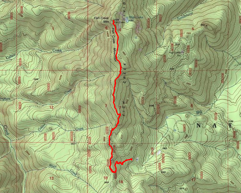
| Location / Trail | Fish Creek Mountain Trail - 541 |
| Weather | Overcast and Cold with a couple of sunbreaks |
| Hiking Buddies | Thor |
| Start / End | 11:20 AM – 2:50 PM |
| Distance / Elev | 6 miles 2100 ft elevation |

and some shots down the South Fork of the Clackamas drainage (as much as you could see – it was pretty foggy):

Since Plan A and Plan B both were foiled, I had to figure out where to go. I could have hiked Hillockburn, but I wasn’t in the mood for that short of a hike and I wanted to see a little bit of snow. I thought I would try to see if I could get to the Fish Creek Mountain trailhead (which was about 3100′). If that wasn’t available, I figured I could hike Cripple Creek – I know I could get to that trailhead for sure.
I was able to easily drive to the Fish Creek Mountain trailhead – it had almost no snow. I’m guessing the first row of mountains must have sucked a lot of the snow out of the storms and Fish Creek didn’t get as much. Or something like that. There was just a tiny bit in the trees, but nothing on the roads. I’m also glad I got my Garmin so I could send a message to Gail to let her know where I was. I told her I might have to change plans, and it is nice to be able to do that but still let her know where I will be in case something happens.
We got suited up and headed up the trail. This trail starts on an old cat road and soon joins a very old abandoned trail segment that takes you up to the ridge and the old road which then takes you to the original trailhead. While walking the old road, I saw something I’ve never seen before on this trail – an old sign:

I know it means Township 6,Range 6, Section 18, but I’m not sure what the 05 is for or what it means – it has a US Forest Service plaque on it so it must be “official” – but it is very old.
We continued up the road and soon found the old trailhead and headed up. I was surprised there was not more snow up on the ridge. It was pretty much just a dusting of snow. It was mostly foggy the whole way but the clouds did part a few times like this quick view we got:

Another unique thing on this trip I noticed was this hard to see phenomenon – ice on the BOTTOM of the branches – I thought it was snow at first, but it was ice and it was under the branches – really interesting:

We continued up the trail and really had basically no snow until about 4000′ and even there it was pretty light:

This is what most of the viewpoints looked like – foggy:

But we got to see LOTS of the white stuff! As we were hiking up, I really liked this rock outcropping covered in fresh snow:

We continued up the hill (I forgot how much uphill this trip is – it is a LOT), with the snow slowly getting deeper. As we got closer to the lookout, the snow got quite a bit deeper – but not REALLY deep – this was maybe 5-6″:

We got to the old lookout location and had some lunch. Thor did some frapping in the snow and chased some snowballs. The sun briefly tried to peek out while we were eating lunch:

And here is Thor playing in the snow:

It kind of felt like it was getting colder and the sun went away and then it started snowing!

I contemplated going down to high lake, but since the days are short, I opted to just continue down the trail and head back out. We probably could have gone down to the lake and back, but it would have been getting dark by the time we got back to the truck, so I think it was a good call to skip the side excursion today. It would have been interesting to see in the snow. I was also curious how much snow would have been down by the lake. I’m thinking it probably hasn’t had time to accumulate so there might not be much yet.
Anyway, we headed back down, making pretty good time since it was all downhill. On the way back down, I let my phone acclimate and it said it was 25 degrees! I was thinking it was more like 30-31 degrees – just below freezing. I was off by a bit!
On one of the side viewpoints on the way back down, I think I saw East Mountain:

We soon got back to the old road and made quick work of getting back down to the truck. We made it back to the truck just before 3, so we were able to make it home before it got dark.
An absolutely beautiful snowy day in the woods. Very peaceful and serene. A nice way to close out my hiking for 2019.