
| Date | 11/28/2020 |
| Location / Trail | Wildcat Mountain - 781 |
| Weather | Overcast and foggy |
| Hiking Buddies | Kirk, Ollie and Thor |
| Start / End | 9:10 AM – 2:25 PM |
| Distance / Elev | 9.1 miles 2500 ft elevation |
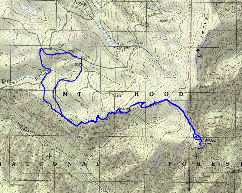
We started out a bit early since we expected to do 9-10 miles. We were right on with the estimate – we did just over 9 miles total for the day. We actually made pretty good time, getting done well before it got dark. I guess we can cover a lot more ground when we aren’t doing trail maintenance!
We got to the 255 spur about 9:00, quickly suited up and headed out. It was misting a good bit at this point, so we put on rain gear. We headed down the REALLY bad, ripped up asphalt road. A little ways down the road there appeared to be a side trail, so we tried that for a bit. It didn’t last long and we were back to the road. It got a little better after the initial aggressive ripping up, but it was still pretty tough going. It would be REALLY easy to sprain an ankle on that stuff.
We got to a point where it seemed to make sense to go cross country, trying to find the trail. This shortcut cut about 1.5 miles (maybe a bit more) off the trip since the road headed west a ways and then the trail came back east. After tromping thru the woods for a bit we found the trail – it was a pretty easy cross country trip.
Once on the trail we headed east/southeast and started making pretty good time. Soon, we came to this crossing of an un-named creek, which someone had thoughtfully placed rocks to make it an easy rock hop:

We continued thru the second growth and soon got into the old growth and into the original Wilderness area. The forest in this area is pretty impressive. Although it was foggy and misty, it was still beautiful. I think it was in this area that we encountered a bow hunter coming down.
It wasn’t too long before we arrived at the old start of this trail, the Wildcat Quarry – which is a BIG quarry:

And in the past it has had a LOT of “bad activity” – like this completely shot up sign:

The moved the trailhead north about a half mile, decommissioning the road to the quarry, but as you can see by the tracks in the snow, people still get around it. We didn’t see a lot of evidence of recent shooting in the quarry however.
We couldn’t see anything due to the fog, so we headed around the rim of the quarry and found the trail continuing east. A little farther up the trail is what appears to be a great viewpoint in better weather, but there was not much of a view today:

We continued east, and the snow continued to get deeper although there had been enough footprints in the snow that it was easy to follow. A ways up the trail we saw an opening and headed over to take a look. What we found was another unmapped road that appears to have been decommissioned – it appears to have been an undocumented spur off the 105 spur – it was a LONG road:

After investigating that road, we continued east. We soon got to the McIntyre Ridge/Douglas trail junction:

And just beyond that, I saw some wire hanging down on a tree next to the trail, and looked up and saw an insulator:

It was at about this point that the trail route became unclear – there was a definite split – most of the footprints headed on the right path, but a few headed to the left. Kirk headed up to the left and I headed to the right. It appears the tread to the left was the “old” alignment – it is a bit steeper but is more scenic on a day you had a view as it followed the edge of the cliff looking down into the Boulder Creek drainage. We finally met up where the trails re-converged and made the final push to the top of Wildcat Mountain.
It wasn’t long before we popped out on top of Wildcat Mountain. There was probably 18″ of snow on the ground and there were no views – it has grown up – it is similar to Fish Creek Mountain or Old Baldy – trees mostly ring the perimeter. I think if you headed out to the south end of the top you might have been able to see something – it appeared there was a small opening there. Here is a picture of Thor and Kirk on top of Wildcat Mountain:

We bundled up and ate lunch at the top of the mountain. But not moving, we quickly started to get cold. So, it was a pretty quick lunch. We then packed up and headed back down.
When we got to the junction of the old/new alignments, we headed down the old alignment – I hadn’t seen it and it was quite a bit shorter. In good weather, that would definitely be the preferred route I think.
We made really good time coming down. At one point, I wanted to take a photo of the forest and trail:

We soon got back to the quarry and things had cleared up a bit, so we got a tiny bit of a view looking south – down below is Eagle Creek and somewhere across in the fog would be Old Baldy:

We continued down from the quarry and headed down. On the way up, we had seen what appeared to be another undocumented road and a side trail that appeared to head up to it. We decided to take that route back, thinking it might be easier than the way we came in. That side trail was REALLY short, and put us onto that undocumented road, which we soon discovered was the extension of the 155 spur. We headed north on this spur and it was in pretty good shape – not ripped up or anything:

We walked this very nice road back up to almost the junction with the 3626 road where we had our last adventure of the day. As we were walking we heard gunshots. As we got closer I was concerned they were shooting down the spur road – fortunately, they were not shooting down the road – they were shooting off onto a “sort of” backstop – but we yelled and they heard us and stopped shooting long enough for us to get back up to the 3626 road. We walked this road back to the truck. Along the way we encountered quite a few vehicles. It appears most of them were looking for Christmas trees.
We made it back to the truck just before 2:30. The dogs were tired and so were we. We started packing up and someone asked if we were leaving – I guess they wanted to park where we were. It was kind of a weird experience to be out in the woods and feel like you were at the mall – with someone waiting for your parking spot.
All in all, it was a great day out, even with the weather and no views. I’d like to come back and do this trail again, maybe a mid week (to escape most of the crowds) hike on a nice day – where there are views.