
| Date | 11/7/2020 |
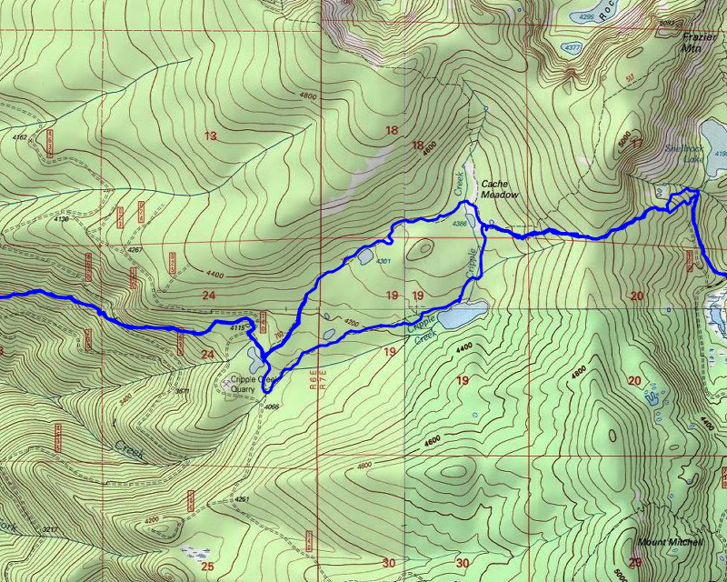
| Location / Trail | Shellrock Lake to Cache Meadow to Cripple Creek Trail - 700, 702, 703 |
| Weather | overcast and snowy |
| Hiking Buddies | Thor |
| Start / End | 10:105 AM – 4:20 PM |
| Distance / Elev | 10.5 miles 2800 ft elevation |
The days are short right now and I had to take the long way around over Mt Hood to get here – it takes about 2 hours to get to the trailhead, so I started early – I left the house at 8:00. The weather report said it would be cold, but it also said it would be “partly sunny” – that turned out to be a lie. I got off 26 and started down 42, soon getting to road 58. It climbs quite a bit and I was soon into a fair amount of snow. It kind of looked like someone had plowed the road (two tracks – it didn’t look like just driving). But it was deeper than I was expecting:

We soon made it to the junction with 4610 and I decided to drive up a bit to see what the east end of the road closure looked like – I don’t think anyone will be getting around that gate:

There was also a pretty large log deck there:

After quickly checking this out, we headed back down to 58, then down to the 5830 road and out to the Shellrock lake trailhead. As I expected, I saw no one else, nor any evidence of anyone driving out this way at all. This is what my truck looked like parked in the Shellrock Lake trailhead parking area in the morning (about 10:15):

And this is what it looked like when I returned about 4:15 – It had been snowing a lot of the day and I was concerned it would have been a lot more snow – and I would have a difficult time getting home – fortunately things were OK – I think we got about a half inch of snow during the day:

We suited up for the cold and quickly headed out. A little bit up the trail we got a really beautiful view from the trail – looking east ish:

It didn’t take Thor long to start REALLY enjoying the snow – doing his “beaver” thing in the snow – you can hardly even tell he is there – he kind of buried himself in the snow! There was probably 4-6″ of snow at this point on the trail:

We continued down the trail and soon got into the woods. It is at this point that the abandoned trail takes off to the west. There used to be a post that was a good jumping off spot – the trail going up the hill seems to have mostly disappeared but once you are up the hill a bit, it re-appears. I couldn’t find the post so we took a shot and headed up the hill – it was kind of tough going, with the snow, but we eventually found the trail and continued west. Pretty soon, we got to this junction with another abandoned trail that heads down to 5830 – I had not seen this before – but I’ve only been on this segment a couple of times:

We followed the trail thru the snow and soon came to this small lake around cache meadow:

Shortly after this small lake, we hit the junction with the Grouse Point Trail (517). Just past the junction we saw Cache Meadow proper:

And near this is a campsite where Cripple Creek Trail comes in and where there used to be a cabin – it burned in the early 2000s:

We stumbled around in the snow a bit, struggling to find the trail, but eventually found the cripple creek trail and headed south, and then took a westerly turn. At that point, we came to this lake – I’m not sure what it is called – Cripple Creek Lake? – Cripple creek feeds it and is the outlet from it, so that would make sense, but it is not labelled on any of the maps I have:

We continued down the trail, fighting a LOT of downed logs such as this – I’m guessing these might have been casualties from the Labor Day windstorm:

Soon after that tree, I found this Bear print in the snow:

And soon after, Thor found what looked to be a “deer nest” – there was deer fur all over the place – or maybe that is where a deer got eaten – I’m not sure – it sure looked like a good “den” – It sure interested Thor:

We continued down the trail – I kept looking for the trail heading north (I didn’t want to have to road walk around) – I found it and we soon got to the spot where where all the trail junctions come together with a few signs – it is very confusing:

We actually headed off in the wrong direction – heading back up the Cache Meadow trail – I soon realized my mistake and we headed back and found the correct trail – which was probably 20′ from those signs. We soon got out to the 4635 road where the Cache Meadow trail starts:

We headed a bit down the road where Cripple creek continues downhill and continued down. It wasn’t too long before we got to the spot where the trail crosses the 4635 road farther down:

Shortly after the road crossing, the trail gets into a big rockslide. It was here that we got our first look into the burned areas farther below:

We continued down the trail, thru the cut area, and soon saw the first evidence of burn damage. It started out relatively limited, and soon got worse. This is one of the more severe burn damaged areas – lots of trees downed across the trail – you can see a cut log where the trail went in the distance:

Some of it wasn’t too bad to follow, but some got tough. In many spots, the tread burned out, like this section -a big hole that was one tread:

I saw this interesting section as well – it burned on both sides of the tread but the tread itself is completely intact – It seems like in this area it was mostly a ground fire:

We continued down the trail – it kept getting harder and harder to make progress – there was a lot of stuff on the trail, a lot of downed trees (some green). I used my loppers and a bit of hand saw work to get thru some of it, but it was getting increasingly difficult. This was another example of a heavily damaged area:

It was getting close/past my turn around time (1:30) and we still had not eaten lunch. I decided that we would turn around and find a spot to eat lunch. We had been pushing hard all day long. We found a small unburned section not too far from where we turned around. We quickly ate lunch and then headed back up.
On the way up, it started to snow, even at the lower elevation where there really wasn’t any snow. I started to get worried about how much snow was falling and whether or not I’d be able to get out. We hurried our pace (as much as I could, since the beginning was mostly uphill – heading back up to Cache Meadow). It continued to snow off and on. When we got back to the confusing junction (with the signs), I decided to go back on the Cache Meadow trail instead of going back the way we came in. I wasn’t sure if it was any shorter, but it didn’t seem like it was any longer and since it has been a LONG time (2008?) since I’ve been here, I thought it would be good to have different scenery. We made it around the north side of Cache Meadow and soon got back to the Grouse Point trail near the old campsite. We went a little bit on Grouse Point to the cutoff trail – on this end it is VERY apparent – so apparent it would be easy to take the wrong turn. We headed east on the cutoff trail, heading uphill – struggling a bit to follow the trail in the snow, but keeping with it. We did well until we got to the top of the hill. There was a big downed tree, and we kind of lost the trail at that point. We went downhill, navigating a BUNCH of downed logs and finally hit the Shellrock lake trail. From there, it was easy sailing back to the truck. I had set a target of being back at the truck by 4:30 – we beat it by about 15 minutes. We quickly loaded up and headed out. I didn’t want to drive too far on the forest service roads in the dark. Fortunately, it didn’t get really dark until we got close to 26. The drive over 26 was rather interesting. It was snowing pretty hard and it was icy – the thermometer on the truck said 27 degrees and there were signs that said watch out for ice. At some point, there were trucks and what looked like some cars spun out. We successfully navigated all that, and got home safely. I think it took us almost 2.5 hours to get home, though.
It was a challenging, beautiful, COLD day. I’m glad I was able to get as far as I did. I think this is the last opportinty to get into the high country this year. It is forecast to be cold and snowy all week long – unless we get a big warm spell, I think these areas area all closed for the year now.