
| Date | 1/23/2021 |
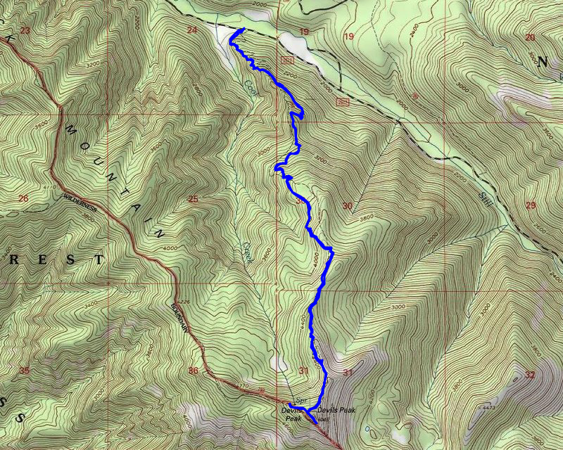
| Location / Trail | Cool Creek Trail to Devils Peak Lookout - 793 and 794 |
| Weather | Sunny |
| Hiking Buddies | Kirk, Ollie and Thor |
| Start / End | 7:20 AM – 1:35 PM |
| Distance / Elev | 7.3 miles 3500 ft elevation |
We started out very early since Kirk had to get back for a dinner party in the evening. So, we left the house a little after 6 in the dark. By the time we got to the trailhead, it was getting light enough to hike without headlamps. The traffic on 26 was pretty heavy – we were guessing lots of people headed up to the mountain to go skiing.
When we got to the trailhead there was no one else parked there. We got all suited up and loaded our snowshoes and headed up the trail. The beginning of the trail is a pretty steep ascent. The route gains over 3000′ of elevation in about 3.5 miles. The lower portion of the trail is pretty “rooty” as well, with lots of roots protruding into the tread. The tread is well worn (this trail gets a fair amount of traffic), but it can be tough on the feet with all the roots in the tread.
We made pretty good time given how much elevation we were gaining. We kept looking for a view of Mt Hood – it took quite a while, but we finally got a view – it was thru the trees, but we got a pretty good view of Mt Hood in the early morning light:

A little farther up the trail, I took this photo of the sun rising on the trail:

We continued up – it was tough due to the elevation, but we slowly made our way up. Probably about halfway up, we got our first clear view of Mt Hood – which was gleaming white:

As we continued up, I was amazed that we weren’t seeing ANY snow whatsoever. The first time we saw any real snow, it was pretty light, but it was well over 4000′ – this photo appears to be taken about 4400′ and it was pretty much a dusting of snow:

A little farther up the trail there was a large rock outcropping above the trail – we headed up to it and were rewarded with this great view of Hood:

A picture of the outcropping we were standing on:

After enjoying the view for a bit, we continued on, climbing up and up and up. At one point, I remarked that this trail reminded me a bit of the Bull of the Woods trail – the approach to the lookout felt very similar – there was a sharp knife ridge and below it the trail headed up to the lookout.
At some point, we ran into 4 guys coming down the trail. I was surprised to see them – fortunately they didn’t have any dogs with them since Thor was offleash. I was behind Kirk a bit and I heard dogs barking. At first, it sounded like Ollie, which isn’t surprising since he frequently goes off into the wood to chase a smell. I soon realized it was BOTH dogs and was worried there were other hikers with dogs. I caught up and saw the 4 backpackers coming down from the lookout. They had spent the night in the lookout and camped at the campground near the trailhead (which is why we didn’t see their vehicle at the trailhead).
We continued up the trail and soon got to the junction with the Hunchback trail, which headed up to the lookout. From the junction it was a very short trip to the lookout – this is what it looked like as we were heading up to it:

We headed up the stairs and Kirk opened up the protective panels. The inside of the lookout is mostly what it would have looked like when it was being used (except the Osborne Fire Finder isn’t in the middle of the lookout anymore):

You got a beautiful view of Mt Hood from inside the lookout – looking out the door:

We ate lunch in the lookout and then headed down to take a look around. The ridge to the south went downhill – I was wondering if the outhouse was still around (like it is at Bull of the Woods), but we didn’t find one. I did get a pretty good view of Olallie and Mt Jefferson from this sport just below the lookout:

And looking back up towards the lookout, you can see there was a fair amount of snow up there (but it was all frozen and hard):

After looking around a bit, I decided it was time to put my drone up in the air to get some videos. At that point, the wind was very calm. I’m still not great at getting videos with the drone, but here is a 360 panorama from about 50′ above the lookout:
And here is another one where I get more of a closeup of the lookout:
While we were there another guy came up – he was worried we were going to stay in the lookout (it is a first come, first served place). Since he was staying we didn’t need to close it up. A little later, two ladies popped out of the woods. They had come up a different trail – I believe it was from the Green Canyon campground up to the Hunchback trail to the lookout.
After eating lunch, exploring a bit and flying the drone a bit, we decided it was time to head back down. There is the note of a “spring” not too far from the lookout, so we decided to see if we could find it. We headed down the Hunchback trail, and found a sign saying “water” – we found a small, narrow side trail, however we didn’t go too far as the hillside was VERY steep and the trail was covered in snow. We turned around and came back up and when heading back up the Hunchback trail, we found this very old water sign (it was pretty cool):

After that exploration, we headed back up to the junction and then back down the cool springs trail. Going down was a lot easier on the lungs, but still pretty tough as the trail was still just a hunk of ice. We went slowly and finally made it out of the ice and snow. After we got back to solid ground, it was still rough going as many spots are rather steep (which is hard on the knees).
Along the way down, we probably encountered 5 or 6 groups of people who were headed up. All in all, we probably encountered 20 people all day long.
We made it back to the truck about 1:30, packed up and since we were a little earlier than expected we decided to do a little exploring – we drove up 2612 a little ways, then drove on some other roads. We got turned back a few times as bridges over creeks were closed (not sure why – maybe they were unsafe for vehicles?). We stopped and looked at the east end of the Flag Mountain trail – it looked somewhat interesting – there were no cars at the trailhead at the east end, so we thought we’d go around to the west end and see if there were any cars – maybe this is not popular trail we could hike? Anyway, we kept getting blocked from the west end – we ended up turning east on 26, but the traffic coming west was so bad we weren’t sure we would be able to turn left. So, we opted to skip it for the day. We turned around and finally get in line with the traffic. It was a solid line of cars coming west – and that was only at like 2:30! I can’t imagine what it would have been like later in the day!
We made it back home a little after 3 – plenty of time for Kirk to make it to his evening affair. Days like this don’t get much better – it was an absolute Bluebird day – FANTASTIC weather – not too many people and incredible views.