
| Date | 6/19/2021 |
| Location / Trail | East Side Clackamas District |
| Weather | Sunny and Warm |
| Hiking Buddies | Kirk, Ollie and Thor |
| Start / End | 9:00 AM – 6:00 PM |
Starting out, we didn’t really have much of a plan, but this is how the day progressed:
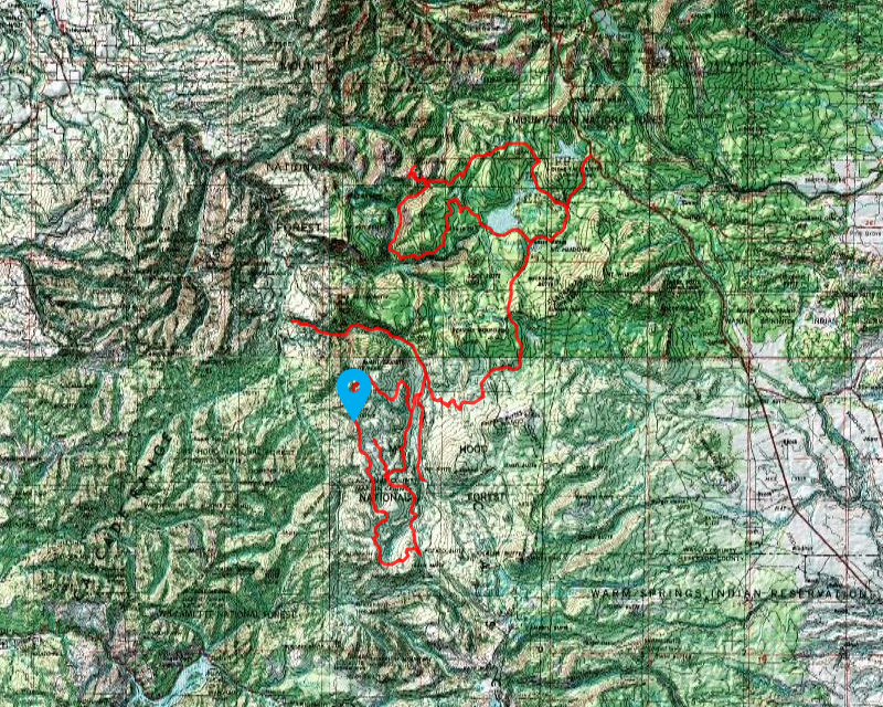
- Headed out highway 26 to where road 42 intersects it – took road 42 all the way to where it meets 46 (about 26 miles)
- Drove road 46 to the south end closure where 4690 intersects it
- Drove road 46 north to 4670 – headed up 4670 to 6350 (Graham Pass) – had lunch where the Rho Ridge trail comes close to the road
- From Graham Pass, headed south to 6355 – headed up to the south Rho Ridge Trailhead
- Continued south on 6350 to the closure gate at 46 – interesting thing was that the gate was open
- Headed back north on 6350 to Cachebox meadow and then out 4671 to 4672 and then up to the intersection on 4672 of the Rho Ridge trail – we walked down to Fadeaway Springs – it had water in it!
- Drove 4672 back to 4671 and then 4670 to 46 – headed north on 46 to the north closure point near Austin Hot springs
- Drove back down road 46 to 42 – headed up 42 to road 57 to Timothy Lake – Followed detour signs over to 58 – headed up 58 to the east end of the 4610 closure gate
- Drove out to high rock springs primitive camp – found out the east side of the road was closed due to at least one large log over the road
- Drove back out to 4610 to 58 to 42 and then back highway 26
It would have been nice to have been able to get down to the Collowash, but we ran out of time. That would have added another 20 miles to our trip, or about 30 miles if we went all the way down to where the closure would be on 63. We did a lot of driving as it was. I guess that will have to wait for another day.
We started at our usual time and headed out to Sandy, out highway 26 to Government camp and over the Blue Box pass to where Skyline Road (road 42) hits it. We headed south on 42 all the way to where it intersects road 46, which is about 26 miles if I did my calculations correct. From there we drove south on 46 to where 4690 meets it and where the south end closure gate was:

While we were looking at it, amazingly enough there was a van that came down 4690 – we think they were looking for a spot to camp. We let the dogs run around a bit and looked around, took some pictures and then headed back north. As we were driving, we came across the small burned area across road 46:

It isn’t too long, but it did burn pretty significantly. There was a sign that burned – not sure what it said, but one side of the post burned.
We continued on 46 to where 4670 intersects it and headed west. Near the 46 junction there is a spring that I never really knew about – it is on the map and is a good water source:

We headed out 4670, and at one point, there is an old access spot for the Rho Ridge trail – we stopped here and had lunch:

There were some great views to the south of Olallie Butte:

The bugs were pretty bad here so we had a quick lunch – Kirk walked north on the trail and he saw a log – I brought my chainsaw just in case we hit a log across the road, so we decided to do a little tiny bit of maintenance – here is the before shot:

And here is the after shot:

There was a smaller log just past this one that Kirk cut out as well, but this trail is really becoming overgrown and somewhat faint – at least in this section.
We finished our maintenance and looked around a bit more and continued south to Graham Pass and then continued south on 6350 to the Rho Ridge southern trailhead:

From here, we went back to 6350 and headed south to see how far we could go – we passed thru a few burned areas until we got almost to 46 where we found this gate – it was open:

We turned around (I kind of wanted to drive down 46 to see what it looked like but I resisted the urge), and headed back north to Cachebox meadow where we headed out 4671. We decided to head up to the Rho Creek trail and see what Fadeaway spring looked like.
Along the way, we turned off 4671 to 4672 and we stopped where the road crossed Berry Creek – it was an interesting little creek:

After a short stop there, we continued and finally got to our next stop at the point where the Rho Ridge trail crosses 4672. We headed down the trail to Fadeaway Spring:

Amazingly enough it had water in it. I’m not sure I’ve ever seen water in this spring. After a little looking around, we headed back up to 4672 and back down 4672 to 4671, past the lower trailhead and back to 46. From there we headed north on 46 to the closure gate at the north end of 46 – Near Austin Hot Springs:

After looking around for a bit we turned around and headed back down 46 to 42, then north to road 57 and over to Timothy Lake. From there we went across the dam and then followed several detour signs, taking 5810 to 5820 back to 5810 and then up 58 to the gate at east end of 4610:

We got out and walked down the 4610 (Abbot) road a short ways. We saw this area that had been dug out when the did the work on the road last fall for the fire – wondering if this was intended to be a turnaround spot?:

At the end of the road, there was also this piece of what appeared to be old logging equipment – wondering if it got unearthed when they were doing all this work:

We looked around a bit, enjoyed the view of Mt Hood and then packed back up and headed out. That was to be the last stop of the day. We headed out 58 to road 42 and then 42 back to highway 26 and then back home. It was a lot of driving, but I saw some things I’ve never seen before, we got to see some fire damage and even got in a little bit of trail maintenance on an abandoned trail!
We decided to stop at Fearless for dinner, which was a great way to cap off the day.