
| Date | 6/4-6/2021 |
| Location / Trail | Douglas, Plaza, Old Baldy, Eagle Creek Cutoff, Eagle Creek trails - 781, 783, 502, 504, 501 |
| Weather | Sunny to Rainy to Overcast |
| Hiking Buddies | Kirk and Zack |
| Distance / Elev | 28 miles 8200 ft elevation |
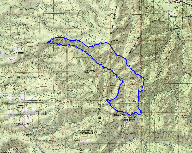
- Day 1 – Head down the Eagle Creek trail to the Douglas Trail and head down the Douglas Trail to its intersection with the Plaza trail. Go on the Plaza trail till we get to Coffman Camp (we were hoping it still existed).
- Day 2 – Continue down the Plaza trail to the old Plaza guard station and 4610. Walk a short distance down 4610 to the end of the Old Baldy trail and head down Old Baldy to the Eagle Creek Cutoff trail and head down to Eagle creek – camp at the creek.
- Day 3 – Head down the Eagle Creek trail back to our starting point.
We mostly followed the plan but day 2 was quite a bit harder than we had anticipated. More on that later.
Day 1 – Eagle Creek Trailhead to Coffman Camp – 8.75 miles
While we were driving to the Eagle Creek trailhead we encountered a dump truck which we thought rather odd, but once we got to the trailhead, we started down the road to the “new” landing (we’ve parked there before) – on the way down there was a grader – the dump truck had been dumping gravel on this road and the grader was smoothing it. We decided we should park at the top of the hill since we didn’t know what was going on. As we were getting ready, the grader came up the hill and Zack talked to the driver. It is a good thing we decided to part at the top because he said before the day was done they were going to be putting in a big pile of gravel at the top of the hill to block the road. Had we tried to park at the bottom we would have been stuck.
Due to that work, we decided to take a slightly different route to begin. We had found the that other road continued all the way up to the abandoned road that the Douglas trail drops onto, so we decided to head up that way. We went by the location of the old lookout and soon reached the Douglas Trail. From there is was pretty easy walking, uphill a lot of the way, and soon, we got to the Wildcat Quarry where we got a nice view of Old Baldy:

We saw one other hiker while we were here. It was a beautiful day and it wasn’t too warm. We rested a bit there while enjoying the view and then continued up. At this point the trail is pretty wide:

We continued up the trail and it wasn’t too long before we encountered our first real bit of snow – nothing difficult to get thru – YET:

At some point, we got a nice view of Mountains to the North (St Helens, Adams, Ranier):

Since we were doing well on time, and it is a very short side trip, we dropped our packs and headed up to the top of Wildcat Mountain. There isn’t a lot to see up there since all the trees have grown up. We didn’t spend too long up there and then came back down and re-donned our packs and continued down the trail. The Douglas trail past Wildcat Mountain gets a bit narrower and a bit brushier:

At some point we got a great picture of where we were going – Tomorrow we would be going around the head of that basin:

The trail kind of follows the ridge (more or less) and at one point there was a rocky outcropping where we got some nice views – here is Mt Hood:

And there were some pretty flowers in the rocky areas:

A little farther down the trail Zack noticed this sign – a “3” – but 3 miles from what? We all scratched our heads and even after coming home and looking at several things, I still can’t figure out what it is 3 miles from:

We continued down the trail – as we got farthe down, the trail was getting even more brushy in places:

We finally arrived at our destination for the night – Coffman Camp:

It is a pretty large, flat area but it is obvious it doesn’t get used much any longer – the ground cover was pretty healthy and the fire pit hadn’t been used in a while.
There is a sign pointing to the spring below Coffman Camp – it is a rather long trip down the hill to the spring:

We setup camp for the night, had dinner, started a fire and then went to bed. It was somewhat breezy at times but not bad. We were still hoping the weather would hold out for us.
Day 2 – Coffman Camp to Eagle Creek – 11.7 miles
We got up Saturday morning, had breakfast, got water and then packed up and headed out. We knew today was going to be a longer day, but we weren’t quite ready for how long of a day it was going to be. While we were getting packed up, it started to rain – so we had to pack up wet tents. At this point it wasn’t much rain, but it was enough to get things wet – and they would stay wet for the remainder of the weekend.
We packed up and headed out. Beyond Coffman camp, the Plaza Trail gets REALLY brushy in places – its good we all had full rain gear on because otherwise we would have been soaked:

It was starting to rain more consistently although it was still rather light – the winds had also picked up but for the most part we had been protected from them. We soon got to the junction with the Salmon Mountain trail – this goes out to the old lookout location on Salmon Mountain:

We continued along. At the point where the trail turns south, Kirk wanted to go find “Stony Camp” (it is shown on older maps) – I didn’t realize this and since I was somewhat slow due to all the uphill we were doing, I continued up. I stopped a few times and waited, thinking everyone was going to catch up but no one came. I finally dropped my pack and headed back down to see what happened. I finally found Zack who was waiting for Kirk to come back up the hill. We then continued up towards Sheepshead rock.
By this time, the rain was getting worse – it was cold, and we were intermittently getting some good winds thrown at us. It was just flat out cold. It was near this point where we saw our first significant snow – and it was tiring to get thru:

We made it thru all the snow, past Sheepshead rock, thru the wind and rain and hail (at times). We got to the point where the trail kind of levels out and it just disappeared under all the snow. At that point we just kind of headed downhill in the general direction of the trail. We got to the point where it took a hard turn, and I was thinking that had been an old road and thought it would be very recognizable – but we didn’t see it. We were able to find the old fireplace at Plaza – this was the old Guard station:

From there we started trying to follow the trail but we decided to just cut our losses and make the most direct way over to 4610. After a bit. we finally made it out to milepost 18 on the 4610 road:

And wood deck 54 on 4610 was right there – apparently they numbered each wood deck along the road – I looked at my photo from last fall at the east end of 4610 and it had a 1 on it, so the numbering appears to to east to west:

We walked up 4610 – we were all hungry and wet. We were hoping the rain would subside a bit but we didn’t have much luck with that. As we were walking we got out of some of the snow and you could see all the masticating of brush they had done on 4610 last fall – this was to be used as a secondary firebreak for the Riverside fire if needed:

We finally decided to stop at the old abandoned/decommissioned Twin Springs camp – we quickly ate some lunch under the trees trying not to get too wet. After a quick lunch, we walked down the road to the Old Baldy trailhead. We stumbled around in the snow a bit but finally found the trail and followed it. Soon we were out of the snow and following bare trail again. It was still pretty wet and windy along the trail however.
The next obstacle/challenge of the day was navigating the switchbacks up to the saddle below Squaw/Tumala Mountain. Kirk and I had been there about a month ago and turned back at about the first switchback because there was so much snow. I was hoping there would be significantly less but fearing it would still be covered. Fortunately, I was wrong – most of the snow had melted and we had a clear trail to the top except for a few small patches of snow.
We made it to the saddle pretty quickly and then headed down. The trip over to the junction with the Eagle Creek cutoff trail was pretty easy. We were now relatively protected from the wind and the rain seemed to have mostly subsided. Not having snow to navigate over helped as well. Once at the junction, Kirk checked out the car that was sitting at the access point on 4614. Zack headed off ahead of us since his knee was bothering him a bit and he was taking it slower.
Once we started down the 504, we hit a spot of snow and then a HUGE blowdown mess where we briefly lost the trail. We quickly found it and headed down – well, I mean we headed up – I had forgotten that even though this trail loses like 2000′ of elevation, it starts out GAINING elevation – you have to go back up to the ridge to follow it down – which is kind of a silly route. Once on the ridge, the trail goes up and down a bit, following the ridge. It is a pretty long slog down to Eagle Creek. When we got to the serious downhill part, I was amazed at how well the switchbacks were maintained. I likened that descent to the last bit of Corral Springs, but down there you can barely see the tread. The tread here is VERY visible and although it is steep, it is well maintained.
We finally made it down to the creek and then the search for a campsite began. Here is Eagle Creek:

Originally we were going to camp on the west side of the creek in the small campsite there, but we quickly realized that would be pretty tight for 3 tents. Zack went across the creek looking for a site but didn’t find anything too great. Kirk headed downstream and found a very old campsite that had not been used in years. The firepit was in good shape but the area had tons of small vegetation growing. We trampled it down and made camp successfully. It was a really nice site.
After dinner, Kirk and Zack were able to get a fire going even though the wood was pretty wet. The small cedar sticks and pitch wood were enough to get things dry enough to burn. Kirk and I by the campfire on Saturday night:

After not too long the fire had turned to coals and we were all tired so we all went to bed. It got dark sooner in the trees than it had the night before when it was more open.
Day 3 – Eagle Creek back to Trailhead – 7.2 miles
We got up a bit earlier this morning and made breakfast and then packed up. The goal was to be back at the truck before noon – Zack had to drive to Klamath Falls that night, so didn’t want to be driving all night long. Once we got packed up, rather than wading the creek, we found a log to cross on – Here is a picture Zack took of me crossing the log:

Once on the trail, we wasted no time – the trip was pretty uneventful and we didn’t stop too many times. Since it is mostly a gradual downhill, it was pretty easy to maintain a good pace. As we progressed, my ankle started bothering me more and more, so I had to slow down a bit.
One of the few pictures I took while we were heading out on Sunday morning – the lush rainforest of Eagle Creek:

Near where the trail heads uphill, we encountered two women hikers. They were very friendly and said they were surprised to see 6 vehicles at the trailhead. When we got to the trailhead, we were surprised to only see one other vehicle there, so I’m not sure what they were talking about. One thing I am glad is that we didn’t park at the landing on Friday because at the top of the road, there was a large pile of gravel with some VERY large stones in it. Had we parked down at the landing we probably would have been trapped.
We made it back to the truck ahead of schedule and packed up and headed out. It was quite the epic trip – very challenging, but seeing a lot of country that I’d never seen before.