
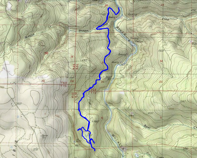
| Date | 5/15/2021 |
| Location / Trail | South Huckleberry Trail |
| Weather | Sunny and warm |
| Hiking Buddies | Zack and Thor |
| Start / End | 9:45 AM – 1:40 PM |
| Distance / Elev | 8.1 miles 1600 ft elevation |
We discussed what to do, and decided to head up a gated road – apparently it is the “Yellow Gate trail” which connected with the Huckleberry trail – these didn’t seem like trails really, they were old roads (and really not that old).
The beginning of the trip was relatively steep, especially for a road. We soon got up on more of a contour line and it mostly leveled out except for a few ups and downs. At one point, we got a good look at the burn damage across the canyon:
![]()
We continued down the road, which was in excellent shape, although not well travelled. We saw recent evidence of horses. One thing that was most amazing was how much green was on the ground under the burned areas – all the growth has occurred this spring:
![]()
We continued down the road until we got essentially to its end, where there is another loop trail around a wet area – the signs said it was the “wetlands trail”. Partway around the loop there was this cool bench that fortunately was mostly spared in the fire – you can see it burned thru in one small spot on the right side but otherwise is fully intact:
![]()
Not too long after the bench, we got to another road and then to what appears to have been a group camp area:
![]()
It had an outhouse, picnic shelter, fire ring and a big sign board, but it didn’t look like anyone had been there for a while.
We continued down the road, getting into another burned area where it looks like they had tried to make a firebreak and chipped up some logs:
![]()
Just into this burned area, the continuation of the wetlands trail headed west off this road. We decided to head down the road a bit to see what we could find. Looking across the canyon, there as this really interesting green plateau:
![]()
We also saw another picnic shelter up on a ridge – we thought that would make a good lunch spot. We weren’t sure where the road continued, but it didn’t look like anything too interesting so we turned around (after coming home it looks like the road continued back down to the main road – I kind of wish we had continued down – more explorations for another day)
We turned around and found another side road we believed to head up to that picnic shelter. This is what it looked like:
![]()
We stopped there to have lunch. It was interesting – one of the posts of the shelter was completely gone, as well as one of the benches and the top of the picnic table – but the other bench and everything else was untouched:
![]()
After we ate lunch, I pulled out my drone and took a video of the surrounding area:
After eating lunch and doing the video, we packed up and headed down – back to the wetland trail junction we had earlier seen. We headed west on that trail which obviously hasn’t seen many people recently. It was kind of interesting – but was most amazing to me was all the green in the midst of the burn:

At one point there appeared to be a side trail and we heard water so we headed over to investigate. There was a small creek running down from the cliffside that surrounded this wetlands area.
After exploring the creek a bit we headed back and were soon back where we started the loop around the wetland area. We then headed back the road/trail that we came in on. On the way in, we had seen a trail near the road and thought we’d go back that way on the way down. We made it to the junction and found what I’m pretty sure were a couple of the brown sign posts that you see – the plastic/fiberglass flexible posts – but this one was completely melted/burned:
![]()
We headed down this side trail, which basically just paralleled the road – at one point there was a big ditch and an odd looking area – we figured out it was a melted plastic culvert – it looked like volcanic rock:
![]()
We continued down the side trail but it didn’t last very long, dumping back out onto the road – we couldn’t figure out why it was even built – it was rather odd since it was so short.
The rest of the trip was pretty uneventful, just heading back down the road to where we started. On the way down, I had to take another shot of the stark contrast between the burn and the lush green underneath:
![]()
We made it back to the truck relatively early and headed home. It was an interesting day of exploring an area I’ve not explored before. One more option to have until the forest opens back up.