
| Date | 9/6/2021 |
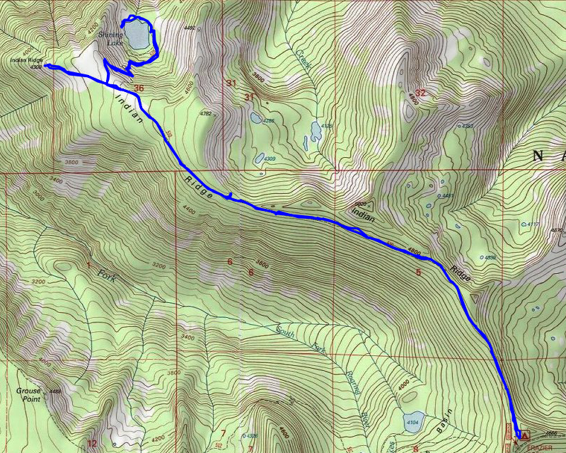
| Location / Trail | Shining Lake Trail - 510 |
| Weather | Sunny |
| Hiking Buddies | Thor |
| Start / End | 10:10 AM – 2:40 PM |
| Distance / Elev | 10.2 miles 2200 ft elevation |
Since it was going to be a long drive, I left a bit earlier than normal. We made it to the trailhead about 10:00 and I was surprised to see another car there. I remember the last time I did this trail (one of the first backpacking trips I did with my daughter), a truck had driven around the tank traps and drove all the way down to the old campsite above the lake. They have reinforced the deterrents to do this and I don’t believe anyone can drive down the road any longer. This is what the start of trail/road looks like now:

The old road is relatively flat and the areas where it gains/loses elevation are very well graded. A short ways down the trail, you get a nice view of Mt Hood from the Trail:

We continued down the road and about a mile in, we passed a group of 4 backpackers returning from the lake. I’m assuming that was who had the vehicle at the trailhead. A little farther, I was surprised to see this huge tank trap:

We continued down the road/trail making really good time. A short ways before the turnoff down to the lake, I saw this broken axle discarded on the side of the trail:

And soon we got to the old campsite at the top of hill – this is where a truck was last time we were here:

From that campsite, the trail takes off down to the lake. I was surprised at how good the tread was. I thought this trail got very little use, but maybe I’m wrong. It certainly looks like a reasonably well used trail – either way, it was in really good shape:

On the descent, we got a few tiny glimpses of the lake, but after about three quarters of a mile, we finally arrived at Shining Lake:

This was the first campsite, which is I think where we camped 16 years ago – although it looks a bit different now:

Here is the photo I took of our campsite in 2005:

We stopped here and had lunch and enjoyed the view. Thor took a short dip in the lake and did his usual sniffing around. After lunch, we decided to see if the trail continued around the lake – the map shows the trail stopping here, but it looked like it continued. We followed the trail (which got kind of indistinct at times) around the lake and found at least 2 more campsites – maybe 3 – I can’t remember. I took photos of at least two of them. Campsite #2:

And here is Campsite #3:

From that last campsite we continued until we got to the rockslide. I was wondering if maybe the trail continued across the rockslide but I don’t think so. I took this cool photo of the lake from the rockslide:

After taking that photo, we turned around and headed back up the hill. The trip up seemed a bit quicker than the trip down, but maybe that was just an illusion. We got back to the old road, and headed west toward the old lookout location. From this point on, the road got markedly worse. Some areas looked mostly like old road, and some were almost completely brushed in by rhodies.
It wasn’t too long before we reached the end of the road – the road takes a short loop at the very end which was interesting. There was a small fire ring at the end of the road and then a very short trail out to the site of the old lookout. It was easy to tell this is where the lookout was – there was glass on the ground and also you could see the mortared stones for the foundation:

The view isn’t as good as it was back when it was a lookout. but you can still see things. It was a bit smoky/hazy, but you could still see some peaks – looking southwest-ish:

After looking around a bit we turned around and headed back. On the way in, I remembered seeing a big pile of bear scat and thought “I should have taken a picture of that!” – well, on the way out I saw it again and took a photo this time – that is a pretty hefty pile of berries!:

We continued back and I cut a few small trees off the trail as we went to make passage easier – it is obvious this old road doesn’t get much in the way of maintenance – there was quite a few trees down over it. As we were walking back, at one point I noticed a rocky outcropping just above the road. I decided to head up there to see what we could see. We got to see the pretty smoky view of Mt Hood and surrounding hills:

It was an interesting diversion on the way back. The rest of the trip back was pretty uneventful – the easy road walking made for a pretty quick trip back. When we got to the truck, I noticed there was another vehicle at the campground but I didn’t see anyone so I’m not sure where they were.
We packed up and headed out – on the way out of the 240 spur I met another truck coming in and we had to pass on the road which was rather interesting.
When I was driving out road 58 a car was coming the other way flashing their lights and waving their hand out the window. It was a woman with her family looking for Little Crater Lake. I had gone there a few years ago just to see what it was, but couldn’t remember exactly where it was. I pulled out my maps and figured out she had taken a wrong turn. She went left instead of right. So I think I got her straightened out and she was very thankful. The only other thing of note was the traffic on the way home – 26 was REALLY busy. At times traffic came to complete halt. When we got to Zigzag where 26 turns back to 4 lanes things cleared up but it was a pretty slow trip until then.
A great day in the woods rediscovering a very interesting trail and location.