
| Date | 9/14-9/16/2021 |
| Location / Trail | Olympic National Park |
| Weather | Sunny to rainy |
| Hiking Buddies | Carly |
| Distance / Elev | 18.1 miles 4100 ft elevation |
Due to lots of activity and general life busyness, we decided to do a less strenuous trip this year. Carly nicknamed it a “chill” trip, which was reasonably accurate. While it was reasonably easy, especially compared to some trips we did, it did have several surprises and enough challenge.
This was the plan:
- Day 1 – Drive to the Olympics, get our permits, etc situated and stage the cars for the shuttle
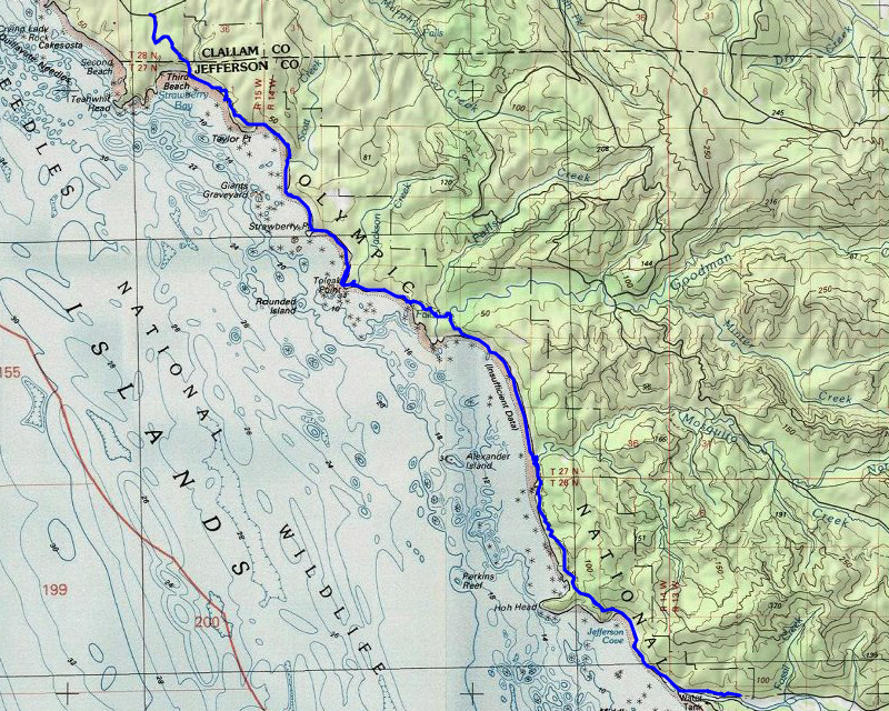
- Day 2 – Third Beach to Toleak Point – 6.8 Miles
- Day 3 – Toleak Point to Mosquito Creek – 5.5 Miles
- Day 4 – Mosquito Creek to Oil City Trailhead and then drive home – 5.9 Miles
Total Mileage: 18.2
Monday – 9/13/2021
This was a day of driving and getting things setup for the trip. We decided to meet in Port Angeles and then decide on what to do from there. It is about a 5 hour drive from home for both of us so it seemed a good place to meet. We met around 1:00 and then had lunch at a restaurant on the water. After a leisurely lunch (this was a “chill” trip), we drove down to the southern trailhead to leave my truck there for the shuttle. I was surprised to see quite a few vehicles at that trailhead since it was a Monday – but Carly thought maybe people were doing a long weekend. I unloaded my gear into Carly’s car and then we drove back to the campground (Bogachiel State Park) where we had a reservation for the night. After setting up camp, we drove into Forks (a small town – the only one nearby) and had pizza for dinner and then came back to the campground and went to bed since it was getting dark.
Tuesday – 9/14/2021 – 6.8 Miles
We woke up Tuesday morning, broke camp and then headed out to the northern trailhead. It was kind of a foggy day to begin with and I had seen that there was supposed to be rain (which I wasn’t looking forward to) I think we ended up starting out about 9:45. There were quite a few cars at the trailhead, even though it was a Tuesday. I later found out that many people just hike to the beach and back – they aren’t doing the whole loop like we did. This part of the trail is REALLY wide – like a road:

It wasn’t too long before we got our first look at the ocean – this was “Third beach” (there is a first and second beach farther north):

This was our first beach leg – the trail alternates between beach segments and headland segments where you have to go around spots there is no beach. The interesting thing is that there isn’t much of a trail from the beach to the headlands – you basically just go straight uphill for the most part. The good news is that these areas do have some assistance in the form of ropes and/or steps to help.
We started down the beach – at this point it was just kind of foggy – no real rain, just a slight mist from the fog:

Very quickly we came across this beach art – one thing we were amazed by was the amount of ocean garbage that washes ashore – I don’t think they have real beach cleanups here and there is literally tons of garbage that washes ashore – people have gotten creative in how they utilize it:

It wasn’t too long before we had to climb up to the headlands to continue. This was our first experience with climbing to the headlands – it is steeper than it looks – this was climbing up to the Taylor trail segment:

Here is another example – a “ladder” (which has some missing rungs):

The climb up is not too far, and not that difficult but it is rather short and intense. Once in the woods, the trails were in good shape for the most part, but I was surprised at how muddy they were:

You do get some great views from the headlands:

And this segment of coast has lots of interesting rocks offshore:

A bit farther along the Taylor trail, we came across this huge pile of ocean garbage – I don’t know if people collect it and just dump it here or if they take it out with some frequency or what – but it was a LOT of garbage, all apparently washed up from the ocean:

This trail segment wasn’t too long in the woods and then we dropped back down to the beach where it got a bit rocky:

At some point in this area Carly found a fully inflated soccer ball. It had started raining a bit and we started kicking the soccer ball down the beach. It kind of helped to keep our minds of the rain (and the wind in our faces). Since the weather had gotten increasingly tougher, I didn’t take a lot of photos for a while. We just kicked the ball down the beach, retrieving it from the ocean when it rolled into the waves.
Since this was a relatively short day, I think we got to our planned spot around 2:00 and started looking for a campsite for the night. There were a couple that were occupied but there were quite a few available. We found a nice one and setup camp. The campsite was in the trees and it helped cut down how wet we had gotten. After we got setup I think we both kind of chilled in our tents for a while.
After a while of hanging out, we decided to go find water – it was a bit of a hike, having to go all the way around Toleak Point (with its accompanying wind) to the outlet of a small creek. We filled up and while I was looking at my map it showed a shelter in that vicinity. We looked around and didn’t see anything and then I looked up and saw the shelter – it was a bit above the creek. We climbed/clawed our way up the hill and took a look. It was in pretty poor shape but was an interesting artifact:

We went back to camp and made dinner and went to be early. This is what our campsite for night 1 looked like:

Wednesday – 9/15/2021 – 5.5 Miles
It rained during the night but at some point things cleared up and the view on Wednesday morning was much nicer:

We got up – it was a bit chilly but not too windy. We made breakfast but kind of lazed around camp for a while. This was the day (we thought) we had to pay attention to the tides and hike at low tide, so we were not in a hurry to leave. I think we left camp around 10:20 or so – normally we are usually gone by 8:00 or so.
We continued south, around Toleak Point and the weather was so much nicer today – a little windy but dry and sunny:

We didn’t hike too far on the beach and then had to head up on the Goodman trail. Once up on top this was looking north from where we came:

Partway down the trail we came across this really interesting root – I don’t think I’ve ever seen a root like this:

And shortly after that strange root, we came across this “Candelabra Tree”:

About halfway on the Goodman trail, we came to a creek crossing and a small waterfall on a tributary of Goodman creek:

A bit farther we crossed Goodman Creek proper which looked pretty low:

One thing I noticed on this segment of trail was the absolutely beautiful, huge trees:

After crossing the creek we soon made our (rapid) descent back to the beach. This is what the beach looked like after coming down from Goodman Creek:

At this point we had a clear shot all long a reasonably easy beach segment to get to Mosquito creek. That was our destination for the night.
This is what Mosquito Creek looked like – more of a small pond than a creek:

We headed over Mosquito creek and back up into the trees since we didn’t really see any campsites. Once up the hill a little ways we found several campsites as well as the toilet and we decided on a campsite for the night. One thing I forgot to mention – other than the people camped at Toleak Point, we only saw two people all day – two guys coming north. They said they were alone at Mosquito creek the night before, and we were also the only ones camped there the night we were there.
This is what our campsite Wednesday night looked like:

Close by our campsite there was this tree with these very weird bumps on it – I wonder what causes those?:

After setting up camp and relaxing for a while we made dinner and then went up to a viewpoint where someone had built a little bench where you could watch the sunset. We watched the sunset, and although it wasn’t a spectacular one, it was really nice to be in this beautiful setting watching the sun go down:

After the sun set, we went back to camp and went to bed.
Thursday – 9/16/2021 – 5.9 Miles
Thursday was our last day on this trip and usually the last days are not too exciting – it is mostly about getting off the trail and getting back home. This day had a few surprises for us however.
The plan was to get going early so we could get out and get lunch in Forks and then head home – we both had 5+ hour drives ahead of us. We got up, ate breakfast and got all cleaned up and packed up and headed up by about 8:00. We only had less than 6 miles and we thought we’d easily be back to the truck by noon – you know what they say about plans….
We continued on the Hoh Head trail which had some gorgeous huge trees on it:

This segment of the trail also had some interesting boardwalks – other segments had something kind of similar but these seemed better built (or maybe they were just newer):

We also passed this HUGE uprooted tree:

And had to navigate this interesting carved staircase:

This segment of woods walking was one of the longest of the trip – these were typically harder to do because the trail was muddy, there were lots of roots to avoid and lots of up and downs – not too much clear sailing. It took us about 2 hours to navigate these 3 miles thru the woods and we thought we were home free. This segment had one of the more difficult descents:

We finally made it to the beach and it was just about high tide but we didn’t think that mattered too much. We figured worst case we’d have to wait a few minutes. We were wrong.
As we were walking down the beach we saw these prints in the sand:

After looking at them I think it might have been a fox – it certainly looked like a canine and since dogs are prohibited from the park, a fox seems like a likely probability.
At one point I looked back at Hoh Head where we had come from:

It was shortly after I took this photo that things changed quite dramatically. There is a rock outcropping just north of diamond rock that is covered at high tide. There is no beach, just large rocks. We made our way partway around the corner but got stuck. We stopped and waited for a while and the water receded enough that we could pass if we timed it correctly. We got around the corner to another spot that was the same, so we had to wait some more. While we were waiting, I was watching the waves, trying to figure out how to time them correctly. While I was looking, I saw something with a fin pop up in the water. After looking at things post hike, I think this was a harbor porpoise:

After 3 hours of waiting (about half way to low tide) this was the area we needed to get by:

The water had gotten low enough and it looked like it was just a short segment that we needed to get thru – worse case was we’d get wet feet. We tried and Carly got both feet wet and I got one foot wet, but we finally made it thru. We thought we were home free but we found out we still had more obstacles – at least these were passable:

We had to walk over rocks of various sizes almost the whole way back but at least we weren’t stopped by the tide anymore. When we finally got to the spot where the Hoh River dumps into the ocean we found literally THOUSANDS of birds (they are really hard to see in the photo – it just amazed me how many birds were there):

We kept walking and followed the river and found the trail back into the woods. As we were walking, the trail basically followed the river and I saw these interesting rock formations in the river:

We kept walking and finally made it to the truck about 3:00! Had we not had to wait 3 hours for the tides we would have been able to get back around noon as we were planning.
Since we hadn’t really planned food for lunch on Thursday, we wanted to have a “goodbye” lunch – it ended up being more of “linner” (lunch and dinner). We stopped at a local place, had a nice meal, and then continued north to go get Carly’s car. By the time we got there, it was almost 5:00. I changed into my driving clothes and we said goodbye. She headed north on 101 and I headed south. I got home about 10:00 after stopping only once for gas. I think Carly got home a little later than I did.
It was an amazing trip that had a great mix of being laid back while also throwing in some unexpected experiences. It was cool we didn’t see anyone the last two days except the two guys going north – we saw not one person on Thursday at all! It is definitely a trip I’d do again.