
| Date | 10/9/2021 |
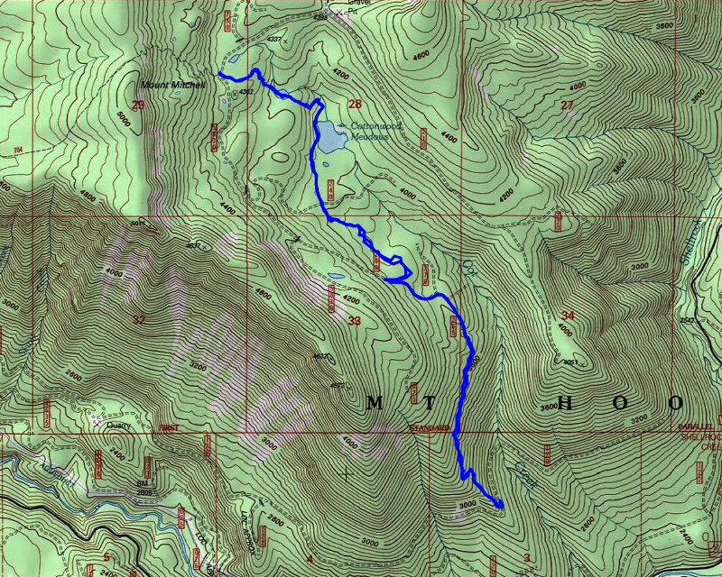
| Location / Trail | Cottonwood Meadows Trail - 705 |
| Weather | Overcast to sunny - cool |
| Hiking Buddies | Thor |
| Start / End | 10:35 AM – 3:45 PM |
| Distance / Elev | 7 miles 1900 ft elevation |
We headed out about our normal time and got to the trailhead about 10:30. On the way in we passed a LOT of what I’m pretty sure were hunters camped along road 58. We passed a few vehicles, even up 5830. There was one car at the Shellrock lake trailhead when we passed and we even encountered one truck past that trailhead – almost to the Cottonwood meadows trailhead. It was kind of weird – I’m not used to seeing so many people up in the woods so late in the year.
We packed up and headed out. As usual, Thor was raring to go. We started down the trail and were quickly presented with lots of nice fall colors:

It wasn’t too long before we got to the first meadow, which was completely dry:

A few things that were different that I remember from my last trip (2 years ago):
- The flags marking the entry and exit to the meadow seemed gone – I really need to make sure I have flagging in my pack to help with stuff like this. I think I’ve used all my flagging up.
- The trail generally was in rougher shape than I remember – mostly due to downed trees
- I always seem to forget how much elevation you gain/lose on this trail – I think it is pretty flat due to the meadows, but you go down to each meadow and then down to the spur road on the south end.
We found our way across the first meadow, found where the trail re-enters the woods and continued down. We soon got to the second “meadow, which is more of a lake. It seems to hold water pretty much all year long. Although the map doesn’t show a name, I call it Cot Lake since this feeds Cot Creek:

We made our way around the lake and continued to the third meadow which gives you a good look back north at Mt Mitchell. I played with the zoom on my phone and I’m pretty sure this is a (blurry) shot of the overlook above off the Rimrock trail:

Thor was have a good time running around in the meadow. After a bit of looking around, we continued down and soon hit the 240 spur. From here, there is really no trail – it is in an old cut area and the trail was never maintained thru it. The good news is that for the most part it isn’t too bad to walk thru. The cut is not recovering well at all and there is a lot of open space that makes walking thru it relatively easy. We made our way thru it – I think I finally found the “wash” that Donovan refers to. It appears to be a runoff “creek” that runs down the east side of the cut along the cut line. For the most part, that is relatively easy walking but there were a few rough spots. It seems like I never take the same route twice thru there. I end in the same spots in a few places but get there differently every time. I guess that is part of the adventure.
As we headed thru the cut, we came to an old skid road. The trees in this area were getting a bit tougher to get thru, so we headed up the skid road to where it meets the 260 spur and then walked down the 260 spur. On the way down the 260 spur, I saw a lot of large hoof prints. At first I thought they were from a horse, but I think they were from a large elk – some of the prints (although they weren’t fresh, they were reasonably easy to see), had a line down the middle which would indicate deer or elk hooves, not a horse:

If that was indeed an elk print, it was a VERY large elk!
When we got to the junction with the 270 spur we stopped to have lunch. After eating, I took out my drone and got some interesting video from a higher vantage point:
After putting away the drone, we continued down the road to the end and started down the lower segment of the trail. This segment is significantly rougher than I remember. The vine maple and rhodies have REALLY grown up in some areas, obscuring the tread. I didn’t bring my loppers, but I did spend a fair amount of time cutting out a few sections – one spot had a tree right in the tread, making it almost impossible to get thru. After you get back into the real old growth again it gets better, but the transition from the cut to the old growth needs some attention for sure.
Once back into the woods the trail gets better, however there were quite a few logs down. I cut the smaller stuff out but this too could use some attention. I counted approximately 25 logs (some pretty large) in the last quarter to third mile above the 4635-120 spur.
We made it down to the 4635-120 spur and found it pretty rough – no traffic here for quite some time since 4635 has been closed for over a year now:

We didn’t spend too much time here – mostly just turned around and headed back uphill. As we were going up, I took a photo of probably the largest downed logs in this lower section:

I didn’t really spend any time on the way back up doing any maintenance as we needed to get back to the truck. As we headed back up the hill, the sun actually came out! The wind kind of picked up a bit too – I think the forecast rain was blowing in. We made it back up the lower segment in about 45 minutes and then did the cross country section in another half hour or so. When we got back to the 240 spur crossing, we headed across the road back on the real trail (even though it is still kind of rough). When we were getting to the north end of that south meadow, Thor took off, bouncing thru the meadow (he looked kind of like Tigger bouncing thru the meadow) – I thought he saw an animal, but as I got closer there were 3 hunters standing in the entry to the meadow. I called him and he finally came – I put his leash on and when we got to the hunters I told them I hadn’t expected to see anyone and they replied they weren’t expecting to see a dog either. They asked if they were on the Cottonwood Meadows trail and I told them they were, but it doesn’t get much traffic so it can be kind of faint. We didn’t talk long and we continued our trip north. We made good time, getting back to the truck about 2 hours from the bottom end. We packed up and headed out.
As we were driving out the 5830 road, I saw these beautiful fall colors across the canyon and had to stop to get a photo:

Shortly before 5830 meets 58, got behind two trucks who were going VERY slowly (like 15 miles an hour). The first one kind of sped up and disappeared but the one in front of me just putted along – I had to follow him for several miles until he finally turned off on a spur road. It was pretty frustrating that someone was not considerate enough to let me pass – that is just kind of common forest road courtesy.
Once past the slowpoke, it was the typical long ride back home over Mt Hood. It was a beautiful fall day with amazing hiking weather. A great day out in the woods.
I think we need to put this trail on the “todo” list to clean up some of the rougher spots…..