
| Date | 10/30/2021 |
| Location / Trail | Sisi Butte and Skyline Trail |
| Weather | Mostly sunnny but windy and cold |
| Hiking Buddies | Kirk, Ollie and Thor |
| Start / End | 11:00 AM – 4:00 PM |
| Distance / Elev | 7.3 miles 1800 ft elevation |

We passed the new bridge over Last creek which is really nice – much better than the old wood one that was here:

Here is what the old wood one looked like:

Once we explored those two things, we headed back to 4220 and headed down to Olallie Lake resort. We weren’t sure if the gate would still be open or no but we thought we’d try. We were fortunate and found the gate near 4690 open and we encountered a few vehicles on our way in, so there was more traffic than we were expecting. We made it to the lake and found the closure gate on 4220 just past the old ranger quarters:

We walked around the day use area and down to the boat ramp – the lake was pretty choppy as the wind was pretty fierce here – the wind made it VERY cold:

After looking at the lake we headed past the store and down to the Paul Dennis campground. After looking around a bit to see the fire damage, we headed back – on the way, we saw someone was staying in one of the cabins and it appeared as though a couple people were working on something up the hill. We wondered if it was the owners taking advantage of a nice weekend to get some maintenance done before the winter. We headed back north on 4220.
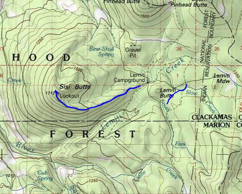
It wasn’t too long before we got to the 120 spur that heads up to the top of Sisi butte. It is gated so we parked at the gate and headed up. We weren’t sure how bad the wind was going to be, but we were pretty prepared. This is what the beginning of the road leading up to Sisi looked like:

The trip up the road was relatively quick. It wasn’t too bad elevation wise even though we gained over 1200′. The road is about 3 miles to the lookout.
We rounded the last corner and soon saw the Sisi Lookout:

We looked around the area – there was a lot of stuff up there -propane tanks, two small buildings – one for communications/radio equipment it looked like and another one maybe for a fuel cell or generator or something. Up near the lookout, there was a radio repeater just like the one at Squaw Mountain, and there was also an outhouse.
We headed up the stairs up the lookout but every new flight of stairs made the wind stronger. As we ascended, the steps and handrail had frost on them. We couldn’t get all the way to the top platform, as they have a trap door that is locked, but we made it just below that. I couldn’t get Thor to come up more than 3 stair flights so I went up and left him down (where he complained VERY loudly). It was so cold up there I don’t think a spent more than a minute or two up there. I took a short video and a panoramic photo and then quickly headed down. Kirk and Ollie stayed up there for a few minutes – I don’t know how they did that – it was BITTERLY cold up there.
Here is the 360 Photo
And here is the video:
After looking around the lookout, we searched for a quieter place to eat lunch. We found a somewhat sheltered area on the west side of the butte, down below the road. We ate lunch and then went down into the woods to see if we could find any remnants of a trail Don said he found several years ago. After searching quite a bit, neither of us found anything resembling any real trail – no blazes and no definitive tread. After searching, we decided to head back down.
The trip down was relatively uneventful, but we did encounter a few surprises along the way. We got a great view of Mt Jefferson from the road:

And a little farther down the road got a good view of Olallie as well:

A little farther down eagle eyed Kirk saw this interesting water catchment thingy – our theory is that this was built to capture rainwater and save it for animals to drink:

As we got closer to the bottom, there were some rather large trees:

And Kirk also found this old blaze along the road:

After getting back to the truck, it was just a little after 2:00 so we decided to explore a nearby section of the old Skyline Trail. There was an old road on the map that showed the trail went near it so we headed over to that road. Once we got there the route of the road was either wrong on the map or it got all messed up by all the cutting/thinning that was being done in this area. I’m not sure what the purpose was, but I’m guessing maybe it was to try and stop the heavy beetle kill in the area. This is what the “thinned” area looked like near where the trail got obliterated due to all this work:

We drove along some “wood chip roads” which were pretty muddy in places:

When we got close to where the trail was supposed to cross it, we encountered a pretty large hunters camp with probably 4 or 5 vehicles, an RV, a big wall tent and a woodstove going. They were setup for some comfortable long term camping….
Anyway, we set out and attempted to find the tread in this huge cut area – we were successful in finding small portions of the tread in the cut area, and a couple of random flags, but mostly the old tread had been obliterated by all the cutting and wood chips being spread. Once we got to the edge of the cut area, we located the tread again and followed it for a ways. The track I had ended but we kept following it and believe this was where the trail crossed Slow Creek:

We continued north and soon lost the tread near an old road (possibly the 130 spur). We turned around and headed back – along the way we found quite a few old blazes, and even one triple blaze.
When we got back to the cut area, I thought we were done, but Kirk continued poking around and found the trail on the south side of the cut – we ended up following the tread for a while on the south side of the cut but it was getting late so after about a third of a mile or so we turned around and headed back. The trail where we turned around was in pretty good shape – I’m pretty sure we could follow it down to the next segment south.
We got back to the truck, headed out and started the long drive home over the mountain. We stopped at Fearless for a burger and a beer which was a great way to end an awesome day of exploration.