
| Date | 1/1/2022 |
| Location / Trail | Highland Butte |
| Weather | Sunny and cold |
| Hiking Buddies | Kirk, Ollie and Thor |
| Start / End | 9:40 AM – 12:30 PM |
| Distance / Elev | 3 miles 850 ft elevation |
Kirk had to get back for something in the early afternoon, so this worked out really well. It wasn’t a long hike but it was really interesting and an area I’d like to go back to again. It is pretty handy, only being about 15 minutes from home.
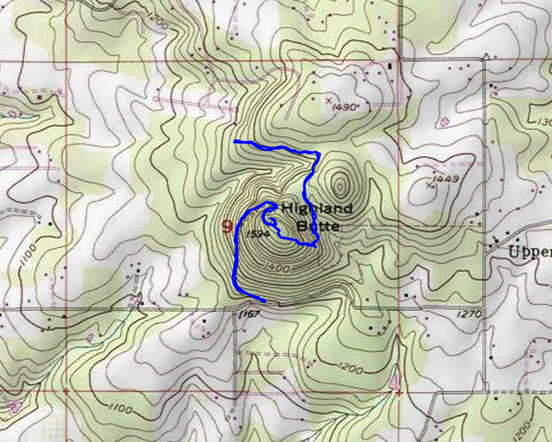
We made it to the bottom of the gated road up to the top of Highland Butte. We got ready and headed up the road. We saw footprints from probably the day before but they didn’t go too far up the road. Mostly we were the only ones that had been up there. The road gets a bit steep in places but is only about a half mile to the top where there is a cell tower:

We looked around a bit and I attempted to fly my drone – it was a PERFECT day for it – clear with no wind – but I found out that the app that controls the drone broke with a recent update – since I had cell service I attempted to fix it up there but had no luck, so I put away the drone for the day – too bad because I think I could have captured some really good footage from above the trees.
I thought we would be able to see something from the top, but it is all treed in (the tower extends above the trees). Maybe another day.
Once the drone was done, we decided to head down a side trail that Kirk found – it headed kind of downhill to the southeast, so we thought we’d see where it goes. We didn’t really want to go on anyone else’s land (since this is surrounded by private land), so we tried to be careful to stay on the BLM property. We headed downhill and soon came to a really cool viewpoint to the east, where got a glimpse of Mt Hood Thru the trees:

We looked around a while – we thought we saw the new radio tower on Whalehead but it was a long ways away. After looking at the viewpoint for a few minutes we continued on the path – it took a turn to the north and we found a couple of short side trails, but they all appeared to head onto private property. The trail was relatively flat in this area – it soon took a westerly turn and kind of followed a fenceline of property to the north. At the last of these properties, the trail kind of stopped – I think this trail is basically an access point for these various landowners to access the BLM land.
When we got to the end of the trail, we decided to turn around and head back. We weaved our way back up the trail to the top. By that time, it was close to lunch time, so we stopped and had some lunch next to the cell tower. I caught some pictures of Thor playing in the snow (the dogs were having a great time in the snow):

After lunch, we headed back down the hill and pretty quickly got to the truck. We found what might be a trail that hit the road down lower, but that will be for another day of exploring.
A great way to start 2022!