
| Date | 7/13/2013 |
| Location / Trail | Huxley Lake Trail (and vicinty) - 521 |
| Weather | Sunny |
| Hiking Buddies | Kirk and Bandit (Kirks dog) |
| Start / End | 10:15 AM – 6:00 PM |
| Distance / Elev | 11.1 miles |
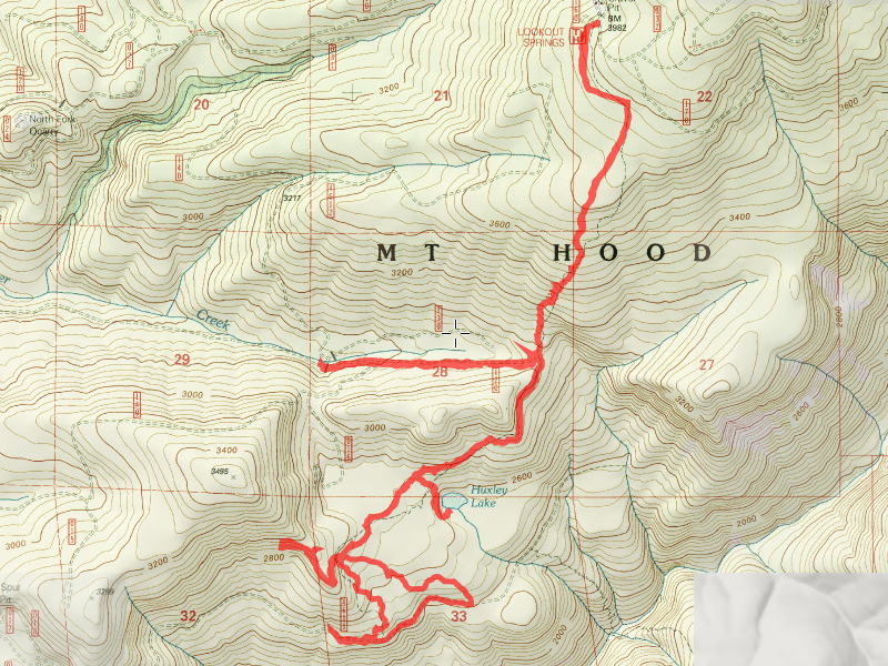
We started out at Lookout Springs about 10:00, and headed down the trail to Huxley Lake, passing the old corral (which I assume is what Corral springs was named for). At the junction, we started our steep downhill down to the lake. The trail is pretty steep (I should have gotten a few photos of it) due to it being abused by ATVs over the years. We believe we found remnants of the original trail that switchbacked down the hill a lot more than the existing trail does. The existing trail just heads straight downhill in a lot of places. After enduring what seemed an endless series of steep downhill sections of trail, we finally came to the old road described in the trail guide. The trail to the lake takes off to the left, however we kept walking down the old road – I was trying to remember where I had gone the first time I hiked the trail. We made it all the way out to the 4612 road, which now has a huge “tank trap” on it to keep people off the old road. Once we found the old road, we headed back to the Huxley Lake side trail, which we followed down to the lake.
Here was our first view of Huxley Lake:

We looked around a bit and had lunch at the lake. One interesting thing – there was a fire at the lake, and it appears as though it was caused by the campfire. It looks like a “root fire” that smoldered underground and killed several of the trees, which subsequently fell over into the lake.
Here are some of the trees – they were kind of stacked like lincoln logs on top of each other:

Here is a nice panorama shot of Huxley Lake:

It is a small and shallow lake, but it is pretty. I remember the last time I was there, there was a lot of damage from ATV riders around the lake. It appears as though some of that damage has been reduced over time, but you can still see the scars left by the ATV riders.
After eating lunch and investigating the burned area for a while, we decided to head back up to the trail and take it all the way down to the 4611 road. (so we could get a complete track of the trail). We headed back up to the trail, until we got to a strange intersection – we opted to go downhill, which was the right decision. After a while, we ended up at the 4611 road. The map showed the “real” Huxley Lake trail starting up the 4611 road a ways, so we walked up the road thinking maybe we had followed an ATV trail instead of the real Huxley Lake trail. After walking up the road a ways past where the map showed the trail, we decided the map must be wrong – but on the way back, we decided to go cross country to see if we could see any other trail. We were unsuccessful, however we did see this interesting marsh/meadow area:

We ended up right at the junction of the two trails. Just to see where it went, we decided to go back up the other trail. We were thinking this was the “real” Huxley Lake trail – all we had to do was to read the description on Trailadvocate.org and we would have known what this trail was:
If you start at the 4611 end, keep right at the first trail junction about a half mile up the trail. The route to the left is an old trail which leads back towards Winslow Pit. You can come in from this direction on this unofficial trail (a re-use of a segment of an old trail) if you like. It starts on the left at the crest just before the end of the 4611-136 spur in a recently harvested area, about a mile off the 4611 road before Winslow Pit. The 4611 road gets rough beyond Winslow Pit. The alternate access is good road but will add a mile and a quarter to your hike.
We walked a ways until we realized the trail was not going in the correct direction – after a bit of discussion and a brief attempt at off trail cross country travel, we decided to turn around and head back up the trail (back the way we came). We needed to water up before our big ascent back up the hill, so we stopped at this pretty little creek crossing and filled up:

After filling up, we headed on our way, doing some trail maintenance as we headed up the hill (cut a couple of logs, did a lot of brushing of the trail, and kicked branches and rocks off the trail). After what seemed an eternity of steep uphills, (similar to the downhill section), we finally ended up on top. We made it back to the truck without incident – a little tired, but having a great day in the woods.
We stopped at Fearless for burgers (we were both hungry!) – a great way to end the day!