
| Date | 7/27/2013 |
| Location / Trail | Surprise Lake |
| Weather | Sunny and warm |
| Hiking Buddies | Kirk |
| Start / End | 9:55 AM – 6:20 PM |
| Distance / Elev | 7 miles |
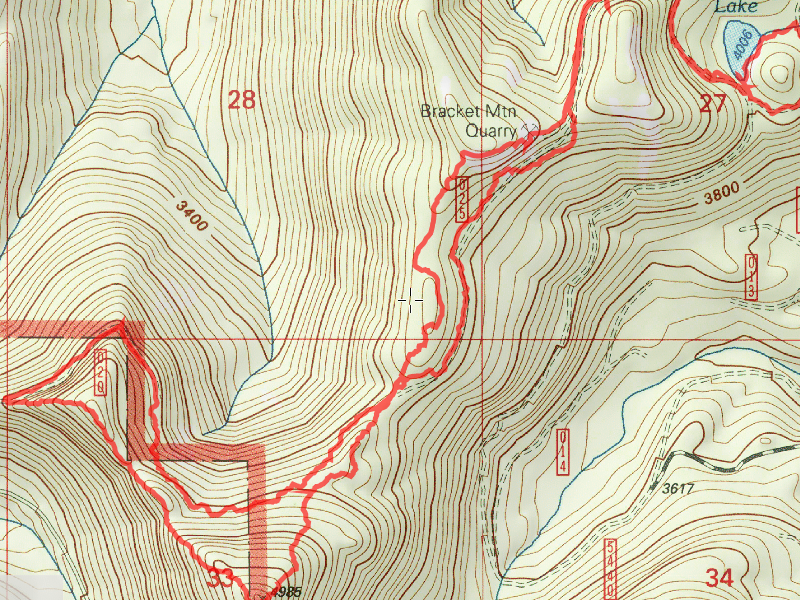
The plan was to drive out to the end of the road, then take the decommissioned road to the end – from there, the idea was to hike on the same contour line (same elevation) until we got to the decommissioned road on the other side. According to the map, that distance was only about 3/4 mile. Reality on the ground proved to be much different.
We drove to the end of road 4540-020 spur (or 54-020, not sure which it is – it is the 020 spur road). That road looks to have been closed by rockslides before where it shows the end of the road on the map. After the rockslides, the road was decommissioned and pretty heavily treed with young alders (like most of the roads up Fish Creek). We trudged through, hoping the alders would thin out a bit, which they did (sort of) for a bit. We got our first view up the canyon at the corner on the road:

That was just a taste of the views we would see today. Here is a picture of a “good” place in the old road:

Continuing up the road, it shortly disintegrated and then we were left to cross country travel. The road stopped before it showed on the map, so we would be doing more cross country travel than expected. Little did we know it would end up being a LOT more than expected before the end of the day was over. As we headed cross country, trying to stay on the same contour as we left, we ended up having to head uphill to try and avoid thicket after thicket of Devils Club. We ended up quite a bit higher than we wanted to be, so when we started getting close to where the other road was supposed to be, we headed downhill. We looked and looked and found no road, but we continued in the general direction of where the road was supposed to be. We finally found a corridor that had been cut, but a roadbed had never been made. So, it was covered in vine maple and other assorted brush. We fought our way through this for a bit, and decided to head back into the woods, where the undergrowth (at this point) was much less. After a bit, we came to the LARGEST thicket of Vine Maple I’ve ever seen in my life. I swear it went on for at least a tenth of a mile (although probably not that far). It went up, down and across the hill, making travel almost impossible. We then headed downhill, until we finally got through the vine maple thicket. We continued below this old corridor for a while. The map shows an old quarry, so we surmised that there must have been a road to the quarry, so we headed back uphill (a long ways up a very steep hill) to try and find the road. Fortunately, we were able to find the road at this point, and we started making pretty good time, since the road wasn’t too bad. It was getting overgrown with young trees, but it was reasonably easy to navigate through them. After a short bit of hiking on this road, we came to a turn, and were presented with this view up the Cedar Creek drainage:

Interestingly enough, we also had a reasonably good cell signal here. Here is a nice panorama of the view from this spot:

After resting a bit and watering up, we continued down the old road and quickly arrived at Surprise Lake:

We poked around the lake a bit and Brian (who wasn’t able to accompany us) wanted us to explore the outlet of the lake, looking for a waterfall. We headed to the outlet and followed it to the road east of the lake. We followed it past the road a bit, but it was very brushy. Knowing we had a lot more bushwhacking to do, we opted to turn around and start back to our rig. Since we had such bad luck on the way there, we decided we would try and stay high, on the ridges, and maybe avoid the worst of the Devil’s Club and Vine Maple (they like water and the hope was that there wouldn’t be a lot of water on the ridge). So, off we went. And we climbed. We mostly missed the heavy brush we encountered on the way in, but we did a lot of climbing. We got to the site of the old quarry and found a nice viewpoint:

We enjoyed the view and continued on our way. And we climbed. And we climbed. Part way up to the top of Bracket Mountain, we got this really nice view of Mt Hood:

And we continued to climb. For what seemed an eternity up a REALLY steep hillside. I’m not sure you could really call what we were doing hiking – it was climbing more than hiking. We FINALLY got to the top of Bracket Mountain (5013 feet if you believe the benchmark placed there in 1913):

And we got quite the panoramic view:

Here you can see Kirk checking out the benchmark – this was the peak of the mountain:

Looking down from the top, you could see some very interesting rock formations:

And a nice “kind of” meadow – at least the wildflowers seemed to like it:

Once we enjoyed the views for a bit, we decided on a route back to our rig. We decided to continue along the ridgeline, to keep out of the brush. This plan worked pretty well. Until the very end of our hike. On the map, it looked like the ridge went down pretty easily back to the road. What we found was pretty steep. A couple of times we thought we might have to turn around, but very carefully and slowly we managed to work our way across rock faces and down a pretty steep hillside. We ended up about 20 feet from our rig!
A few lessons learned from this trip:
- Nothing in the Fish Creek Drainage is as simple as it looks on the map.
- Don’t ever wear shorts when planning to go cross country.
- Going cross country always takes longer than you think it will.
- Fish Creek country is beautiful – but you have to earn it.
- You never know when you will find a geocache (we found 2 of them!) even when you aren’t looking for one.
We ended up getting back to the rig at about 6:30pm – about 4 hours later than planned. Since I was a bachelor all weekend, I had planned on hiking the Rimrock trail (a relatively easy task) on Sunday – but after this trek, I was too wiped out. I ended up staying home to recover. This was a fantastic (albeit very difficult) adventure on a fantastic day. The visibility was great, and even though it was exhausting, it was a bunch of fun.