
| Date | 8/2/2013 |
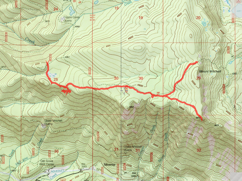
| Location / Trail | Rimrock and MP3 Trails - 704 |
| Weather | Cool and Overcast (we hiked in the clouds most of the day) |
| Hiking Buddies | Bodie (my dog) |
| Start / End | 10:50 AM – 4:00 PM |
| Distance / Elev | 7.5 miles |
We started off in the morning, and it was pretty cool – especially for an August morning. I almost put a jacket on when I started, but figured I would warm up soon enough-which I did. I had high hopes that the clouds/fog/mist would burn off, but that did not happen to any great extent. We did have a few moments later in the day when the sun came out for a few brief moments, but most of the day was in the clouds and fog. That was OK – it was still a great day.
This gives you a sense of what it was like hiking in the fog:

On the way up, I had wanted to see if I could find the junction with the MP3 trail. I remember the last time I was there, I saw some flagging, and thought that might be the junction. Although I didn’t see any trail at the flagging, I followed it a bit to an interesting little seasonal stream (or at least that is what it looked like):

We explored that a bit, and quickly realized that was not the junction. We continued on our way to the overlook trail. When we got there, this was our view for the day:

Not much of a view. Even the “point” which normally is an exceptional view of the valley was completely socked in:

We didn’t even venture out to it. We stayed on the main landing (near the old helicopter landing pad) and ate lunch and enjoyed the spot. After eating lunch and watering up a bit, we headed back down the trail. One thing I noticed while hiking down was how wide the trail corridor was. It is getting somewhat overgrown, but where it goes through the trees, you can see a very wide corridor. I’m thinking this must have been a pretty major re-supply route for the lookouts. I could just imagine a long pack trail of horses/mules with supplies headed down this trail:

After getting back to the junction with Rimrock, we continued up the trail to the point where it starts its short descent to road 5830 and the Cottonwood meadows trail. Normally, you get a pretty good view here, but not today:

There is a cool rock field on this end of the trail, though:

We (I) didn’t really want to do the descent to the 5830 road, since we would just have to turn around and come back up, so we turned around at this point and headed back. I had some time (a little), so I decided to look for that junction with the MP3 trail. After reviewing the trail info sheet, I realized the junction was near the start of the trail, right after the first overlook viewpoint. So, I carefully looked to the south for any evidence of a trail junction. While I was thinking, I remembered seeing a 704 sign on a tree – I thought that was an odd place for a trail sign, but then thought that must be where the junction is – signs are usually at or near junctions to identify trails. I figured it was near a jog in the trail – I was RIGHT! The problem was that there was so much blowdown, it was obscuring the MP3 trail and its junction:

I saw a “hole” on a tree that used to have a sign on it – I’m guessing this sign used to identify the MP3 trail (whatever it was originally called). After following the cut logs for a bit, I found the trail and followed it down a bit. I did some trail maintenance, removing sticks and rocks and doing some brushing – it was in quite a bit worse shape than I remember it being when I hiked it last. I don’t think it has seen many boots on it in a few years. Here is a before and after photo of a section of trail we cleared:


We hiked down to the first rock field, clearing as we went, and by that time, the fog was beginning to lift a bit and we got a bit of a view:

Shortly after that, I looked at the time I realized I needed to head back, so back up the hill we went. The rest of the MP3 trail would need to wait for another day. It is a cool trail….The rest of the trip back was pretty uneventful, except for right around the marshy/swampy area. I saw this on the way in, and wanted to make sure and pick it up on the way out:

The balloon said “We miss you Marcos”. I wonder who Marcos was, and why they released a balloon for him? Kind of sounds like a sad story. Anyway, I picked up the balloon and took it home to dispose of it properly.
Arriving back at the truck about 4:00, we headed home – a great (cool) day in the woods!