
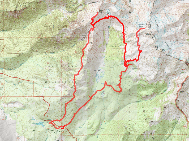
| Date | 9/13-9/14/2013 |
| Location / Trail | Goat Rocks Wilderness backpack trip |
| Weather | Sunny |
| Hiking Buddies | Carly |
| Distance / Elev | 26.5 Miles |

A bit further up, in a small sidehill meadow, things started getting interesting when we could start to see the views that would be everywhere all weekend.


And our first glimpse at a mountain (I think this was Ranier):

As we climbed higher, we could start to see some of the Jordan Creek drainage below us:

And a bit further, we could see exactly where we had to go – to go through a saddle and pop out into the Goat Creek Drainage:

Once at the top of this trail, we got a GREAT view of the Jordan Creek drainage:

At the top, there was a small meadow with Jordan creek running through it (a great source of water!) and a few nice campsites:

We watered up at the creek, took a little rest, and then headed up the rest of the way to the saddle. From there, it was pretty much downhill to Goat Lake:

It was an amazing sight. Middle of September and STILL having ice floating on it! And still some snow in places. This place must get a LOT of snow in the winter. And finally, the guys who gave this place its name (I’m guessing):

They are hard to see, however there was probably 12-15 of them on the opposite side of the lake when we came down. That was the best view we were going to get all weekend, unfortunately. After enjoying the view for a bit, we headed down the trail in search of our campsite. Having never been here, I wasn’t quite sure what the possibilities were. I had been told there was a nice site a little bit from the lake. I always like to camp near water, and trees are always nice (for a little privacy). We found a really nice spot about a mile from the lake:

It even had a pretty decent view of Mt Adams:

By the time we got to our campsite, it was time for dinner. We setup camp, cooked dinner, cleaned up and by then it was starting to get dark and we were both tired, so we just went to bed. The next morning, we got up pretty much with the sun, made breakfast, cleaned up and then were on our way for our day hikes. The plan was to go up to Hawkeye Point in the morning, come back to camp to eat lunch, and then head over to the PCT to go up and explore the area around Old Snowy. On our way to Hawkeye point, we got to enjoy this nice view from the north end of the Goat Creek drainage (near Goat Lake):

We headed around the lake and then took the cutoff trail up to Hawkeye Point. The trail was rather steep:

Once on top, we looked down upon Goat Lake:

And got a great look at Mt Ranier:

Here are two panoramic photos from up on top of Hawkeye Point:


They don’t even begin to capture the awesomeness of that view! After enjoying the view for a while, we actually started to get a bit chilly. It was a bit breezy up on top. So, after taking in the view a bit more, we headed back down and had a pretty uneventful trip back to camp. On the way back, we met a group who was on the way out, informing us that there was supposed to be rain coming in that night. The weather report I had heard said it should hold off until Sunday afternoon, but he was pretty sure it was going to rain. When we got back to camp, we talked a bit about how we really didn’t want to wake up in the rain. So, we decided to do our afternoon hike (up the PCT) and see how we felt and what things looked like when we got back to camp – we could decide then whether or not to hike out, or stay the night.
After eating a quick lunch, we headed south down the trail and soon came across this really cool, interesting waterfall:

One of my maps shows it as “slide falls”, which is pretty descriptive. It is right next to a big rockslide. We continued south until we met the Snowgrass trail and then headed east to meet the PCT:

At this point, we were essentially above the treeline and everything was heavily exposed, but the views were amazing:

We passed below Old Snowy:

And continued north (and up) to a ridge where we got a great (although different) view of Goat Lake:

We continued north on the PCT, across a snowfield until the junction with the trail up to Old Snowy. We knew we really didn’t have enough time to climb Old Snowy, so we opted to stop there to refuel a bit. We had a great view of Mt Ranier:

and the Packwood Glacier:

After we refueled, we headed back down to camp. On the way up, we had seen horses way in the distance, but didn’t figure we would see them. Well, they were apparently doing a day trip near where we turned around. On the way back down, we saw them:

We continued back down the way we came, stopping once to get more water (we went through a LOT of water!!!) and then got back to camp about 4:40. We talked about what we wanted to do, and a nice warm shower and a comfy bed sounded kind of good. We had done everything we had set out to do – all we would do in the morning would have been to pack up and hike out. We figured we had just enough time to hike out before it got dark. So, we quickly packed up and headed south down the trail. We had already logged about 13 or 14 miles, but we were determined to make it home. The trail is essentially all downhill (minus a couple of short uphill segments) to the trailhead. We were counting on that to allow us to make better time. We did catch one nice break, though. When I was looking at the map, it showed the trail going down to the floor of the drainage, then crossing Goat Creek, and then heading back uphill about 500 feet before dropping back down to the trailhead. I thought that was kind of stupid, but figured that there must be a reason. Well, we went back uphill about 100′, and then the trail was pretty much just level. The map was wrong! Either the trail got re-routed, or the map was just plain wrong. I didn’t care, it was just nice not to have to go up and then back down right at the end of the hike.
I had one really neat thing happen on the way down – at one of the rockslides, I heard the typical “meep” from the pikas that live there. I never really looked at the rockslides, thinking the pikas were hiding (as I had always seen). Well, on this rockslide, the pika was right there! And when I looked at him, he ran over to me! I wasn’t going to feed him, but he was really cute. I didn’t have enough time to get the camera out take a picture – when he realized I didn’t have anything for him, he darted off back down the rocks. MAN those guys can run fast! It was still cool, though.
We ended up getting to the truck about 7:45, just as it was getting dark – although we did use flashlights for the last bit of trail. It gets REALLY dark in the woods! We were tired, but glad to be back to the truck. Then we just had to drive the 15 miles of washboarded forest service road to get back to a real paved highway, and then make our way home. We made two stops on the way home – one for dinner (which we had skipped) and one for gas. We finally ended up at home at about 11:30pm. A VERY long day. But, it was really nice to be able to take a shower and sleep in my own bed.
I really enjoyed this trip – I always enjoy the trips with Carly, and this was no exception. I was a bit worried about the reports of how busy the place is. It was really busy, but I never felt like we weren’t in the wilderness. It wasn’t THAT busy. And, it was kind of fun to talk to some of the other hikers on the trail. We are already talking about next year – the Enchantments. That will be another epic trip – even bigger than the last two!