
| Date | 9/2/2013 |
| Location / Trail | Shellrock Lake, Cutoff Trail (between Shellrock Lake and Cache Meadow), East end of Grouse Point Trail and finally, Frazier Mountain |
| Weather | Partly Cloudy |
| Hiking Buddies | Don |
| Start / End | 10:25 AM – 3:35 PM |
| Distance / Elev | 7.3 miles |
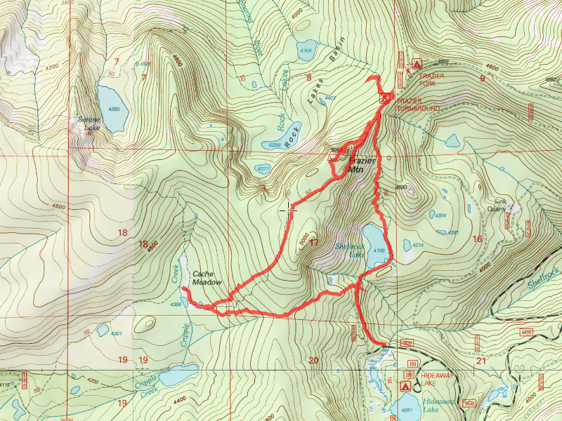
Since Don knew the cutoff trail location, and he also wanted to go up on Frazier Mountain, he came with me. We started at the Shellrock Lake trailhead parking lot about 10:30 under sunny skies. Shellrock lake starts through a clearcut, and it pretty open and hot, but thankfully, it wasn’t too warm this day. Almost immediately after entering the forest from the clearcut, there are 2 posts on the side of the trail (wonder what they used to say?). This was our clue to head uphill to find the cutoff trail. You only have to head uphill 100 yards or so and you’ll see blazes and the trail. It is in pretty good shape – amazing shape actually, for a trail that is no longer used. We made our way up this trail until we came to the first “excitement” of the day – a nest of wasps/hornets/yellow jackets that had been dug up next to the trail (just like the hike from 2 days ago where I got stung 3 or 4 times). I tried REALLY hard to be careful around it, but I ended up getting stung on my left hand anyway. STUPID BEES! Don gave me some Benadryl which helped a bit.
The trail starts getting a little sketchy towards the bottom of the hill, but following blazes helped us stay the course. Once it gets to the bottom where it starts getting wet, we kind of lost it for a bit, but quickly located some more blazes and then it was easy to follow to the point where it meets the Grouse Point trail near Cache Meadow. We headed west on the Cache Meadow trail until we got to the site of the old cabin there:

We walked a little farther east, to the point where the Cache Meadow trail intersects, and then turned around. We got a good view of Cache Meadow “proper”:

And found an interesting sign that had been eaten by a tree (not exactly sure what it said):

And another sign that looked like a woodpecker attacked it:

Once we got done looking around Cache Meadow, we turned around and started heading east up the Grouse Point trail. Up the hill….to the first rockslide of the day:

And finally to the end of the old Frazier road, which is now trail:

The road continued southwest from where the trail meets it, however we did not explore that section. We had other things to explore this day. We proceeded up the old road, which was really nice walking – to the next rockslide:

On a clear day, it would have an AWESOME view of Mt Hood, but on this day, it was hiding in the clouds. Here is what the old road looked like through the rockslide:

We continued up the road until we got to Frazier Turnaround. Another old trail that interested me was the old South Fork Roaring River (511) trail. Supposedly there was a junction off the Serene Lake trail not too far from the beginning. Don had seen it quite a few years ago, and we headed up to see if we could find it. We didn’t go too far, but couldn’t find the old junction – a quest for another day. We stopped to eat lunch at Frazier Turnaround and then headed back down the Grouse Point trail (east) to a jump off point to make our way up to the top of Frazier Mountain. Our plan was just to walk the ridge from the road up to the top of Frazier Mountain. We did, and it wasn’t long before we found an old trail!

The trail is pretty overgrown, but we guessed this must have been the route before the road was built. Once up on top, we got some great views:

And found evidence of the old phone box and phone line:


One more interesting thing – Don had seen from one of the old lookout photos (from the 30’s) a very clear “line” across a rockslide above the South Fork Roaring River – it certainly looked like a very clear trail. Since we were up at a similar vantage point, we decided to see if we could see the same “line”. The view was a little more obscured due to the trees being much larger, but we did see a very clear “line” on the rockslide:

This anomaly really needs to be investigated. That trail heading up the South Fork would be AWESOME if it could be located. This visual clue certainly looks like a trail, however it will be need to be investigated up close to determine exactly what this “line” is. Maybe it is the first hard evidence that the 511 actually exists?
Once we enjoyed the view from the top, we followed some blazes west until we hit the flat area west of the summit of Frazier Mountain at which point we lost the trail – so we just headed south to go back to the Grouse Point trail. Once on the trail, we headed back to the junction with the Shellrock Lake trail and headed down the 700 trail until we got to Shellrock Lake:

We took in the views of the lake (and the MANY campsites surrounding it) and continued back towards the beginning of our journey.
We got back to the parking lot around 3:30 – a day well used and lots of new things found and as usual, more items to explore another day.
A short stop at Fearless in Estacads for a beer made a great ending to the day.