
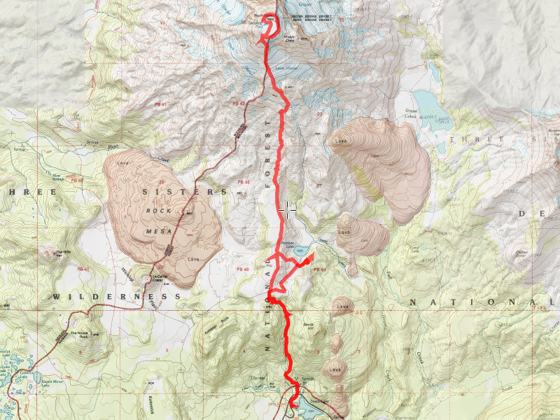
| Date | 9/6/2015 - 9/7/2015 |
| Location / Trail | South Sister Summit Trail |
| Weather | Sunny |
| Hiking Buddies | Kirk, Sarah and Daniel |
| Distance / Elev | 13.1 miles |
We ended up leaving quite a bit later than we planned – something like 2:30pm. That put us at the trailhead around 6:30-6:45. The days are getting shorter now, so we were kind of racing the sun to get to the lake before it got dark.
Our view of Broken Top on the way into Moraine Lake:

We barely made it to Moraine lake before it got dark, but then we had to find the “posts” where the designated campsites are. Fortunately, Kirk had been here before and had some idea where they were. After a bit of searching, he found one, and we setup camp in the dark, followed by cooking dinner in the dark. We then went to bed – the goal was to start off relatively early to beat the crowds. I have to say, it was kind of a strange experience wandering around in the dark woods looking for a post.
We got up (mostly) with the sun, ate breakfast and broke down our camp. We hiked over to meet the climbers trail and stashed our packs in the trees for the day. We then headed up the 5+ miles to the top of South Sister.
Here is a view of Moraine Lake with our objective (South Sister) in the background:

The trail at the start is like small road – nothing like I’m used to hiking – and South Sister is always in view to the north:

We made our way up – the trail isn’t too steep at this point, although the air continues to get thinner and the soil is pretty loose in places. After a couple of hours, and a few rest stops, we made it to this lake below the Lewis glacier:

Kirk filled up with some water, we rested a bit and then started the hardest part of the climb. You can see the route in the picture above – we go to the left on the ridge and work our way up. It seems like it continues to get steeper. And there were a lot of people on the mountain this day:

Most of the way up, we got a good view of this interesting formation – not sure what it is, but I found it very intriguing:

After numerous rest breaks, we finally made it to the crater rim where we had lunch – a view from the crater rim:

This was where all the hard work made it all worth it. The views were spectacular:
Broken Top:

The snow in the crater at the top – looking across to the true summit:

The best view from below the true summit – looking north to Middle and North Sister, 3 Finger Jack, Mt Jefferson and Mt Hood in the distance.

We mostly walked around the crater rim, although we bypassed the jagged SW part and ended up walking thru the crater. This is where the Teardrop pool would be most years – I guess the lack of snow this year dried it up.

After exploring around the top of the mountain for a while, we started our way back down, which was almost as hard as going up since the ground is so loose. You have to watch your footing going down. We made pretty good time down the hill, stopping a few times to rest and drink some water. We found our packs we had stashed in the trees and got back to the van about 5:30. We stopped in Bend for dinner and then headed home.
It was a quick trip but a really good one – interesting. Now I can say I have climbed a “glaciated peak” – I guess I can join the Mazamas!