
| Date | 3/6/2021 |
| Location / Trail | Douglas Trail - 781 |
| Weather | Partly Sunny |
| Hiking Buddies | Kirk, Ollie and Thor |
| Start / End | 9:45 AM – 3:30 PM |
| Distance / Elev | 9.1 miles 2300 ft elevation |
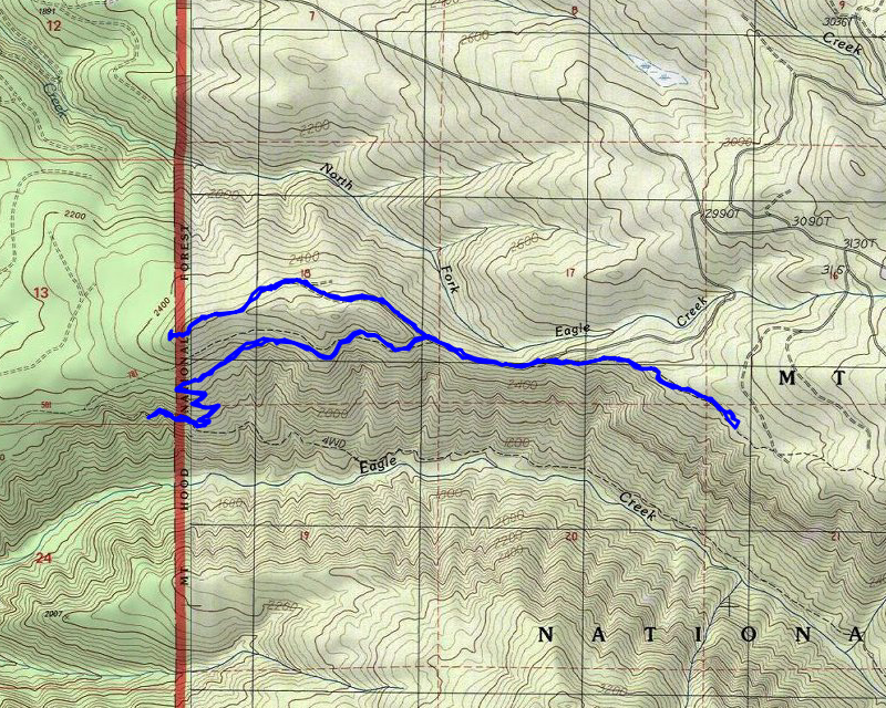
We started out at the normal time and headed up to the “other” Eagle Creek trailhead (Harvey Road Trailhead). We decided to park at the new landing since I had driven down there last week. It takes a little bit off the hike. We weren’t sure exactly how far we were going to go – it depended upon our energy and how the day progressed.
We set off down the old road from the new landing and very quickly got to the Douglas trail junction. From this point, we started our uphill climb. We started at just under 2000 feet and got up to almost 3000′, kind of going up and down in the process.
After several switchbacks and going thru old growth and cut areas, we popped out on the old 3626-255 spur road which has been closed. At this point, we decided to head west to the site of the old lookout to see what we could find. It was rather challenging, since the road to the west was all ripped up. This is what it looked like:
![]()
The section that the trail heads down (east) was left intact thankfully. We made our way west on the ripped up road, navigating the rather deep snow and the big piles on the road. At one point we thought about heading up to the ridge, wondering if it might be easier walking thru the trees than down the road, but there was a pretty significant cut bank and by the time the cut bank disappeared the road evened out and got easier to traverse (they stopped the decommissioning).
Partway up to the site of the old lookout, the sun made an appearance and I captured this cool sunray effect thru the trees:
![]()
It wasn’t too long after that and we got to the literal end of the road – somewhere in this neighborhood was where the lookout used to be (it was abandoned in 1957-64 years is a LONG time in the woods).
![]()
We looked around in the brush and groundcover for a while trying to find some remnants of the lookout, but we couldn’t find anything. It is pretty well grown over and the groundcover is pretty thick.
After looking around for a while, we decided to head down the “continuation” of the road – we were guessing that it was an old quad track, probably coming up from one of the roads down below:
![]()
We walked down the quad track to the Forest Boundary – about this point it started taking a steep turn downhill and we didn’t really feel like losing a bunch of elevation, so we decided to turn around. It we getting near lunchtime, so we went and found the best view we could (which wasn’t great) and had lunch.
After eating lunch, we headed back to the quad track/trail and then the road and headed east, back down the ripped up road. After a short section, the trail heads off the road again and we continued east. It was shortly after this that the trail started getting snow on it – we kept gaining elevation. This is what the trail looked like in the area – east of the 3626-255 spur:
![]()
The goal for the day was to get to at least the place where we came down and met the trail last year, so we can say we hiked the whole trail. We soon got to the place we joined the trail last year and then decided to turn around.
While we were coming up the trail, we noticed a spot where it looked like the trail used to continue straight ahead. The trail now took a sharp turn. On the way back, we decided to follow this “old alignment” and did indeed find it was the old alignment and went across a wet area/old spring. It almost looked like there might have been a bridge over the we area but it was hard to be certain. We followed it a bit further and saw where it rejoined the trail. We both remembered seeing this on the last trip and guessing the trail had been rerouted but we weren’t sure why. The old alignment was much straighter but maybe that wet crossing was too problematic or something. This segment was only one of several re-alignments we found (or think we found) during the day.
We soon made it back to the 255 spur road and continued west. We saw quite a few deer and possibly elk tracks in the snow on the road as well as what looked to be a small kitty (Lynx? Coyote?) We quickly made it back to where the trail heads off from the road. We let the dogs play in the last of the snow and then headed down.
As we were headed down this segment of trail, we had a bunch of different precipitation events. It sleeted for a bit, it rained, and there was rain mixed with snow. None of it was heavy or long lasting but it made for an interesting trip down.
It wasn’t too long before we were back at the junction with the Eagle creek trail. We headed up the road to the landing. The last thing we were going to look for was the quad track coming down. The maps show the Douglas trail hitting the Eagle Creek trail quite a bit farther west than it actually does – we were thinking maybe that was where the quad track was. After looking for it for a bit, our guess is that the quad track probably comes down somewhere on the road above the trailhead. Something to look for some day.
A stop at Fearless on the way home for an early dinner was a great way to end the day. Fearless was REALLY busy – I guess there is a lot of pent up demand for eating out since covid restrictions have loosened up a bit.