
| Date | 3/27/2021 |
| Location / Trail | Eagle Creek and Douglas Trails - 501, 781 |
| Weather | Sunny |
| Hiking Buddies | Kirk, Zack, Ollie and Thor |
| Start / End | 10:00 AM – 2:20 PM |
| Distance / Elev | 5.3 miles 1500 ft elevation |
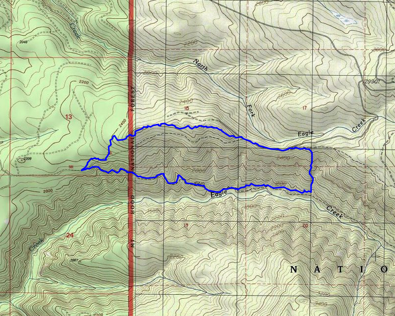
We headed out at our “normal” time, and got to the trailhead. There were already 5 or 6 cars there which is unusual, but with so many trails closed due to the fires, it is kind of expected. We headed down the road and pretty quickly got onto the “real” trail where it enters the old growth. This trail is so lush and has some gorgeous old growth on it. The constant sound of Eagle creek is pleasant as well.
We got down a couple of miles and the decided to head uphill. We spread out as we were going uphill, looking for signs of trail. We did find a few spots that kind of looked like tread, but it didn’t last very long. We looked for blazes, cut logs and insulators. The only thing we found was the one cut log:

Not too far away from this we found this old campground:

We continued up the hill and eventually joined with the Douglas trail a little east of where it hits the old 255 spur road. We hit tiny spots of snow on the way up the hill and when we got to the top, there was patchy snow. There was a couple of inches on the road – the dogs enjoyed that quite a bit.
We headed west down the road until the spot where the trail takes off again. We weighed our options and decided to go up the trail a bit and then basically follow the ridge. A little ways up the hill, we found what looked like tread – as we proceeded along it was definitely tread and it seemed to kind of come and go, but basically followed the ridge. There is a lot of salal up there which made it tougher in spots. We didn’t go too far, when Kirk found the remains – right on this tread:


We looked around a bit and then decided to have lunch. After lunch, we decided to continue following the tread we had found. It kind of continued to come and go, but we mostly followed tread along the ridge. We got to one open spot where there were these HUGE, ancient vine maples – they looked like huge spiders or something:

As we continued trying to follow the tread, we did end up finding one cut log:

It was shortly after this that we lost the trail completely, but we were very close to the old road, so we walked over there and then continued west. We walked past the end of the road down what we figued was an old quad track. When we were here a few weeks ago, we followed it down to the point where it took a steep turn down the hill. Today we continued down the hill – we were assuming this would eventually bring us out onto an old road that we could walk back to the van. That turned out to be a completely correct assumption. The track continued down the hill, soon getting into a cut area (15-20 year old cut probably) and then down onto an old road. The road has been bermed for a few years so no one has driven up that far, but we did see recent evidence of cutting back some brush.
It wasn’t long before we were back at the van. By this time there were probably 10 vehicles at the trailhead. We loaded up and headed out. It was a great day of exploring on an absolutely beautiful spring day.